
Station XK S19 - South 19
Network: XK99 - CDROM (Colorado)
Nearby stations (2 deg radius)

| Station | Name | (Lat, Lon) | Start / End | Elevation |
| S19 | South 19 | (35.60, -105.18) | 1999-04-19 / 2000-12-31 | 1977 m |
| Crust2 Type: | Q2,orogen/39km no ice, Appalachians, North Andes, 0.5 km seds. |
| Thickness Estimate: | 48 km |
| Thickness StdDev: | 2.2 km |
| Vp/Vs Estimate: | 1.75 |
| Vp/Vs StdDev: | 0.08 |
| Vs Estimate: | 3.668 km/s |
| Poisson's Ratio: | 0.26 |
| Peak Value: | 0.01 |
| Assumed Vp: | 6.419 km/s |
| Ps Weight: | 0.33333334 |
| PpPs Weight: | 0.33333334 |
| PsPs Weight: | 0.33333328 |
| Residual Complexity: | 0.647 |
| Nearby stations H: | +- |
| (2.0 deg) Vp/Vs: | +- |
8 with match > 90% ( 38.095238 %) and 21 with match > 80% ( 100.0 %) out of 21.
Download stack as xyz text file.
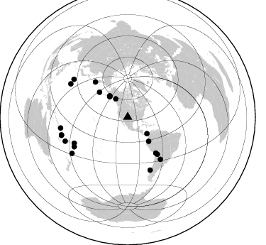
Azimuth Distribution of Events:
Prior Results for this Station
| Study | Thickness | Vp/Vs | Vp | Vs | Poissons Ratio | Extra |
| EARS | 48 km | 1.75 | 6.419 km/s | 3.668 km/s | 0.26 | |
| Crust2.0 | 39 km | 1.75 | 6.419 km/s | 3.659 km/s | 0.26 | Q2,orogen/39km no ice, Appalachians, North Andes, 0.5 km seds. |
| Global Maxima | 48 km | 1.75 | 6.419 km/s | 3.668 km/s | 0.26 | amp=0.011803622 |
| Local Maxima 1 | 42 km | 1.93 | 6.419 km/s | 3.322 km/s | 0.32 | amp=0.0086617 |
| Local Maxima 2 | 45 km | 1.82 | 6.419 km/s | 3.527 km/s | 0.28 | amp=0.004941771 |
| Local Maxima 3 | 28 km | 1.60 | 6.419 km/s | 4.012 km/s | 0.18 | amp=0.0040605385 |
| Local Maxima 4 | 40 km | 2.09 | 6.419 km/s | 3.075 km/s | 0.35 | amp=0.0035070844 |
| Predicted Arrivals for vertical incidence (zero ray parameter) | |
| Ps | 5.55 SECOND |
| PpPs | 20.35 SECOND |
| PsPs/PpSs | 25.90 SECOND |
Events Processed for this Station
Download zip of receiver functions as SAC
Plot maxima for each earthquake.
Events Used in the Stack
(21 events)| Radial Match | Distance | Baz | FERegion | Time | Lat/Lon | Depth | Magnitude |
| 98.68264 | 83.6 deg | 244.106 deg | Tonga Islands | 2000/01/08 16:47:20 GMT | (-16.9, -174.2) | 183 km | 6.5 MB, 6.6 MS, 7.2 MW, 7.0 ME |
| 98.09645 | 93.0 deg | 300.112 deg | Volcano Islands, Japan Region | 2000/03/28 11:00:22 GMT | (22.3, 143.7) | 126 km | 6.8 MB, 7.6 MS, 7.6 MW, 7.6 MW |
| 96.287155 | 96.7 deg | 254.708 deg | Vanuatu Islands | 1999/11/26 13:21:15 GMT | (-16.4, 168.2) | 33 km | 6.4 MB, 7.3 MS, 7.5 MW, 7.3 MW |
| 95.581566 | 39.2 deg | 319.528 deg | Kodiak Island Region, Alaska | 1999/12/06 23:12:33 GMT | (57.4, -154.5) | 66 km | 6.8 MB, 7.0 MW, 7.0 ML |
| 95.08774 | 93.4 deg | 237.094 deg | Kermadec Islands Region | 1999/07/19 02:17:03 GMT | (-28.6, -177.6) | 39 km | 6.3 MB, 6.2 MS, 6.4 MW, 6.3 ME |
| 94.43687 | 38.2 deg | 318.256 deg | Kodiak Island Region, Alaska | 1999/05/07 14:13:52 GMT | (56.4, -152.9) | 20 km | 5.7 MB, 6.1 MS, 6.4 MW, 5.7 ME |
| 91.82439 | 75.0 deg | 142.184 deg | Santiago Del Estero Prov., Arg. | 2000/04/23 09:27:23 GMT | (-28.3, -63.0) | 608 km | 6.6 MB, 7.0 MW, 7.0 MW |
| 91.11543 | 35.6 deg | 130.552 deg | Panama | 2000/02/26 18:24:39 GMT | (9.4, -78.5) | 65 km | 5.8 MB, 5.4 MS, 6.2 MW, 6.1 MW |
| 89.89328 | 53.0 deg | 311.472 deg | Andreanof Islands, Aleutian Is. | 2000/04/21 04:35:17 GMT | (51.4, -178.1) | 33 km | 6.0 MB, 5.7 MS, 6.2 ML, 6.0 MW |
| 89.71748 | 44.9 deg | 138.893 deg | Ecuador | 1999/08/28 12:40:06 GMT | (-1.3, -77.5) | 196 km | 5.9 MB, 6.3 MW, 6.2 MW |
| 89.63308 | 80.7 deg | 156.969 deg | Off Coast Of Southern Chile | 1999/08/22 09:35:39 GMT | (-40.5, -74.8) | 33 km | 6.2 MB, 5.8 MS, 6.4 MW, 6.2 MW |
| 89.49633 | 94.1 deg | 249.069 deg | Vanuatu Islands Region | 2000/02/25 01:43:58 GMT | (-19.5, 173.8) | 33 km | 6.1 MB, 7.1 MS, 7.1 MW, 7.0 MW |
| 87.90628 | 66.7 deg | 141.3 deg | Southern Bolivia | 1999/09/15 03:01:24 GMT | (-20.9, -67.3) | 218 km | 6.0 MB, 6.4 MW, 6.4 MW |
| 86.73842 | 86.1 deg | 241.163 deg | Tonga Islands | 2000/01/02 15:16:32 GMT | (-20.8, -174.2) | 33 km | 5.5 MB, 5.8 MS, 5.8 MW, 5.8 MW |
| 85.23632 | 39.2 deg | 319.445 deg | Kodiak Island Region, Alaska | 1999/12/07 00:19:49 GMT | (57.4, -154.5) | 41 km | 6.5 MB, 6.1 MS, 6.4 MW, 6.3 ML |
| 82.8369 | 95.8 deg | 260.868 deg | Santa Cruz Islands | 1999/12/29 13:29:19 GMT | (-10.9, 165.4) | 33 km | 5.6 MB, 6.8 MS, 6.8 MW, 6.3 MW |
| 82.39077 | 92.6 deg | 305.055 deg | Bonin Islands, Japan Region | 1999/07/03 05:30:10 GMT | (26.3, 140.5) | 431 km | 6.0 MB, 6.1 MW, 6.0 MW |
| 82.26465 | 67.3 deg | 317.442 deg | Near East Coast Of Kamchatka | 1999/09/18 21:28:33 GMT | (51.2, 157.6) | 60 km | 5.9 MB, 5.6 MS, 6.2 MW, 6.0 MW |
| 81.692795 | 64.1 deg | 141.754 deg | Northern Chile | 1999/11/30 04:01:53 GMT | (-18.9, -69.2) | 128 km | 6.2 MB, 6.6 MW, 6.5 MW |
| 80.895775 | 30.7 deg | 326.857 deg | Southeastern Alaska | 2000/01/06 10:42:25 GMT | (58.0, -136.9) | 1.0 km | 5.5 MB, 5.9 MS, 6.1 MW, 6.1 ML |
| 80.78713 | 96.7 deg | 255.056 deg | Vanuatu Islands | 1999/08/22 12:40:45 GMT | (-16.1, 168.0) | 33 km | 6.3 MB, 6.2 MS, 6.5 MW, 6.5 MW |
Losers
(0 events)| Radial Match | Distance | Baz | FERegion | Time | Lat/Lon | Depth | Magnitude | Reason |
