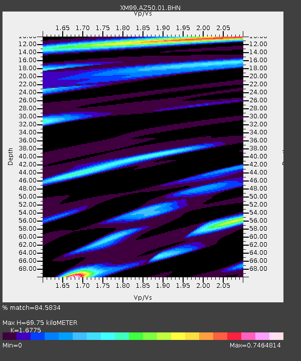
AZ50 Arizona50 - Earthquake Result Viewer
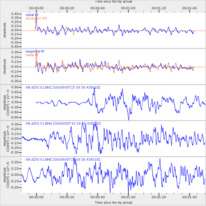
Earthquake location: Southeast Of Ryukyu Islands
Earthquake latitude/longitude: 29.4/131.4
Earthquake time(UTC): 2000/06/06 (158) 14:57:02 GMT
Earthquake Depth: 33 km
Earthquake Magnitude: 5.8 MB, 6.0 MS, 6.4 MW, 6.4 MW
Earthquake Catalog/Contributor: WHDF/NEIC
Network: XM Rio Grande Seismic Transect
Station: AZ50 Arizona50
Lat/Lon: 36.98 N/109.86 W
Elevation: 1469 m
Distance: 92.5 deg
Az: 44.666 deg
Baz: 310.019 deg
Ray Param: 0.041443102
Estimated Moho Depth: 69.75 km
Estimated Crust Vp/Vs: 1.68
Assumed Crust Vp: 6.476 km/s
Estimated Crust Vs: 3.86 km/s
Estimated Crust Poisson's Ratio: 0.22
Radial Match: 84.5834 %
Radial Bump: 400
Transverse Match: 62.48374 %
Transverse Bump: 400
SOD ConfigId: 3744
Insert Time: 2010-02-26 17:35:40.846 +0000
GWidth: 2.5
Max Bumps: 400
Tol: 0.001

Signal To Noise

ChannelStoNSTALTA
XM:AZ50:01:BHN:20000606T15:09:38.438018Z0.538622442.713714E-85.0382493E-8
XM:AZ50:01:BHE:20000606T15:09:38.438018Z1.37026246.8957334E-85.0324182E-8
XM:AZ50:01:BHZ:20000606T15:09:38.438018Z1.11660728.502597E-87.614672E-8
Arrivals
Ps7.5 SECOND
PpPs28 SECOND
PsPs/PpSs36 SECOND