
Station XM AZ50 - Arizona50
Network: XM99 - Rio Grande Seismic Transect
Nearby stations (2 deg radius)
| Station | Name | (Lat, Lon) | Start / End | Elevation |
| AZ50 | Arizona50 | (36.98, -109.86) | 1999-07-29 / 2001-12-31 | 1469 m |
| Crust2 Type: | Q6,orogen/41.5km no ice, cordilleras, 1.5 km seds. |
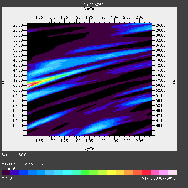
| Thickness Estimate: | 50 km |
| Thickness StdDev: | 7.5 km |
| Vp/Vs Estimate: | 1.60 |
| Vp/Vs StdDev: | 0.13 |
| Vs Estimate: | 4.047 km/s |
| Poisson's Ratio: | 0.18 |
| Peak Value: | 0.00 |
| Assumed Vp: | 6.476 km/s |
| Ps Weight: | 0.33333334 |
| PpPs Weight: | 0.33333334 |
| PsPs Weight: | 0.33333328 |
| Residual Complexity: | 0.778 |
| Nearby stations H: | +- |
| (2.0 deg) Vp/Vs: | +- |
9 with match > 90% ( 39.130436 %) and 23 with match > 80% ( 100.0 %) out of 23.
Download stack as xyz text file.
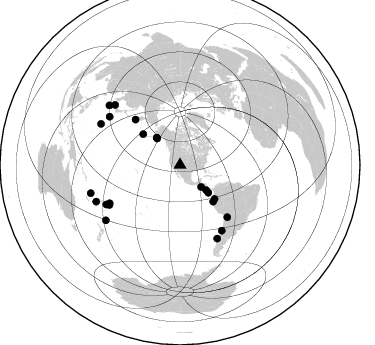
Azimuth Distribution of Events:
Prior Results for this Station
| Study | Thickness | Vp/Vs | Vp | Vs | Poissons Ratio | Extra |
| EARS | 50 km | 1.60 | 6.476 km/s | 4.047 km/s | 0.18 | |
| Crust2.0 | 42 km | 1.76 | 6.476 km/s | 3.675 km/s | 0.26 | Q6,orogen/41.5km no ice, cordilleras, 1.5 km seds. |
| Wilson | 45 km | 1.75 | 6.41 km/s | 3.663 km/s | 0.26 | |
| Global Maxima | 50 km | 1.60 | 6.476 km/s | 4.047 km/s | 0.18 | amp=0.0038775813 |
| Local Maxima 1 | 47 km | 1.70 | 6.476 km/s | 3.804 km/s | 0.24 | amp=0.0017836879 |
| Local Maxima 2 | 67 km | 1.88 | 6.476 km/s | 3.449 km/s | 0.30 | amp=0.0014887664 |
| Local Maxima 3 | 64 km | 1.67 | 6.476 km/s | 3.872 km/s | 0.22 | amp=0.0013676386 |
| Local Maxima 4 | 43 km | 1.67 | 6.476 km/s | 3.878 km/s | 0.22 | amp=0.0012229206 |
| Predicted Arrivals for vertical incidence (zero ray parameter) | |
| Ps | 4.66 SECOND |
| PpPs | 20.17 SECOND |
| PsPs/PpSs | 24.83 SECOND |
Events Processed for this Station
Download zip of receiver functions as SAC
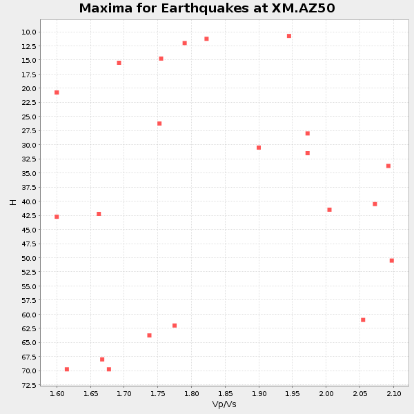
Plot maxima for each earthquake.
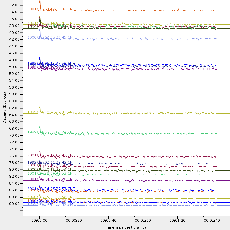
Events Used in the Stack
(23 events)| Radial Match | Distance | Baz | FERegion | Time | Lat/Lon | Depth | Magnitude |
| 98.0949 | 89.0 deg | 297.342 deg | Volcano Islands, Japan Region | 2000/03/28 11:00:22 GMT | (22.3, 143.7) | 126 km | 6.8 MB, 7.6 MS, 7.6 MW, 7.6 MW |
| 97.5532 | 30.5 deg | 135.96 deg | El Salvador | 2001/01/13 17:33:32 GMT | (13.0, -88.7) | 60 km | 6.4 MB, 7.8 MS, 7.7 MW, 7.5 ME |
| 96.068214 | 36.3 deg | 133.6 deg | Costa Rica | 1999/08/20 10:02:21 GMT | (9.0, -84.2) | 20 km | 6.1 MB, 6.9 MS, 7.0 MW, 6.1 ML |
| 94.324234 | 93.4 deg | 252.506 deg | Vanuatu Islands | 1999/08/22 12:40:45 GMT | (-16.1, 168.0) | 33 km | 6.3 MB, 6.2 MS, 6.5 MW, 6.5 MW |
| 91.943245 | 35.7 deg | 319.351 deg | Kodiak Island Region, Alaska | 1999/12/06 23:12:33 GMT | (57.4, -154.5) | 66 km | 6.8 MB, 7.0 MW, 7.0 ML |
| 91.51014 | 91.2 deg | 246.435 deg | Vanuatu Islands Region | 2000/02/25 01:43:58 GMT | (-19.5, 173.8) | 33 km | 6.1 MB, 7.1 MS, 7.1 MW, 7.0 MW |
| 91.07306 | 70.2 deg | 137.758 deg | Southern Bolivia | 1999/09/15 03:01:24 GMT | (-20.9, -67.3) | 218 km | 6.0 MB, 6.4 MW, 6.4 MW |
| 90.48953 | 83.6 deg | 241.853 deg | Fiji Islands Region | 2001/04/28 04:49:53 GMT | (-18.1, -176.9) | 352 km | 6.2 MB, 6.8 MW, 6.8 MW |
| 90.1626 | 92.4 deg | 233.308 deg | Kermadec Islands, New Zealand | 1999/08/01 08:39:04 GMT | (-30.4, -177.8) | 10 km | 5.7 MB, 6.4 MS, 6.6 MW, 6.0 ME |
| 89.92155 | 88.5 deg | 312.634 deg | Western Honshu, Japan | 2001/03/24 06:27:53 GMT | (34.1, 132.5) | 50 km | 6.4 MB, 6.5 MS, 6.8 MW, 6.4 ME |
| 89.70849 | 48.5 deg | 134.43 deg | Ecuador | 1999/08/28 12:40:06 GMT | (-1.3, -77.5) | 196 km | 5.9 MB, 6.3 MW, 6.2 MW |
| 88.79455 | 63.7 deg | 315.499 deg | Near East Coast Of Kamchatka | 1999/09/18 21:28:33 GMT | (51.2, 157.6) | 60 km | 5.9 MB, 5.6 MS, 6.2 MW, 6.0 MW |
| 88.539085 | 34.9 deg | 319.12 deg | Kodiak Island Region, Alaska | 2001/01/10 16:02:44 GMT | (57.1, -153.2) | 33 km | 6.2 MB, 6.8 MS, 7.1 MW, 6.8 ML |
| 88.22447 | 48.1 deg | 309.708 deg | Andreanof Islands, Aleutian Is. | 1999/08/01 12:47:50 GMT | (51.5, -176.3) | 33 km | 5.5 MB, 5.5 MS, 5.8 MW, 5.8 MW |
| 88.19338 | 39.6 deg | 134.5 deg | South Of Panama | 2000/12/12 05:26:45 GMT | (6.0, -82.7) | 10 km | 5.8 MB, 5.7 MS, 6.3 ME, 6.1 MW |
| 87.01252 | 81.0 deg | 240.526 deg | Tonga Islands | 2000/01/26 13:26:50 GMT | (-17.3, -174.0) | 33 km | 5.9 MB, 6.0 MS, 6.4 MW, 6.3 MW |
| 84.60235 | 82.3 deg | 153.048 deg | Off Coast Of Central Chile | 2000/12/20 11:23:54 GMT | (-39.0, -74.7) | 11 km | 6.1 MB, 6.2 MS, 6.4 MW, 6.0 ME |
| 84.5834 | 92.5 deg | 310.019 deg | Southeast Of Ryukyu Islands | 2000/06/06 14:57:02 GMT | (29.4, 131.4) | 33 km | 5.8 MB, 6.0 MS, 6.4 MW, 6.4 MW |
| 83.18409 | 77.7 deg | 147.458 deg | Near Coast Of Central Chile | 2001/03/15 13:02:42 GMT | (-32.3, -71.5) | 37 km | 6.1 MB, 5.6 MS, 6.0 MW, 5.4 MD |
| 81.84508 | 35.7 deg | 319.26 deg | Kodiak Island Region, Alaska | 1999/12/07 00:19:49 GMT | (57.4, -154.5) | 41 km | 6.5 MB, 6.1 MS, 6.4 MW, 6.3 ML |
| 81.71587 | 49.3 deg | 137.795 deg | Near Coast Of Ecuador | 1999/08/03 15:58:57 GMT | (-3.5, -79.2) | 88 km | 5.7 MB, 5.0 MS, 5.9 MW, 5.9 MW |
| 81.07411 | 85.4 deg | 304.394 deg | Southeast Of Honshu, Japan | 2001/04/14 23:27:26 GMT | (30.1, 141.8) | 10 km | 6.0 MB, 5.8 MS, 6.0 MW, 6.0 ME |
| 80.86996 | 80.0 deg | 241.516 deg | Tonga Islands | 1999/12/07 21:29:49 GMT | (-15.9, -174.0) | 138 km | 6.2 MB, 6.4 MW, 6.4 MW |
Losers
(0 events)| Radial Match | Distance | Baz | FERegion | Time | Lat/Lon | Depth | Magnitude | Reason |
