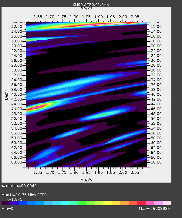
AZ50 Arizona50 - Earthquake Result Viewer
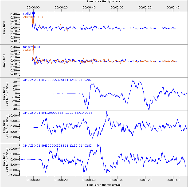
Earthquake location: Volcano Islands, Japan Region
Earthquake latitude/longitude: 22.3/143.7
Earthquake time(UTC): 2000/03/28 (088) 11:00:22 GMT
Earthquake Depth: 126 km
Earthquake Magnitude: 6.8 MB, 7.6 MS, 7.6 MW, 7.6 MW
Earthquake Catalog/Contributor: WHDF/NEIC
Network: XM Rio Grande Seismic Transect
Station: AZ50 Arizona50
Lat/Lon: 36.98 N/109.86 W
Elevation: 1469 m
Distance: 89.0 deg
Az: 50.202 deg
Baz: 297.342 deg
Ray Param: 0.041881695
Estimated Moho Depth: 10.75 km
Estimated Crust Vp/Vs: 1.95
Assumed Crust Vp: 6.476 km/s
Estimated Crust Vs: 3.33 km/s
Estimated Crust Poisson's Ratio: 0.32
Radial Match: 98.0949 %
Radial Bump: 400
Transverse Match: 90.020584 %
Transverse Bump: 400
SOD ConfigId: 27569
Insert Time: 2010-02-26 17:35:43.343 +0000
GWidth: 2.5
Max Bumps: 400
Tol: 0.001

Signal To Noise

ChannelStoNSTALTA
XM:AZ50:01:BHN:20000328T11:12:32.014028Z2.53210783.9137473E-71.5456479E-7
XM:AZ50:01:BHE:20000328T11:12:32.014028Z1.96507873.6122694E-71.8382315E-7
XM:AZ50:01:BHZ:20000328T11:12:32.014028Z1.09923052.687793E-72.4451586E-7
Arrivals
Ps1.6 SECOND
PpPs4.8 SECOND
PsPs/PpSs6.4 SECOND