You are here: Home > Network List > XK99 - CDROM (Colorado) Stations List
> Station S21 South 21 > Earthquake Result Viewer
S21 South 21 - Earthquake Result Viewer
| Earthquake location: |
Turkey |
| Earthquake latitude/longitude: |
40.7/29.9 |
| Earthquake time(UTC): |
1999/08/17 (229) 00:01:39 GMT |
| Earthquake Depth: |
17 km |
| Earthquake Magnitude: |
6.3 MB, 7.8 MS, 7.7 ME, 7.6 MW |
| Earthquake Catalog/Contributor: |
WHDF/NEIC |
|
| Network: |
XK CDROM (Colorado) |
| Station: |
S21 South 21 |
| Lat/Lon: |
35.42 N/105.20 W |
| Elevation: |
1991 m |
|
| Distance: |
93.7 deg |
| Az: |
324.685 deg |
| Baz: |
32.53 deg |
| Ray Param: |
0.04121125 |
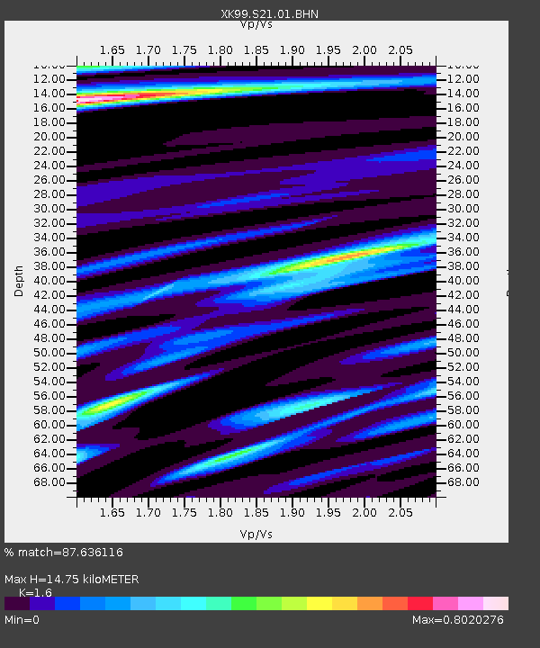
| Estimated Moho Depth: |
14.75 km |
| Estimated Crust Vp/Vs: |
1.60 |
| Assumed Crust Vp: |
6.419 km/s |
| Estimated Crust Vs: |
4.012 km/s |
| Estimated Crust Poisson's Ratio: |
0.18 |
|
| Radial Match: |
87.636116 % |
| Radial Bump: |
400 |
| Transverse Match: |
74.50063 % |
| Transverse Bump: |
400 |
| SOD ConfigId: |
287362 |
| Insert Time: |
2010-03-09 22:52:22.285 +0000 |
| GWidth: |
2.5 |
| Max Bumps: |
400 |
| Tol: |
0.001 |
|

Signal To Noise
| Channel | StoN | STA | LTA |
| XK:S21:01:BHN:19990817T00:14:22.952021Z | 2.5938613 | 4.5767456E-7 | 1.7644527E-7 |
| XK:S21:01:BHE:19990817T00:14:22.952021Z | 1.3488569 | 1.06519515E-7 | 7.897021E-8 |
| XK:S21:01:BHZ:19990817T00:14:22.952021Z | 0.6883138 | 7.832708E-8 | 1.1379561E-7 |
| Arrivals |
| Ps | 1.4 SECOND |
| PpPs | 5.8 SECOND |
| PsPs/PpSs | 7.3 SECOND |


