
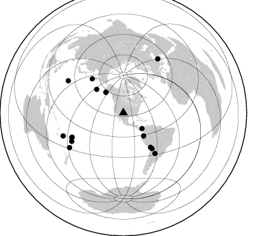
Station XK S21 - South 21
Network: XK99 - CDROM (Colorado)
Nearby stations (2 deg radius)

| Station | Name | (Lat, Lon) | Start / End | Elevation |
| S21 | South 21 | (35.42, -105.20) | 1999-04-18 / 2000-12-31 | 1991 m |
| Crust2 Type: | Q2,orogen/39km no ice, Appalachians, North Andes, 0.5 km seds. |
| Thickness Estimate: | 44 km |
| Thickness StdDev: | 1.6 km |
| Vp/Vs Estimate: | 1.79 |
| Vp/Vs StdDev: | 0.03 |
| Vs Estimate: | 3.586 km/s |
| Poisson's Ratio: | 0.27 |
| Peak Value: | 0.03 |
| Assumed Vp: | 6.419 km/s |
| Ps Weight: | 0.33333334 |
| PpPs Weight: | 0.33333334 |
| PsPs Weight: | 0.33333328 |
| Residual Complexity: | 0.413 |
| Nearby stations H: | +- |
| (2.0 deg) Vp/Vs: | +- |
4 with match > 90% ( 25.0 %) and 16 with match > 80% ( 100.0 %) out of 16.
Download stack as xyz text file.
Azimuth Distribution of Events:
Prior Results for this Station
| Study | Thickness | Vp/Vs | Vp | Vs | Poissons Ratio | Extra |
| EARS | 44 km | 1.79 | 6.419 km/s | 3.586 km/s | 0.27 | |
| Crust2.0 | 39 km | 1.75 | 6.419 km/s | 3.659 km/s | 0.26 | Q2,orogen/39km no ice, Appalachians, North Andes, 0.5 km seds. |
| Global Maxima | 44 km | 1.79 | 6.419 km/s | 3.586 km/s | 0.27 | amp=0.032776557 |
| Local Maxima 1 | 41 km | 1.92 | 6.419 km/s | 3.343 km/s | 0.31 | amp=0.011064143 |
| Local Maxima 2 | 30 km | 1.63 | 6.419 km/s | 3.944 km/s | 0.20 | amp=0.009791659 |
| Local Maxima 3 | 47 km | 1.72 | 6.419 km/s | 3.732 km/s | 0.24 | amp=0.007872317 |
| Local Maxima 4 | 25 km | 1.70 | 6.419 km/s | 3.787 km/s | 0.23 | amp=0.0066574593 |
| Predicted Arrivals for vertical incidence (zero ray parameter) | |
| Ps | 5.48 SECOND |
| PpPs | 19.34 SECOND |
| PsPs/PpSs | 24.82 SECOND |
Events Processed for this Station
Download zip of receiver functions as SAC
Plot maxima for each earthquake.
Events Used in the Stack
(16 events)| Radial Match | Distance | Baz | FERegion | Time | Lat/Lon | Depth | Magnitude |
| 98.03267 | 93.1 deg | 300.095 deg | Volcano Islands, Japan Region | 2000/03/28 11:00:22 GMT | (22.3, 143.7) | 126 km | 6.8 MB, 7.6 MS, 7.6 MW, 7.6 MW |
| 97.301704 | 83.5 deg | 244.114 deg | Tonga Islands | 2000/01/08 16:47:20 GMT | (-16.9, -174.2) | 183 km | 6.5 MB, 6.6 MS, 7.2 MW, 7.0 ME |
| 94.01447 | 39.3 deg | 319.668 deg | Kodiak Island Region, Alaska | 1999/12/06 23:12:33 GMT | (57.4, -154.5) | 66 km | 6.8 MB, 7.0 MW, 7.0 ML |
| 90.0234 | 35.5 deg | 130.348 deg | Panama | 2000/02/26 18:24:39 GMT | (9.4, -78.5) | 65 km | 5.8 MB, 5.4 MS, 6.2 MW, 6.1 MW |
| 87.636116 | 93.7 deg | 32.53 deg | Turkey | 1999/08/17 00:01:39 GMT | (40.7, 29.9) | 17 km | 6.3 MB, 7.8 MS, 7.7 ME, 7.6 MW |
| 87.61197 | 39.3 deg | 319.584 deg | Kodiak Island Region, Alaska | 1999/12/07 00:19:49 GMT | (57.4, -154.5) | 41 km | 6.5 MB, 6.1 MS, 6.4 MW, 6.3 ML |
| 87.38725 | 66.6 deg | 141.24 deg | Southern Bolivia | 1999/09/15 03:01:24 GMT | (-20.9, -67.3) | 218 km | 6.0 MB, 6.4 MW, 6.4 MW |
| 86.41248 | 63.9 deg | 141.688 deg | Northern Chile | 1999/11/30 04:01:53 GMT | (-18.9, -69.2) | 128 km | 6.2 MB, 6.6 MW, 6.5 MW |
| 85.96108 | 52.0 deg | 311.383 deg | Andreanof Islands, Aleutian Is. | 1999/08/01 12:47:50 GMT | (51.5, -176.3) | 33 km | 5.5 MB, 5.5 MS, 5.8 MW, 5.8 MW |
| 83.68738 | 74.9 deg | 142.143 deg | Santiago Del Estero Prov., Arg. | 2000/04/23 09:27:23 GMT | (-28.3, -63.0) | 608 km | 6.6 MB, 7.0 MW, 7.0 MW |
| 83.566696 | 94.1 deg | 249.049 deg | Vanuatu Islands Region | 2000/02/25 01:43:58 GMT | (-19.5, 173.8) | 33 km | 6.1 MB, 7.1 MS, 7.1 MW, 7.0 MW |
| 83.1373 | 93.3 deg | 237.077 deg | Kermadec Islands Region | 1999/07/19 02:17:03 GMT | (-28.6, -177.6) | 39 km | 6.3 MB, 6.2 MS, 6.4 MW, 6.3 ME |
| 83.057274 | 86.0 deg | 241.164 deg | Tonga Islands | 2000/01/02 15:16:32 GMT | (-20.8, -174.2) | 33 km | 5.5 MB, 5.8 MS, 5.8 MW, 5.8 MW |
| 82.1178 | 82.7 deg | 244.73 deg | Tonga Islands | 1999/12/07 21:29:49 GMT | (-15.9, -174.0) | 138 km | 6.2 MB, 6.4 MW, 6.4 MW |
| 81.134254 | 44.7 deg | 138.76 deg | Ecuador | 1999/08/28 12:40:06 GMT | (-1.3, -77.5) | 196 km | 5.9 MB, 6.3 MW, 6.2 MW |
| 80.83371 | 67.4 deg | 317.485 deg | Near East Coast Of Kamchatka | 1999/09/18 21:28:33 GMT | (51.2, 157.6) | 60 km | 5.9 MB, 5.6 MS, 6.2 MW, 6.0 MW |
Losers
(0 events)| Radial Match | Distance | Baz | FERegion | Time | Lat/Lon | Depth | Magnitude | Reason |
