You are here: Home > Network List > XK99 - CDROM (Colorado) Stations List
> Station S22 South 22 > Earthquake Result Viewer
S22 South 22 - Earthquake Result Viewer
| Earthquake location: |
Santiago Del Estero Prov., Arg. |
| Earthquake latitude/longitude: |
-28.4/-62.9 |
| Earthquake time(UTC): |
2000/04/23 (114) 17:01:17 GMT |
| Earthquake Depth: |
610 km |
| Earthquake Magnitude: |
5.8 MB, 6.2 MW, 6.1 MW |
| Earthquake Catalog/Contributor: |
WHDF/NEIC |
|
| Network: |
XK CDROM (Colorado) |
| Station: |
S22 South 22 |
| Lat/Lon: |
35.32 N/105.15 W |
| Elevation: |
1679 m |
|
| Distance: |
74.8 deg |
| Az: |
325.302 deg |
| Baz: |
142.17 deg |
| Ray Param: |
0.050056722 |
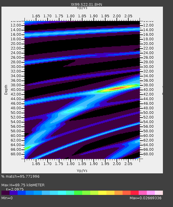
| Estimated Moho Depth: |
69.75 km |
| Estimated Crust Vp/Vs: |
2.10 |
| Assumed Crust Vp: |
6.419 km/s |
| Estimated Crust Vs: |
3.06 km/s |
| Estimated Crust Poisson's Ratio: |
0.35 |
|
| Radial Match: |
95.771996 % |
| Radial Bump: |
132 |
| Transverse Match: |
97.127144 % |
| Transverse Bump: |
128 |
| SOD ConfigId: |
287362 |
| Insert Time: |
2010-03-09 22:53:11.799 +0000 |
| GWidth: |
2.5 |
| Max Bumps: |
400 |
| Tol: |
0.001 |
|

Signal To Noise
| Channel | StoN | STA | LTA |
| XK:S22:01:BHN:20000423T17:11:25.915007Z | 0.20755988 | 4.2905756E-7 | 2.0671507E-6 |
| XK:S22:01:BHE:20000423T17:11:25.915007Z | 0.5257446 | 7.395212E-7 | 1.4066169E-6 |
| XK:S22:01:BHZ:20000423T17:11:25.915007Z | 7.237757 | 1.0139578E-6 | 1.4009282E-7 |
| Arrivals |
| Ps | 12 SECOND |
| PpPs | 33 SECOND |
| PsPs/PpSs | 45 SECOND |


