
Station XK S22 - South 22
Network: XK99 - CDROM (Colorado)
Nearby stations (2 deg radius)
| Station | Name | (Lat, Lon) | Start / End | Elevation |
| S22 | South 22 | (35.32, -105.15) | 1999-04-17 / 2000-12-31 | 1679 m |
| Crust2 Type: | Q2,orogen/39km no ice, Appalachians, North Andes, 0.5 km seds. |
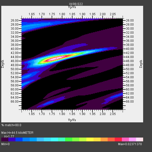
| Thickness Estimate: | 44 km |
| Thickness StdDev: | 0.3 km |
| Vp/Vs Estimate: | 1.77 |
| Vp/Vs StdDev: | 0.01 |
| Vs Estimate: | 3.627 km/s |
| Poisson's Ratio: | 0.27 |
| Peak Value: | 0.02 |
| Assumed Vp: | 6.419 km/s |
| Ps Weight: | 0.33333334 |
| PpPs Weight: | 0.33333334 |
| PsPs Weight: | 0.33333328 |
| Residual Complexity: | 0.366 |
| Nearby stations H: | +- |
| (2.0 deg) Vp/Vs: | +- |
8 with match > 90% ( 38.095238 %) and 21 with match > 80% ( 100.0 %) out of 21.
Download stack as xyz text file.
Azimuth Distribution of Events:

Prior Results for this Station
| Study | Thickness | Vp/Vs | Vp | Vs | Poissons Ratio | Extra |
| EARS | 44 km | 1.77 | 6.419 km/s | 3.627 km/s | 0.27 | |
| Crust2.0 | 39 km | 1.75 | 6.419 km/s | 3.659 km/s | 0.26 | Q2,orogen/39km no ice, Appalachians, North Andes, 0.5 km seds. |
| Global Maxima | 44 km | 1.77 | 6.419 km/s | 3.627 km/s | 0.27 | amp=0.02371378 |
| Local Maxima 1 | 46 km | 1.72 | 6.419 km/s | 3.738 km/s | 0.24 | amp=0.0072716884 |
| Local Maxima 2 | 29 km | 1.62 | 6.419 km/s | 3.95 km/s | 0.20 | amp=0.005554198 |
| Local Maxima 3 | 42 km | 1.90 | 6.419 km/s | 3.374 km/s | 0.31 | amp=0.004364198 |
| Local Maxima 4 | 58 km | 1.60 | 6.419 km/s | 4.012 km/s | 0.18 | amp=0.003955017 |
| Predicted Arrivals for vertical incidence (zero ray parameter) | |
| Ps | 5.34 SECOND |
| PpPs | 19.20 SECOND |
| PsPs/PpSs | 24.54 SECOND |
Events Processed for this Station
Download zip of receiver functions as SAC
Plot maxima for each earthquake.
Events Used in the Stack
(21 events)| Radial Match | Distance | Baz | FERegion | Time | Lat/Lon | Depth | Magnitude |
| 99.99855 | 93.1 deg | 242.333 deg | South Of Fiji Islands | 2000/03/18 23:22:52 GMT | (-24.4, 179.0) | 552 km | 5.1 MB, 5.5 MW |
| 97.94235 | 93.2 deg | 300.117 deg | Volcano Islands, Japan Region | 2000/03/28 11:00:22 GMT | (22.3, 143.7) | 126 km | 6.8 MB, 7.6 MS, 7.6 MW, 7.6 MW |
| 95.771996 | 74.8 deg | 142.17 deg | Santiago Del Estero Prov., Arg. | 2000/04/23 17:01:17 GMT | (-28.4, -62.9) | 610 km | 5.8 MB, 6.2 MW, 6.1 MW |
| 95.20422 | 83.5 deg | 244.153 deg | Tonga Islands | 2000/01/08 16:47:20 GMT | (-16.9, -174.2) | 183 km | 6.5 MB, 6.6 MS, 7.2 MW, 7.0 ME |
| 95.17264 | 39.4 deg | 319.742 deg | Kodiak Island Region, Alaska | 1999/12/06 23:12:33 GMT | (57.4, -154.5) | 66 km | 6.8 MB, 7.0 MW, 7.0 ML |
| 93.63871 | 93.7 deg | 32.562 deg | Turkey | 1999/08/17 00:01:39 GMT | (40.7, 29.9) | 17 km | 6.3 MB, 7.8 MS, 7.7 ME, 7.6 MW |
| 93.091675 | 38.4 deg | 318.484 deg | Kodiak Island Region, Alaska | 1999/05/07 14:13:52 GMT | (56.4, -152.9) | 20 km | 5.7 MB, 6.1 MS, 6.4 MW, 5.7 ME |
| 90.218925 | 39.4 deg | 319.659 deg | Kodiak Island Region, Alaska | 1999/12/07 00:19:49 GMT | (57.4, -154.5) | 41 km | 6.5 MB, 6.1 MS, 6.4 MW, 6.3 ML |
| 88.06695 | 95.9 deg | 257.397 deg | Vanuatu Islands | 1999/09/17 14:54:48 GMT | (-13.8, 167.2) | 197 km | 5.9 MB, 5.5 MS, 6.3 MW, 6.3 MW |
| 87.61766 | 61.6 deg | 319.253 deg | Komandorskiye Ostrova Region | 1999/11/26 00:29:00 GMT | (55.1, 165.4) | 33 km | 5.6 MB, 5.8 MS |
| 87.33701 | 80.5 deg | 156.972 deg | Off Coast Of Southern Chile | 1999/08/22 09:35:39 GMT | (-40.5, -74.8) | 33 km | 6.2 MB, 5.8 MS, 6.4 MW, 6.2 MW |
| 87.26361 | 44.6 deg | 138.744 deg | Ecuador | 1999/08/28 12:40:06 GMT | (-1.3, -77.5) | 196 km | 5.9 MB, 6.3 MW, 6.2 MW |
| 86.68932 | 93.3 deg | 237.096 deg | Kermadec Islands Region | 1999/07/19 02:17:03 GMT | (-28.6, -177.6) | 39 km | 6.3 MB, 6.2 MS, 6.4 MW, 6.3 ME |
| 85.190796 | 36.1 deg | 139.731 deg | South Of Panama | 1999/12/28 12:46:58 GMT | (5.6, -82.6) | 10 km | 5.4 MB, 5.5 MS, 5.9 MW, 5.5 ML |
| 84.00208 | 44.8 deg | 139.298 deg | Ecuador | 1999/04/26 18:17:26 GMT | (-1.6, -77.8) | 173 km | 5.6 MB, 6.0 MW, 6.0 MW |
| 83.15626 | 86.0 deg | 241.198 deg | Tonga Islands | 2000/01/02 15:16:32 GMT | (-20.8, -174.2) | 33 km | 5.5 MB, 5.8 MS, 5.8 MW, 5.8 MW |
| 82.82547 | 66.4 deg | 143.017 deg | Chile-Bolivia Border Region | 1999/11/21 03:51:14 GMT | (-21.8, -68.8) | 101 km | 5.9 MB, 6.0 MW, 5.8 MW |
| 82.821075 | 83.6 deg | 243.734 deg | Tonga Islands | 2000/01/26 13:26:50 GMT | (-17.3, -174.0) | 33 km | 5.9 MB, 6.0 MS, 6.4 MW, 6.3 MW |
| 82.36022 | 38.4 deg | 323.284 deg | Kenai Peninsula, Alaska | 1999/05/05 10:30:03 GMT | (59.3, -151.5) | 71 km | 5.4 MB, 5.8 MW, 5.8 MW |
| 81.915504 | 67.5 deg | 317.529 deg | Near East Coast Of Kamchatka | 1999/09/18 21:28:33 GMT | (51.2, 157.6) | 60 km | 5.9 MB, 5.6 MS, 6.2 MW, 6.0 MW |
| 80.68776 | 63.8 deg | 141.696 deg | Northern Chile | 1999/11/30 04:01:53 GMT | (-18.9, -69.2) | 128 km | 6.2 MB, 6.6 MW, 6.5 MW |
Losers
(0 events)| Radial Match | Distance | Baz | FERegion | Time | Lat/Lon | Depth | Magnitude | Reason |
