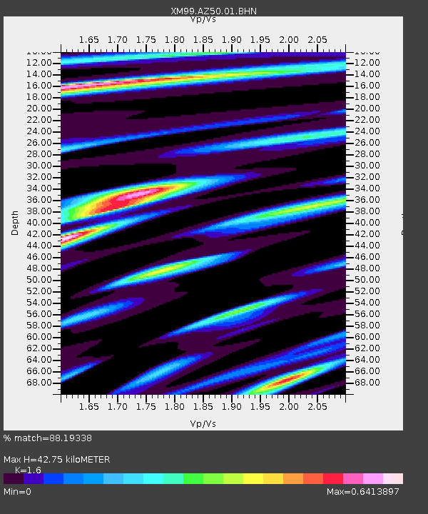
AZ50 Arizona50 - Earthquake Result Viewer
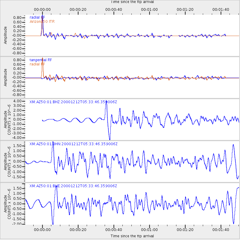
Earthquake location: South Of Panama
Earthquake latitude/longitude: 6.0/-82.7
Earthquake time(UTC): 2000/12/12 (347) 05:26:45 GMT
Earthquake Depth: 10 km
Earthquake Magnitude: 5.8 MB, 5.7 MS, 6.3 ME, 6.1 MW
Earthquake Catalog/Contributor: WHDF/NEIC
Network: XM Rio Grande Seismic Transect
Station: AZ50 Arizona50
Lat/Lon: 36.98 N/109.86 W
Elevation: 1469 m
Distance: 39.6 deg
Az: 324.95 deg
Baz: 134.5 deg
Ray Param: 0.07490672
Estimated Moho Depth: 42.75 km
Estimated Crust Vp/Vs: 1.60
Assumed Crust Vp: 6.476 km/s
Estimated Crust Vs: 4.047 km/s
Estimated Crust Poisson's Ratio: 0.18
Radial Match: 88.19338 %
Radial Bump: 320
Transverse Match: 60.50345 %
Transverse Bump: 400
SOD ConfigId: 27569
Insert Time: 2010-02-26 17:35:48.019 +0000
GWidth: 2.5
Max Bumps: 400
Tol: 0.001

Signal To Noise

ChannelStoNSTALTA
XM:AZ50:01:BHN:20001212T05:33:46.359006Z0.32248286.889762E-82.1364743E-7
XM:AZ50:01:BHE:20001212T05:33:46.359006Z0.70691861.8786841E-72.657568E-7
XM:AZ50:01:BHZ:20001212T05:33:46.359006Z1.32109243.3250583E-72.516901E-7
Arrivals
Ps4.3 SECOND
PpPs16 SECOND
PsPs/PpSs20 SECOND