You are here: Home > Network List > XM99 - Rio Grande Seismic Transect Stations List
> Station AZ50 Arizona50 > Earthquake Result Viewer
AZ50 Arizona50 - Earthquake Result Viewer
| Earthquake location: |
Western Honshu, Japan |
| Earthquake latitude/longitude: |
34.1/132.5 |
| Earthquake time(UTC): |
2001/03/24 (083) 06:27:53 GMT |
| Earthquake Depth: |
50 km |
| Earthquake Magnitude: |
6.4 MB, 6.5 MS, 6.8 MW, 6.4 ME |
| Earthquake Catalog/Contributor: |
WHDF/NEIC |
|
| Network: |
XM Rio Grande Seismic Transect |
| Station: |
AZ50 Arizona50 |
| Lat/Lon: |
36.98 N/109.86 W |
| Elevation: |
1469 m |
|
| Distance: |
88.5 deg |
| Az: |
45.223 deg |
| Baz: |
312.634 deg |
| Ray Param: |
0.042452067 |
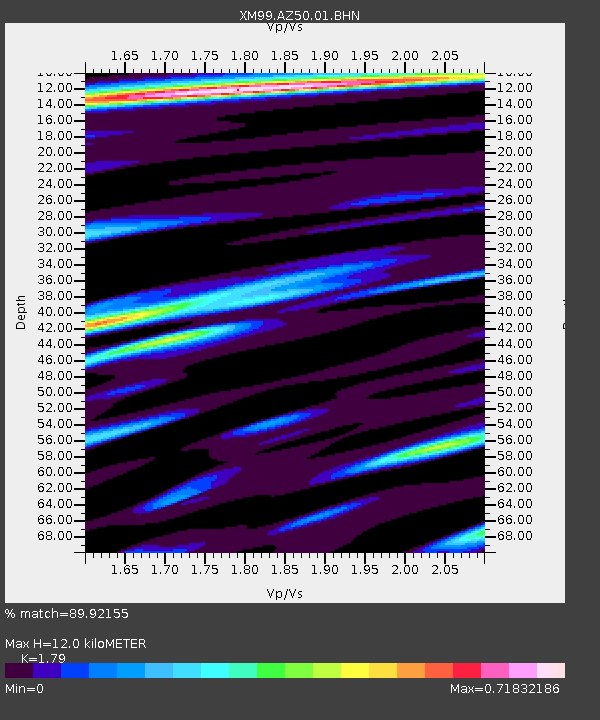
| Estimated Moho Depth: |
12.0 km |
| Estimated Crust Vp/Vs: |
1.79 |
| Assumed Crust Vp: |
6.476 km/s |
| Estimated Crust Vs: |
3.618 km/s |
| Estimated Crust Poisson's Ratio: |
0.27 |
|
| Radial Match: |
89.92155 % |
| Radial Bump: |
400 |
| Transverse Match: |
77.486626 % |
| Transverse Bump: |
400 |
| SOD ConfigId: |
4714 |
| Insert Time: |
2010-02-26 17:35:51.856 +0000 |
| GWidth: |
2.5 |
| Max Bumps: |
400 |
| Tol: |
0.001 |
|
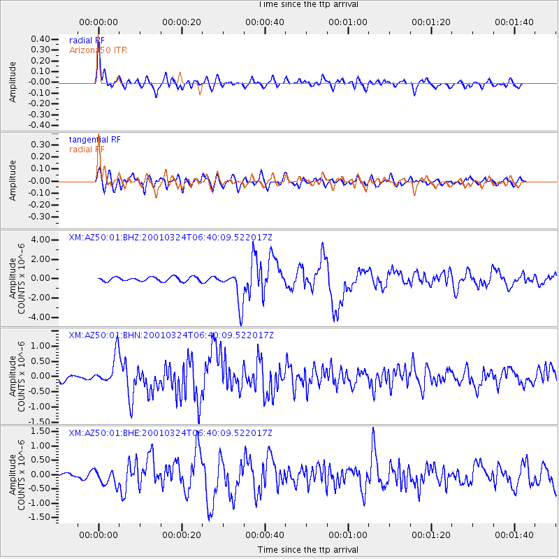
Signal To Noise
| Channel | StoN | STA | LTA |
| XM:AZ50:01:BHN:20010324T06:40:09.522017Z | 3.3202329 | 5.2453714E-7 | 1.5798204E-7 |
| XM:AZ50:01:BHE:20010324T06:40:09.522017Z | 3.9781275 | 2.790239E-7 | 7.013951E-8 |
| XM:AZ50:01:BHZ:20010324T06:40:09.522017Z | 8.462967 | 1.8697675E-6 | 2.2093523E-7 |
| Arrivals |
| Ps | 1.5 SECOND |
| PpPs | 5.1 SECOND |
| PsPs/PpSs | 6.6 SECOND |


