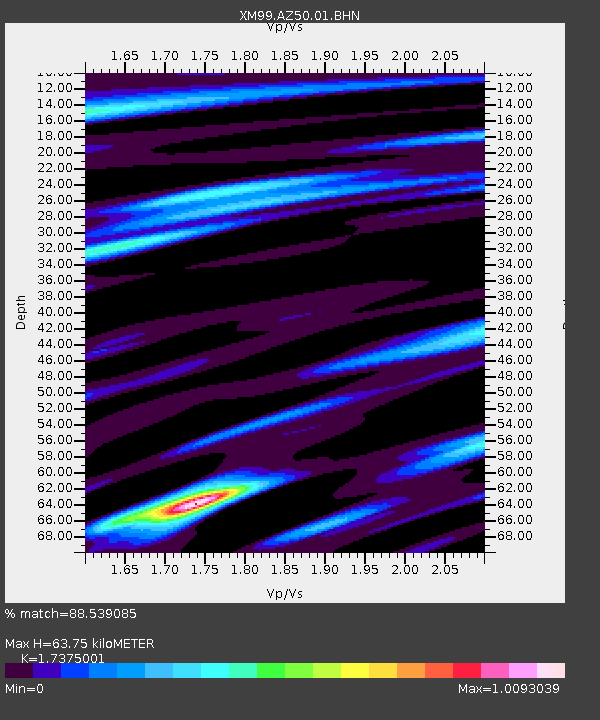
AZ50 Arizona50 - Earthquake Result Viewer
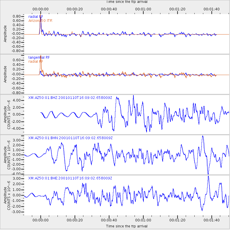
Earthquake location: Kodiak Island Region, Alaska
Earthquake latitude/longitude: 57.1/-153.2
Earthquake time(UTC): 2001/01/10 (010) 16:02:44 GMT
Earthquake Depth: 33 km
Earthquake Magnitude: 6.2 MB, 6.8 MS, 7.1 MW, 6.8 ML
Earthquake Catalog/Contributor: WHDF/NEIC
Network: XM Rio Grande Seismic Transect
Station: AZ50 Arizona50
Lat/Lon: 36.98 N/109.86 W
Elevation: 1469 m
Distance: 34.9 deg
Az: 106.306 deg
Baz: 319.12 deg
Ray Param: 0.077422835
Estimated Moho Depth: 63.75 km
Estimated Crust Vp/Vs: 1.74
Assumed Crust Vp: 6.476 km/s
Estimated Crust Vs: 3.727 km/s
Estimated Crust Poisson's Ratio: 0.25
Radial Match: 88.539085 %
Radial Bump: 341
Transverse Match: 68.010864 %
Transverse Bump: 400
SOD ConfigId: 16820
Insert Time: 2010-02-26 17:35:53.988 +0000
GWidth: 2.5
Max Bumps: 400
Tol: 0.001

Signal To Noise

ChannelStoNSTALTA
XM:AZ50:01:BHN:20010110T16:09:02.658009Z3.63274127.133518E-71.9636737E-7
XM:AZ50:01:BHE:20010110T16:09:02.658009Z2.0163973.6622998E-71.8162592E-7
XM:AZ50:01:BHZ:20010110T16:09:02.658009Z2.0231491.1075504E-65.4743884E-7
Arrivals
Ps7.9 SECOND
PpPs25 SECOND
PsPs/PpSs33 SECOND