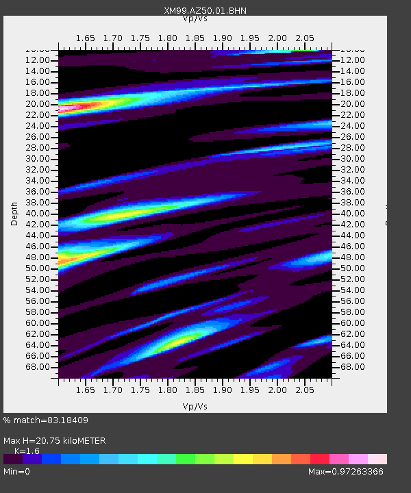
AZ50 Arizona50 - Earthquake Result Viewer

Earthquake location: Near Coast Of Central Chile
Earthquake latitude/longitude: -32.3/-71.5
Earthquake time(UTC): 2001/03/15 (074) 13:02:42 GMT
Earthquake Depth: 37 km
Earthquake Magnitude: 6.1 MB, 5.6 MS, 6.0 MW, 5.4 MD
Earthquake Catalog/Contributor: WHDF/NEIC
Network: XM Rio Grande Seismic Transect
Station: AZ50 Arizona50
Lat/Lon: 36.98 N/109.86 W
Elevation: 1469 m
Distance: 77.7 deg
Az: 329.418 deg
Baz: 147.458 deg
Ray Param: 0.05008239
Estimated Moho Depth: 20.75 km
Estimated Crust Vp/Vs: 1.60
Assumed Crust Vp: 6.476 km/s
Estimated Crust Vs: 4.047 km/s
Estimated Crust Poisson's Ratio: 0.18
Radial Match: 83.18409 %
Radial Bump: 379
Transverse Match: 71.62466 %
Transverse Bump: 400
SOD ConfigId: 4714
Insert Time: 2010-02-26 17:35:55.089 +0000
GWidth: 2.5
Max Bumps: 400
Tol: 0.001

Signal To Noise

ChannelStoNSTALTA
XM:AZ50:01:BHN:20010315T13:14:04.057998Z3.2079814.2530965E-71.3257859E-7
XM:AZ50:01:BHE:20010315T13:14:04.057998Z3.8963524.0388284E-71.0365666E-7
XM:AZ50:01:BHZ:20010315T13:14:04.057998Z7.7953511.2993886E-61.6668763E-7
Arrivals
Ps2.0 SECOND
PpPs8.1 SECOND
PsPs/PpSs10 SECOND