You are here: Home > Network List > XM99 - Rio Grande Seismic Transect Stations List
> Station AZ50 Arizona50 > Earthquake Result Viewer
AZ50 Arizona50 - Earthquake Result Viewer
| Earthquake location: |
Fiji Islands Region |
| Earthquake latitude/longitude: |
-18.1/-176.9 |
| Earthquake time(UTC): |
2001/04/28 (118) 04:49:53 GMT |
| Earthquake Depth: |
352 km |
| Earthquake Magnitude: |
6.2 MB, 6.8 MW, 6.8 MW |
| Earthquake Catalog/Contributor: |
WHDF/NEIC |
|
| Network: |
XM Rio Grande Seismic Transect |
| Station: |
AZ50 Arizona50 |
| Lat/Lon: |
36.98 N/109.86 W |
| Elevation: |
1469 m |
|
| Distance: |
83.6 deg |
| Az: |
47.922 deg |
| Baz: |
241.853 deg |
| Ray Param: |
0.045178004 |
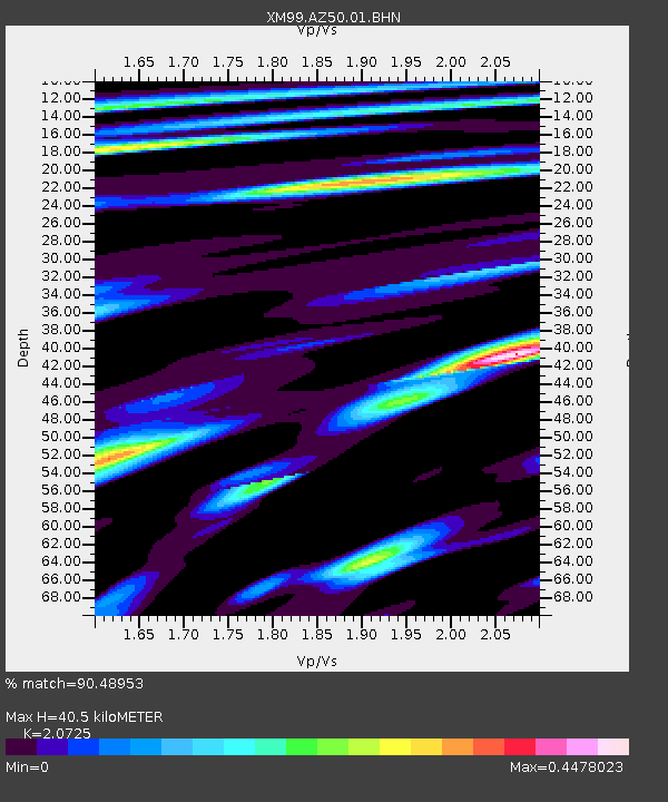
| Estimated Moho Depth: |
40.5 km |
| Estimated Crust Vp/Vs: |
2.07 |
| Assumed Crust Vp: |
6.476 km/s |
| Estimated Crust Vs: |
3.125 km/s |
| Estimated Crust Poisson's Ratio: |
0.35 |
|
| Radial Match: |
90.48953 % |
| Radial Bump: |
377 |
| Transverse Match: |
72.58321 % |
| Transverse Bump: |
400 |
| SOD ConfigId: |
4714 |
| Insert Time: |
2010-02-26 17:35:56.224 +0000 |
| GWidth: |
2.5 |
| Max Bumps: |
400 |
| Tol: |
0.001 |
|
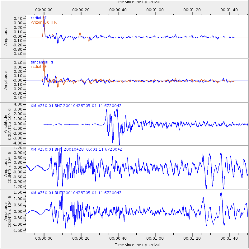
Signal To Noise
| Channel | StoN | STA | LTA |
| XM:AZ50:01:BHN:20010428T05:01:11.672004Z | 2.6662917 | 2.7332527E-7 | 1.0251139E-7 |
| XM:AZ50:01:BHE:20010428T05:01:11.672004Z | 4.919377 | 2.9524733E-7 | 6.001722E-8 |
| XM:AZ50:01:BHZ:20010428T05:01:11.672004Z | 16.7425 | 1.0490431E-6 | 6.26575E-8 |
| Arrivals |
| Ps | 6.9 SECOND |
| PpPs | 19 SECOND |
| PsPs/PpSs | 26 SECOND |


