You are here: Home > Network List > XM99 - Rio Grande Seismic Transect Stations List
> Station AZ50 Arizona50 > Earthquake Result Viewer
AZ50 Arizona50 - Earthquake Result Viewer
| Earthquake location: |
Southern Bolivia |
| Earthquake latitude/longitude: |
-20.9/-67.3 |
| Earthquake time(UTC): |
1999/09/15 (258) 03:01:24 GMT |
| Earthquake Depth: |
218 km |
| Earthquake Magnitude: |
6.0 MB, 6.4 MW, 6.4 MW |
| Earthquake Catalog/Contributor: |
WHDF/NEIC |
|
| Network: |
XM Rio Grande Seismic Transect |
| Station: |
AZ50 Arizona50 |
| Lat/Lon: |
36.98 N/109.86 W |
| Elevation: |
1469 m |
|
| Distance: |
70.2 deg |
| Az: |
324.837 deg |
| Baz: |
137.758 deg |
| Ray Param: |
0.054509602 |
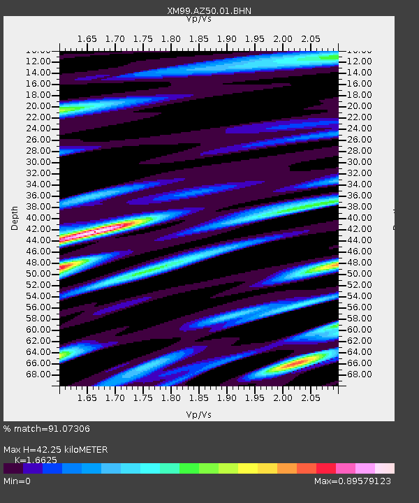
| Estimated Moho Depth: |
42.25 km |
| Estimated Crust Vp/Vs: |
1.66 |
| Assumed Crust Vp: |
6.476 km/s |
| Estimated Crust Vs: |
3.895 km/s |
| Estimated Crust Poisson's Ratio: |
0.22 |
|
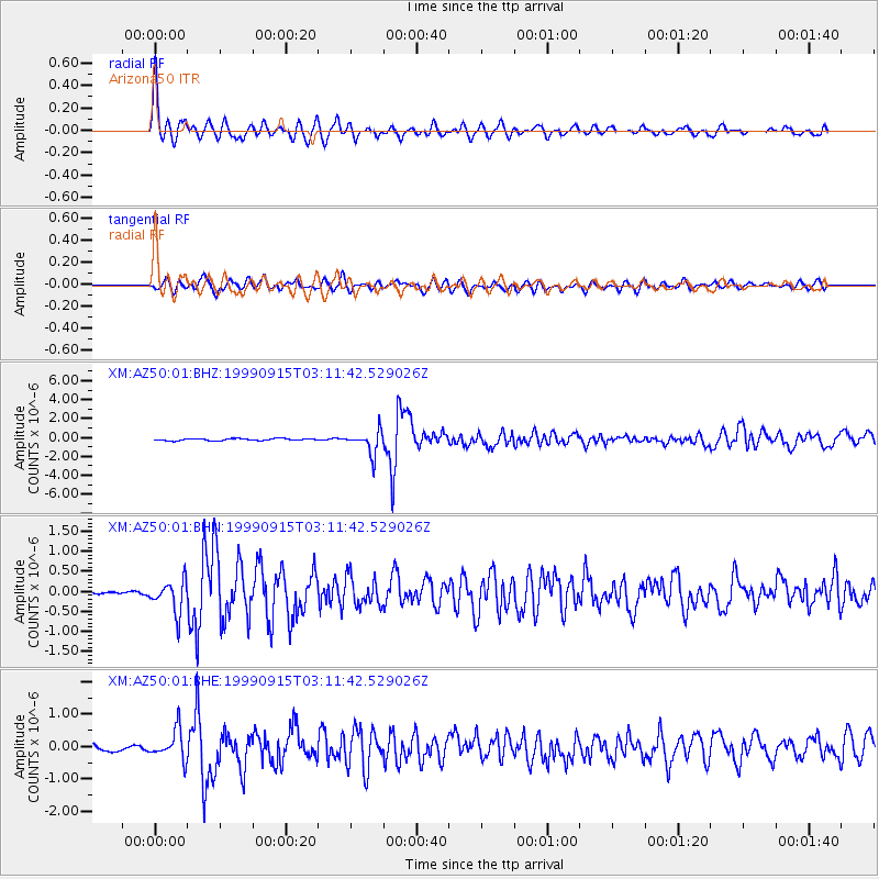
| Radial Match: |
91.07306 % |
| Radial Bump: |
400 |
| Transverse Match: |
83.46304 % |
| Transverse Bump: |
400 |
| SOD ConfigId: |
27569 |
| Insert Time: |
2010-02-26 17:35:57.376 +0000 |
| GWidth: |
2.5 |
| Max Bumps: |
400 |
| Tol: |
0.001 |
|
Signal To Noise
| Channel | StoN | STA | LTA |
| XM:AZ50:01:BHN:19990915T03:11:42.529026Z | 7.411227 | 3.9684545E-7 | 5.3546522E-8 |
| XM:AZ50:01:BHE:19990915T03:11:42.529026Z | 5.5235476 | 4.4546275E-7 | 8.064794E-8 |
| XM:AZ50:01:BHZ:19990915T03:11:42.529026Z | 11.100943 | 1.1937117E-6 | 1.0753246E-7 |
| Arrivals |
| Ps | 4.5 SECOND |
| PpPs | 17 SECOND |
| PsPs/PpSs | 21 SECOND |


