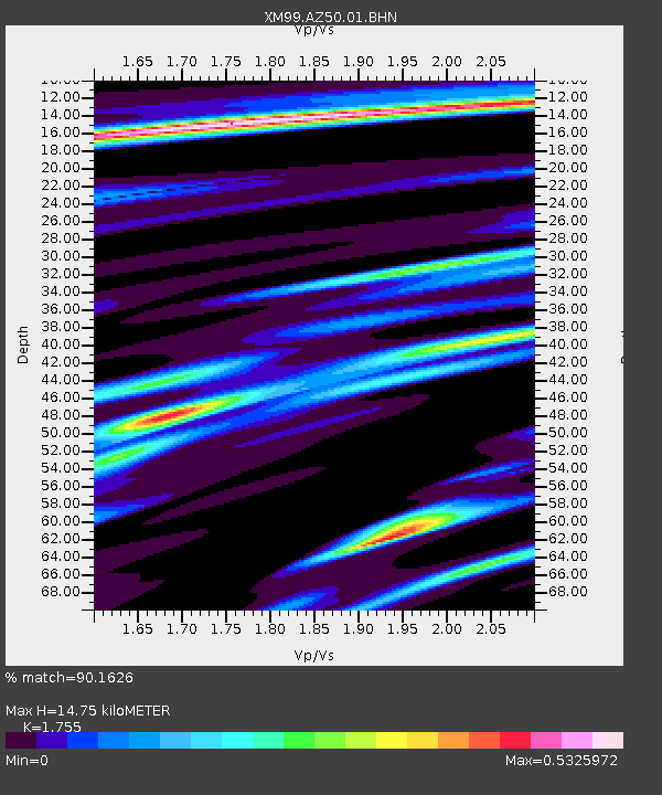
AZ50 Arizona50 - Earthquake Result Viewer
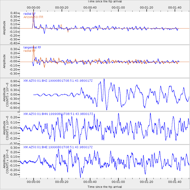
Earthquake location: Kermadec Islands, New Zealand
Earthquake latitude/longitude: -30.4/-177.8
Earthquake time(UTC): 1999/08/01 (213) 08:39:04 GMT
Earthquake Depth: 10 km
Earthquake Magnitude: 5.7 MB, 6.4 MS, 6.6 MW, 6.0 ME
Earthquake Catalog/Contributor: WHDF/NEIC
Network: XM Rio Grande Seismic Transect
Station: AZ50 Arizona50
Lat/Lon: 36.98 N/109.86 W
Elevation: 1469 m
Distance: 92.4 deg
Az: 47.985 deg
Baz: 233.308 deg
Ray Param: 0.041465994
Estimated Moho Depth: 14.75 km
Estimated Crust Vp/Vs: 1.75
Assumed Crust Vp: 6.476 km/s
Estimated Crust Vs: 3.69 km/s
Estimated Crust Poisson's Ratio: 0.26
Radial Match: 90.1626 %
Radial Bump: 400
Transverse Match: 80.42653 %
Transverse Bump: 400
SOD ConfigId: 27569
Insert Time: 2010-02-26 17:36:05.640 +0000
GWidth: 2.5
Max Bumps: 400
Tol: 0.001

Signal To Noise

ChannelStoNSTALTA
XM:AZ50:01:BHN:19990801T08:51:43.980017Z1.5741335.3898844E-83.4240337E-8
XM:AZ50:01:BHE:19990801T08:51:43.980017Z2.78184066.22453E-82.237558E-8
XM:AZ50:01:BHZ:19990801T08:51:43.980017Z4.3379771.8711118E-74.3133284E-8
Arrivals
Ps1.8 SECOND
PpPs6.1 SECOND
PsPs/PpSs7.9 SECOND