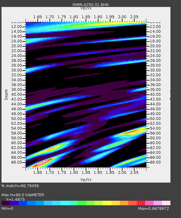
AZ50 Arizona50 - Earthquake Result Viewer
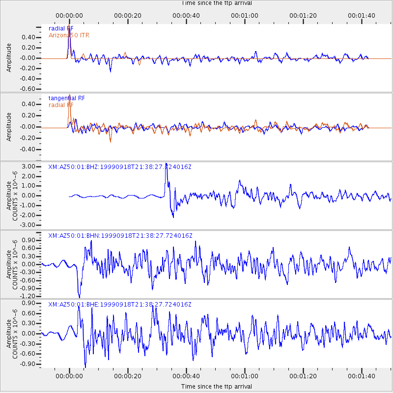
Earthquake location: Near East Coast Of Kamchatka
Earthquake latitude/longitude: 51.2/157.6
Earthquake time(UTC): 1999/09/18 (261) 21:28:33 GMT
Earthquake Depth: 60 km
Earthquake Magnitude: 5.9 MB, 5.6 MS, 6.2 MW, 6.0 MW
Earthquake Catalog/Contributor: WHDF/NEIC
Network: XM Rio Grande Seismic Transect
Station: AZ50 Arizona50
Lat/Lon: 36.98 N/109.86 W
Elevation: 1469 m
Distance: 63.7 deg
Az: 63.161 deg
Baz: 315.499 deg
Ray Param: 0.059258085
Estimated Moho Depth: 68.0 km
Estimated Crust Vp/Vs: 1.67
Assumed Crust Vp: 6.476 km/s
Estimated Crust Vs: 3.884 km/s
Estimated Crust Poisson's Ratio: 0.22
Radial Match: 88.79455 %
Radial Bump: 400
Transverse Match: 74.2246 %
Transverse Bump: 400
SOD ConfigId: 27569
Insert Time: 2010-02-26 17:36:06.701 +0000
GWidth: 2.5
Max Bumps: 400
Tol: 0.001

Signal To Noise

ChannelStoNSTALTA
XM:AZ50:01:BHN:19990918T21:38:27.724016Z7.4262154.8538965E-76.536165E-8
XM:AZ50:01:BHE:19990918T21:38:27.724016Z3.23457673.2610944E-71.00819825E-7
XM:AZ50:01:BHZ:19990918T21:38:27.724016Z12.8093271.2535098E-69.785915E-8
Arrivals
Ps7.3 SECOND
PpPs27 SECOND
PsPs/PpSs34 SECOND