You are here: Home > Network List > XM99 - Rio Grande Seismic Transect Stations List
> Station AZ50 Arizona50 > Earthquake Result Viewer
AZ50 Arizona50 - Earthquake Result Viewer
| Earthquake location: |
Kodiak Island Region, Alaska |
| Earthquake latitude/longitude: |
57.4/-154.5 |
| Earthquake time(UTC): |
1999/12/06 (340) 23:12:33 GMT |
| Earthquake Depth: |
66 km |
| Earthquake Magnitude: |
6.8 MB, 7.0 MW, 7.0 ML |
| Earthquake Catalog/Contributor: |
WHDF/NEIC |
|
| Network: |
XM Rio Grande Seismic Transect |
| Station: |
AZ50 Arizona50 |
| Lat/Lon: |
36.98 N/109.86 W |
| Elevation: |
1469 m |
|
| Distance: |
35.7 deg |
| Az: |
105.421 deg |
| Baz: |
319.351 deg |
| Ray Param: |
0.07689294 |
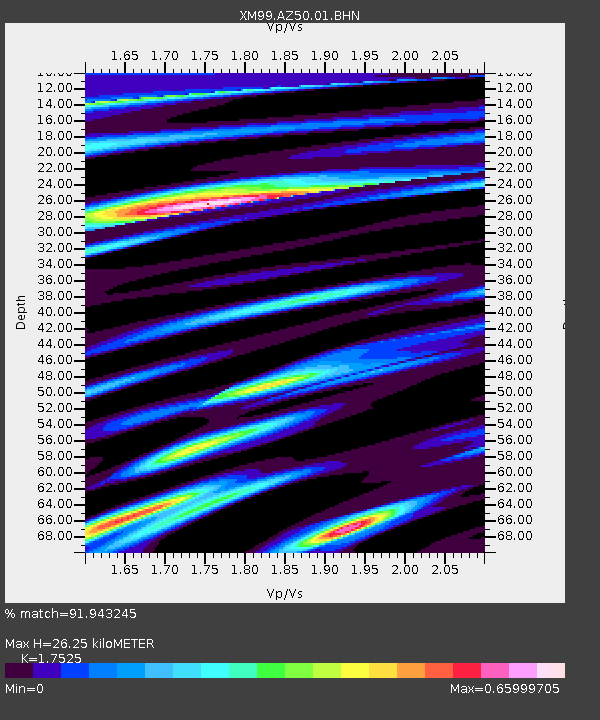
| Estimated Moho Depth: |
26.25 km |
| Estimated Crust Vp/Vs: |
1.75 |
| Assumed Crust Vp: |
6.476 km/s |
| Estimated Crust Vs: |
3.695 km/s |
| Estimated Crust Poisson's Ratio: |
0.26 |
|
| Radial Match: |
91.943245 % |
| Radial Bump: |
352 |
| Transverse Match: |
83.64337 % |
| Transverse Bump: |
400 |
| SOD ConfigId: |
27569 |
| Insert Time: |
2010-02-26 17:36:08.427 +0000 |
| GWidth: |
2.5 |
| Max Bumps: |
400 |
| Tol: |
0.001 |
|
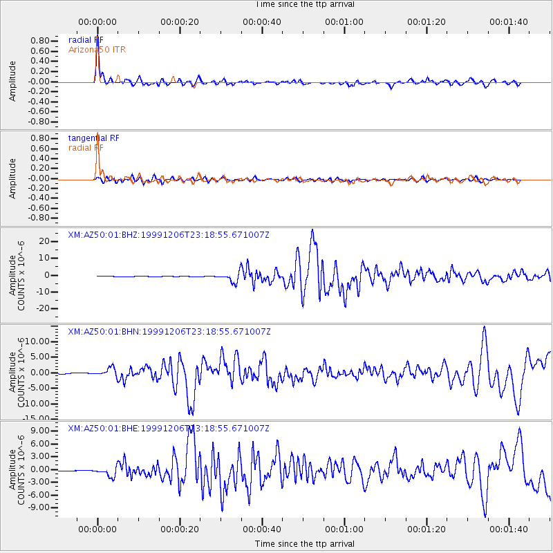
Signal To Noise
| Channel | StoN | STA | LTA |
| XM:AZ50:01:BHN:19991206T23:18:55.671007Z | 7.1972666 | 1.4532711E-6 | 2.0191986E-7 |
| XM:AZ50:01:BHE:19991206T23:18:55.671007Z | 7.4352455 | 1.2026342E-6 | 1.6174774E-7 |
| XM:AZ50:01:BHZ:19991206T23:18:55.671007Z | 15.851233 | 3.1563768E-6 | 1.99125E-7 |
| Arrivals |
| Ps | 3.3 SECOND |
| PpPs | 10 SECOND |
| PsPs/PpSs | 14 SECOND |


