You are here: Home > Network List > XM99 - Rio Grande Seismic Transect Stations List
> Station AZ50 Arizona50 > Earthquake Result Viewer
AZ50 Arizona50 - Earthquake Result Viewer
| Earthquake location: |
Tonga Islands |
| Earthquake latitude/longitude: |
-15.9/-174.0 |
| Earthquake time(UTC): |
1999/12/07 (341) 21:29:49 GMT |
| Earthquake Depth: |
138 km |
| Earthquake Magnitude: |
6.2 MB, 6.4 MW, 6.4 MW |
| Earthquake Catalog/Contributor: |
WHDF/NEIC |
|
| Network: |
XM Rio Grande Seismic Transect |
| Station: |
AZ50 Arizona50 |
| Lat/Lon: |
36.98 N/109.86 W |
| Elevation: |
1469 m |
|
| Distance: |
80.0 deg |
| Az: |
47.016 deg |
| Baz: |
241.516 deg |
| Ray Param: |
0.048232816 |
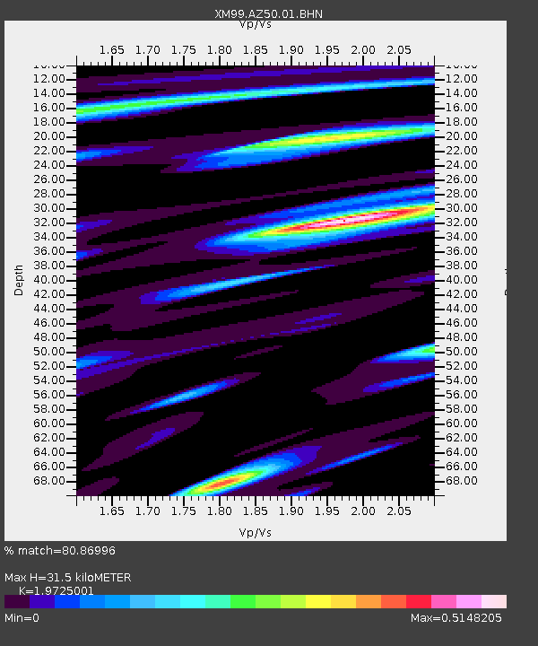
| Estimated Moho Depth: |
31.5 km |
| Estimated Crust Vp/Vs: |
1.97 |
| Assumed Crust Vp: |
6.476 km/s |
| Estimated Crust Vs: |
3.283 km/s |
| Estimated Crust Poisson's Ratio: |
0.33 |
|
| Radial Match: |
80.86996 % |
| Radial Bump: |
400 |
| Transverse Match: |
69.824875 % |
| Transverse Bump: |
400 |
| SOD ConfigId: |
27569 |
| Insert Time: |
2010-02-26 17:36:10.577 +0000 |
| GWidth: |
2.5 |
| Max Bumps: |
400 |
| Tol: |
0.001 |
|
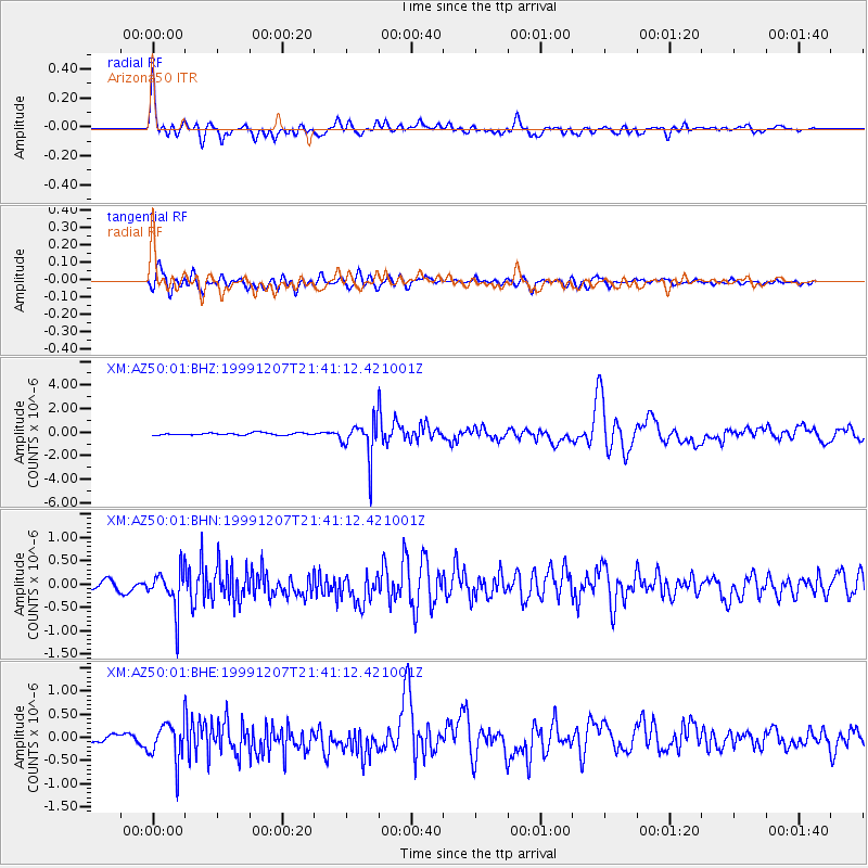
Signal To Noise
| Channel | StoN | STA | LTA |
| XM:AZ50:01:BHN:19991207T21:41:12.421001Z | 3.3131754 | 4.3720115E-7 | 1.3195834E-7 |
| XM:AZ50:01:BHE:19991207T21:41:12.421001Z | 4.228817 | 4.1807775E-7 | 9.886399E-8 |
| XM:AZ50:01:BHZ:19991207T21:41:12.421001Z | 16.580078 | 1.5796373E-6 | 9.5273215E-8 |
| Arrivals |
| Ps | 4.9 SECOND |
| PpPs | 14 SECOND |
| PsPs/PpSs | 19 SECOND |


