You are here: Home > Network List > XK01 - Reflections under the Scottish Highlands Stations List
> Station BASS Bettyhill Array, South Station > Earthquake Result Viewer
BASS Bettyhill Array, South Station - Earthquake Result Viewer
| Earthquake location: |
Southern Alaska |
| Earthquake latitude/longitude: |
59.0/-155.1 |
| Earthquake time(UTC): |
2001/07/28 (209) 07:32:43 GMT |
| Earthquake Depth: |
131 km |
| Earthquake Magnitude: |
5.7 MB, 5.7 MS, 6.6 MW, 6.2 ME |
| Earthquake Catalog/Contributor: |
WHDF/NEIC |
|
| Network: |
XK Reflections under the Scottish Highlands |
| Station: |
BASS Bettyhill Array, South Station |
| Lat/Lon: |
58.48 N/4.20 W |
| Elevation: |
96 m |
|
| Distance: |
60.6 deg |
| Az: |
17.043 deg |
| Baz: |
343.228 deg |
| Ray Param: |
0.06102714 |
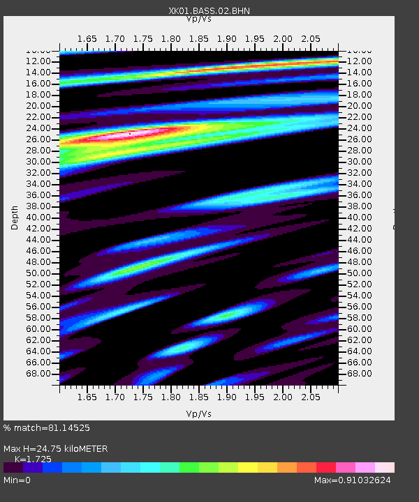
| Estimated Moho Depth: |
24.75 km |
| Estimated Crust Vp/Vs: |
1.73 |
| Assumed Crust Vp: |
6.24 km/s |
| Estimated Crust Vs: |
3.617 km/s |
| Estimated Crust Poisson's Ratio: |
0.25 |
|
| Radial Match: |
81.14525 % |
| Radial Bump: |
400 |
| Transverse Match: |
54.248905 % |
| Transverse Bump: |
400 |
| SOD ConfigId: |
16820 |
| Insert Time: |
2010-03-09 22:57:27.571 +0000 |
| GWidth: |
2.5 |
| Max Bumps: |
400 |
| Tol: |
0.001 |
|

Signal To Noise
| Channel | StoN | STA | LTA |
| XK:BASS:02:BHN:20010728T07:42:09.194021Z | 0.81519693 | 8.658462E-8 | 1.06213136E-7 |
| XK:BASS:02:BHE:20010728T07:42:09.194021Z | 1.1254531 | 8.0494445E-8 | 7.152182E-8 |
| XK:BASS:02:BHZ:20010728T07:42:09.194021Z | 0.9129652 | 1.5038269E-7 | 1.6471898E-7 |
| Arrivals |
| Ps | 3.0 SECOND |
| PpPs | 10 SECOND |
| PsPs/PpSs | 13 SECOND |


