
Station XK BASS - Bettyhill Array, South Station
Network: XK01 - Reflections under the Scottish Highlands
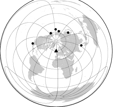
Nearby stations (2 deg radius)
| Station | Name | (Lat, Lon) | Start / End | Elevation |
| BASS | Bettyhill Array, South Station | (58.48, -4.20) | 2001-07-11 / 2003-12-31 | 0.1 km |
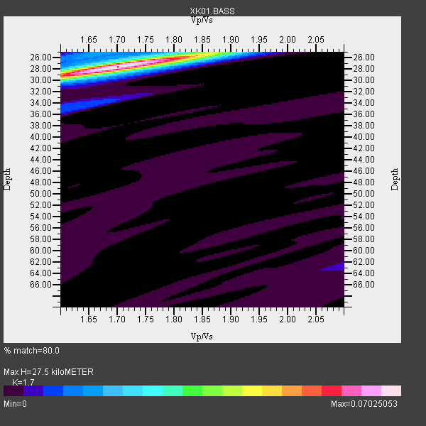
| Crust2 Type: | C2,continental shelf, 1 km seds. |
| Thickness Estimate: | 28 km |
| Thickness StdDev: | 0.7 km |
| Vp/Vs Estimate: | 1.70 |
| Vp/Vs StdDev: | 0.04 |
| Vs Estimate: | 3.671 km/s |
| Poisson's Ratio: | 0.24 |
| Peak Value: | 0.07 |
| Assumed Vp: | 6.24 km/s |
| Ps Weight: | 0.33333334 |
| PpPs Weight: | 0.33333334 |
| PsPs Weight: | 0.33333328 |
| Residual Complexity: | 0.183 |
| Nearby stations H: | +- |
| (2.0 deg) Vp/Vs: | +- |
2 with match > 90% ( 33.333332 %) and 6 with match > 80% ( 100.0 %) out of 6.
Download stack as xyz text file.
Azimuth Distribution of Events:
Prior Results for this Station
| Study | Thickness | Vp/Vs | Vp | Vs | Poissons Ratio | Extra |
| EARS | 28 km | 1.70 | 6.24 km/s | 3.671 km/s | 0.24 | |
| Crust2.0 | 30 km | 1.80 | 6.24 km/s | 3.467 km/s | 0.28 | C2,continental shelf, 1 km seds. |
| Global Maxima | 28 km | 1.70 | 6.24 km/s | 3.671 km/s | 0.24 | amp=0.07025053 |
| Local Maxima 1 | 25 km | 1.84 | 6.24 km/s | 3.387 km/s | 0.29 | amp=0.019731106 |
| Local Maxima 2 | 29 km | 1.60 | 6.24 km/s | 3.9 km/s | 0.18 | amp=0.011647447 |
| Local Maxima 3 | 25 km | 1.65 | 6.24 km/s | 3.776 km/s | 0.21 | amp=0.009880026 |
| Local Maxima 4 | 34 km | 1.64 | 6.24 km/s | 3.811 km/s | 0.20 | amp=0.0096996715 |
| Predicted Arrivals for vertical incidence (zero ray parameter) | |
| Ps | 3.08 SECOND |
| PpPs | 11.90 SECOND |
| PsPs/PpSs | 14.98 SECOND |
Events Processed for this Station
Download zip of receiver functions as SAC
Plot maxima for each earthquake.
Events Used in the Stack
(6 events)| Radial Match | Distance | Baz | FERegion | Time | Lat/Lon | Depth | Magnitude |
| 95.928535 | 79.2 deg | 288.189 deg | Near Coast Of Jalisco, Mexico | 2003/01/22 02:06:34 GMT | (18.8, -104.1) | 24 km | 6.5 MB, 7.6 MS, 7.6 MW, 7.4 MW |
| 95.281685 | 70.6 deg | 358.549 deg | Rat Islands, Aleutian Islands | 2003/03/17 16:36:17 GMT | (51.3, 178.0) | 33 km | 5.9 MB, 6.7 MS, 7.0 MW, 7.0 MW |
| 89.45835 | 71.5 deg | 32.798 deg | E. Russia-N.E. China Border Reg. | 2002/06/28 17:19:30 GMT | (43.8, 130.7) | 566 km | 6.7 MB, 7.3 MW, 7.3 MW |
| 83.063995 | 82.8 deg | 77.029 deg | Andaman Islands, India Region | 2002/09/13 22:28:29 GMT | (13.0, 93.1) | 21 km | 6.2 MB, 6.7 MS, 6.5 MW, 6.5 MW |
| 81.14525 | 60.6 deg | 343.228 deg | Southern Alaska | 2001/07/28 07:32:43 GMT | (59.0, -155.1) | 131 km | 5.7 MB, 5.7 MS, 6.6 MW, 6.2 ME |
| 80.15381 | 65.2 deg | 7.348 deg | Near East Coast Of Kamchatka | 2001/08/02 23:41:06 GMT | (56.3, 163.8) | 14 km | 5.9 MB, 6.2 MS, 6.3 MW, 6.2 ME |
Losers
(0 events)| Radial Match | Distance | Baz | FERegion | Time | Lat/Lon | Depth | Magnitude | Reason |
