You are here: Home > Network List > XK01 - Reflections under the Scottish Highlands Stations List
> Station BASS Bettyhill Array, South Station > Earthquake Result Viewer
BASS Bettyhill Array, South Station - Earthquake Result Viewer
| Earthquake location: |
E. Russia-N.E. China Border Reg. |
| Earthquake latitude/longitude: |
43.8/130.7 |
| Earthquake time(UTC): |
2002/06/28 (179) 17:19:30 GMT |
| Earthquake Depth: |
566 km |
| Earthquake Magnitude: |
6.7 MB, 7.3 MW, 7.3 MW |
| Earthquake Catalog/Contributor: |
WHDF/NEIC |
|
| Network: |
XK Reflections under the Scottish Highlands |
| Station: |
BASS Bettyhill Array, South Station |
| Lat/Lon: |
58.48 N/4.20 W |
| Elevation: |
96 m |
|
| Distance: |
71.5 deg |
| Az: |
336.879 deg |
| Baz: |
32.798 deg |
| Ray Param: |
0.052399755 |
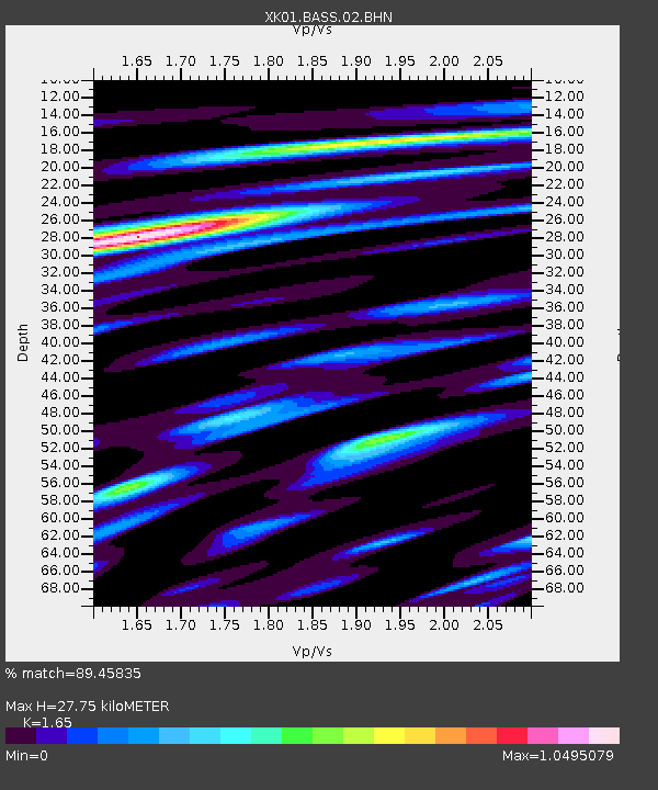
| Estimated Moho Depth: |
27.75 km |
| Estimated Crust Vp/Vs: |
1.65 |
| Assumed Crust Vp: |
6.24 km/s |
| Estimated Crust Vs: |
3.782 km/s |
| Estimated Crust Poisson's Ratio: |
0.21 |
|
| Radial Match: |
89.45835 % |
| Radial Bump: |
400 |
| Transverse Match: |
88.412476 % |
| Transverse Bump: |
400 |
| SOD ConfigId: |
16820 |
| Insert Time: |
2010-03-09 22:57:31.070 +0000 |
| GWidth: |
2.5 |
| Max Bumps: |
400 |
| Tol: |
0.001 |
|

Signal To Noise
| Channel | StoN | STA | LTA |
| XK:BASS:02:BHN:20020628T17:29:23.152019Z | 3.188668 | 1.1591585E-6 | 3.6352438E-7 |
| XK:BASS:02:BHE:20020628T17:29:23.152019Z | 2.4013736 | 1.1265912E-6 | 4.691445E-7 |
| XK:BASS:02:BHZ:20020628T17:29:23.152019Z | 5.73402 | 4.140719E-6 | 7.221319E-7 |
| Arrivals |
| Ps | 3.0 SECOND |
| PpPs | 11 SECOND |
| PsPs/PpSs | 14 SECOND |


