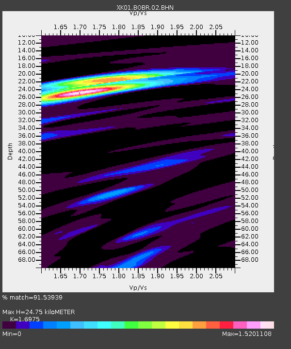
BOBR Bonar Bridge - Earthquake Result Viewer

Earthquake location: Western Iran
Earthquake latitude/longitude: 35.6/49.0
Earthquake time(UTC): 2002/06/22 (173) 02:58:21 GMT
Earthquake Depth: 10 km
Earthquake Magnitude: 6.2 MB, 6.4 MS, 6.5 MW, 6.5 MW
Earthquake Catalog/Contributor: WHDF/NEIC
Network: XK Reflections under the Scottish Highlands
Station: BOBR Bonar Bridge
Lat/Lon: 57.91 N/4.33 W
Elevation: 219 m
Distance: 41.4 deg
Az: 319.652 deg
Baz: 98.819 deg
Ray Param: 0.073798575
Estimated Moho Depth: 24.75 km
Estimated Crust Vp/Vs: 1.70
Assumed Crust Vp: 6.276 km/s
Estimated Crust Vs: 3.697 km/s
Estimated Crust Poisson's Ratio: 0.23
Radial Match: 91.53939 %
Radial Bump: 324
Transverse Match: 68.58803 %
Transverse Bump: 400
SOD ConfigId: 16820
Insert Time: 2010-03-09 22:57:58.048 +0000
GWidth: 2.5
Max Bumps: 400
Tol: 0.001

Signal To Noise

ChannelStoNSTALTA
XK:BOBR:02:BHN:20020622T03:05:37.055005Z1.57091963.7110948E-72.3623709E-7
XK:BOBR:02:BHE:20020622T03:05:37.055005Z5.11504361.5196933E-62.971027E-7
XK:BOBR:02:BHZ:20020622T03:05:37.055005Z5.8157972.174522E-63.738992E-7
Arrivals
Ps2.9 SECOND
PpPs9.9 SECOND
PsPs/PpSs13 SECOND