
Station XK BOBR - Bonar Bridge
Network: XK01 - Reflections under the Scottish Highlands
Nearby stations (2 deg radius)
| Station | Name | (Lat, Lon) | Start / End | Elevation |
| BOBR | Bonar Bridge | (57.91, -4.33) | 2001-07-01 / 2003-12-31 | 0.2 km |
| Crust2 Type: | M5,extended crust, 0.5 km seds. |
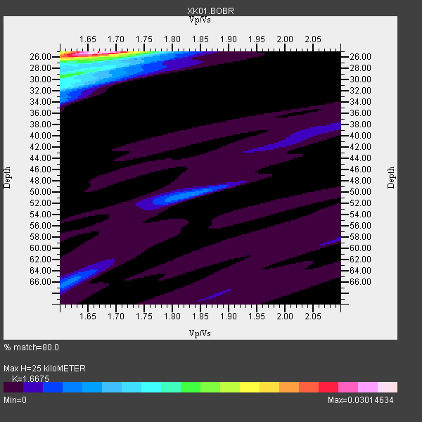
| Thickness Estimate: | 25 km |
| Thickness StdDev: | 2.1 km |
| Vp/Vs Estimate: | 1.67 |
| Vp/Vs StdDev: | 0.03 |
| Vs Estimate: | 3.764 km/s |
| Poisson's Ratio: | 0.22 |
| Peak Value: | 0.03 |
| Assumed Vp: | 6.276 km/s |
| Ps Weight: | 0.33333334 |
| PpPs Weight: | 0.33333334 |
| PsPs Weight: | 0.33333328 |
| Residual Complexity: | 0.537 |
| Nearby stations H: | +- |
| (2.0 deg) Vp/Vs: | +- |
5 with match > 90% ( 50.0 %) and 10 with match > 80% ( 100.0 %) out of 10.
Download stack as xyz text file.
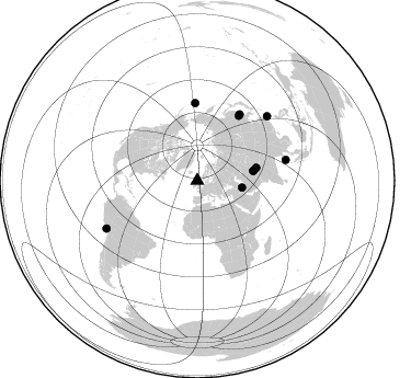
Azimuth Distribution of Events:
Prior Results for this Station
| Study | Thickness | Vp/Vs | Vp | Vs | Poissons Ratio | Extra |
| EARS | 25 km | 1.67 | 6.276 km/s | 3.764 km/s | 0.22 | |
| Crust2.0 | 31 km | 1.78 | 6.276 km/s | 3.529 km/s | 0.27 | M5,extended crust, 0.5 km seds. |
| Global Maxima | 25 km | 1.67 | 6.276 km/s | 3.764 km/s | 0.22 | amp=0.03014634 |
| Local Maxima 1 | 31 km | 1.60 | 6.276 km/s | 3.922 km/s | 0.18 | amp=0.011824678 |
| Local Maxima 2 | 30 km | 1.60 | 6.276 km/s | 3.916 km/s | 0.18 | amp=0.008681424 |
| Local Maxima 3 | 26 km | 1.72 | 6.276 km/s | 3.654 km/s | 0.24 | amp=0.0061158133 |
| Local Maxima 4 | 50 km | 1.82 | 6.276 km/s | 3.444 km/s | 0.28 | amp=0.0056210076 |
| Predicted Arrivals for vertical incidence (zero ray parameter) | |
| Ps | 2.66 SECOND |
| PpPs | 10.63 SECOND |
| PsPs/PpSs | 13.29 SECOND |
Events Processed for this Station
Download zip of receiver functions as SAC
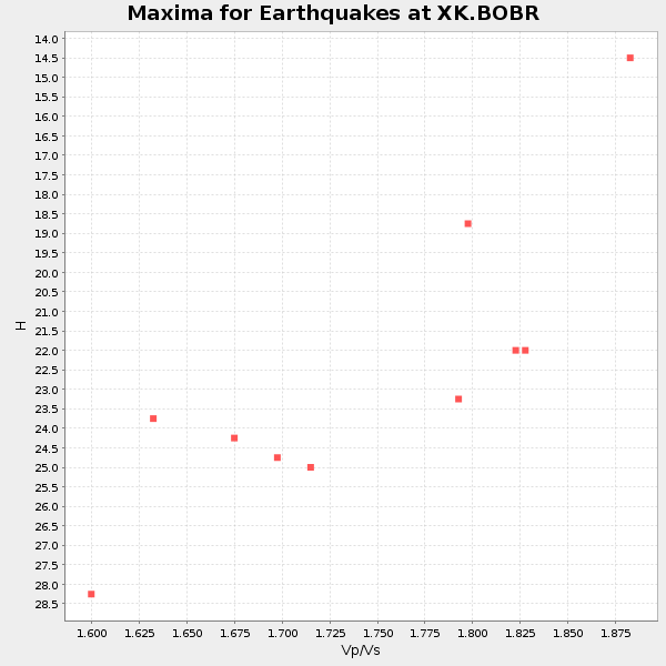
Plot maxima for each earthquake.
Events Used in the Stack
(10 events)| Radial Match | Distance | Baz | FERegion | Time | Lat/Lon | Depth | Magnitude |
| 97.2488 | 93.5 deg | 242.206 deg | Near Coast Of Peru | 2001/07/07 09:38:43 GMT | (-17.5, -72.1) | 33 km | 6.6 MB, 7.3 MS, 7.6 MW, 7.5 ME |
| 95.16128 | 71.2 deg | 358.468 deg | Rat Islands, Aleutian Islands | 2003/03/17 16:36:17 GMT | (51.3, 178.0) | 33 km | 5.9 MB, 6.7 MS, 7.0 MW, 7.0 MW |
| 94.280106 | 52.2 deg | 80.058 deg | Hindu Kush Region, Afghanistan | 2002/03/03 12:08:07 GMT | (36.4, 70.4) | 209 km | 6.3 MB |
| 93.64383 | 52.2 deg | 79.963 deg | Hindu Kush Region, Afghanistan | 2002/03/03 12:08:19 GMT | (36.5, 70.5) | 226 km | 6.6 MB, 7.4 MW, 7.3 MW |
| 91.53939 | 41.4 deg | 98.819 deg | Western Iran | 2002/06/22 02:58:21 GMT | (35.6, 49.0) | 10 km | 6.2 MB, 6.4 MS, 6.5 MW, 6.5 MW |
| 89.89743 | 72.0 deg | 32.606 deg | E. Russia-N.E. China Border Reg. | 2002/06/28 17:19:30 GMT | (43.8, 130.7) | 566 km | 6.7 MB, 7.3 MW, 7.3 MW |
| 86.98344 | 70.8 deg | 32.664 deg | Northeastern China | 2002/09/15 08:39:32 GMT | (44.8, 129.9) | 586 km | 5.8 MB, 6.4 MW, 6.4 MW |
| 85.13987 | 86.8 deg | 47.278 deg | Taiwan Region | 2002/03/31 06:52:50 GMT | (24.3, 122.2) | 33 km | 6.4 MB, 7.4 MS, 7.1 MW, 7.1 MW |
| 81.63522 | 83.0 deg | 76.852 deg | Andaman Islands, India Region | 2002/09/13 22:28:29 GMT | (13.0, 93.1) | 21 km | 6.2 MB, 6.7 MS, 6.5 MW, 6.5 MW |
| 80.18757 | 55.1 deg | 77.73 deg | Northwestern Kashmir | 2002/11/20 21:32:30 GMT | (35.4, 74.5) | 33 km | 5.7 MB, 6.5 MS, 6.4 MW, 6.0 MW |
Losers
(0 events)| Radial Match | Distance | Baz | FERegion | Time | Lat/Lon | Depth | Magnitude | Reason |
