You are here: Home > Network List > XK01 - Reflections under the Scottish Highlands Stations List
> Station BOBR Bonar Bridge > Earthquake Result Viewer
BOBR Bonar Bridge - Earthquake Result Viewer
| Earthquake location: |
Hindu Kush Region, Afghanistan |
| Earthquake latitude/longitude: |
36.5/70.5 |
| Earthquake time(UTC): |
2002/03/03 (062) 12:08:19 GMT |
| Earthquake Depth: |
226 km |
| Earthquake Magnitude: |
6.6 MB, 7.4 MW, 7.3 MW |
| Earthquake Catalog/Contributor: |
WHDF/NEIC |
|
| Network: |
XK Reflections under the Scottish Highlands |
| Station: |
BOBR Bonar Bridge |
| Lat/Lon: |
57.91 N/4.33 W |
| Elevation: |
219 m |
|
| Distance: |
52.2 deg |
| Az: |
319.284 deg |
| Baz: |
79.963 deg |
| Ray Param: |
0.06612001 |
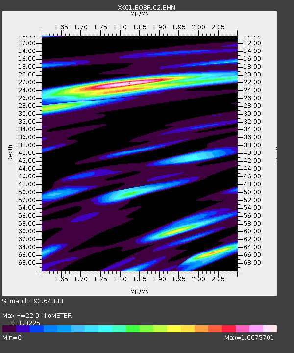
| Estimated Moho Depth: |
22.0 km |
| Estimated Crust Vp/Vs: |
1.82 |
| Assumed Crust Vp: |
6.276 km/s |
| Estimated Crust Vs: |
3.444 km/s |
| Estimated Crust Poisson's Ratio: |
0.28 |
|
| Radial Match: |
93.64383 % |
| Radial Bump: |
379 |
| Transverse Match: |
79.369354 % |
| Transverse Bump: |
400 |
| SOD ConfigId: |
16820 |
| Insert Time: |
2010-03-09 22:58:01.592 +0000 |
| GWidth: |
2.5 |
| Max Bumps: |
400 |
| Tol: |
0.001 |
|

Signal To Noise
| Channel | StoN | STA | LTA |
| XK:BOBR:02:BHN:20020303T12:16:36.405009Z | 1.7322878 | 2.070293E-6 | 1.1951207E-6 |
| XK:BOBR:02:BHE:20020303T12:16:36.405009Z | 8.105798 | 1.0030339E-5 | 1.2374277E-6 |
| XK:BOBR:02:BHZ:20020303T12:16:36.405009Z | 7.630495 | 1.7904656E-5 | 2.3464606E-6 |
| Arrivals |
| Ps | 3.0 SECOND |
| PpPs | 9.4 SECOND |
| PsPs/PpSs | 12 SECOND |


