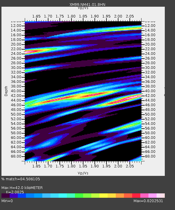
NM41 NewMexico41 - Earthquake Result Viewer
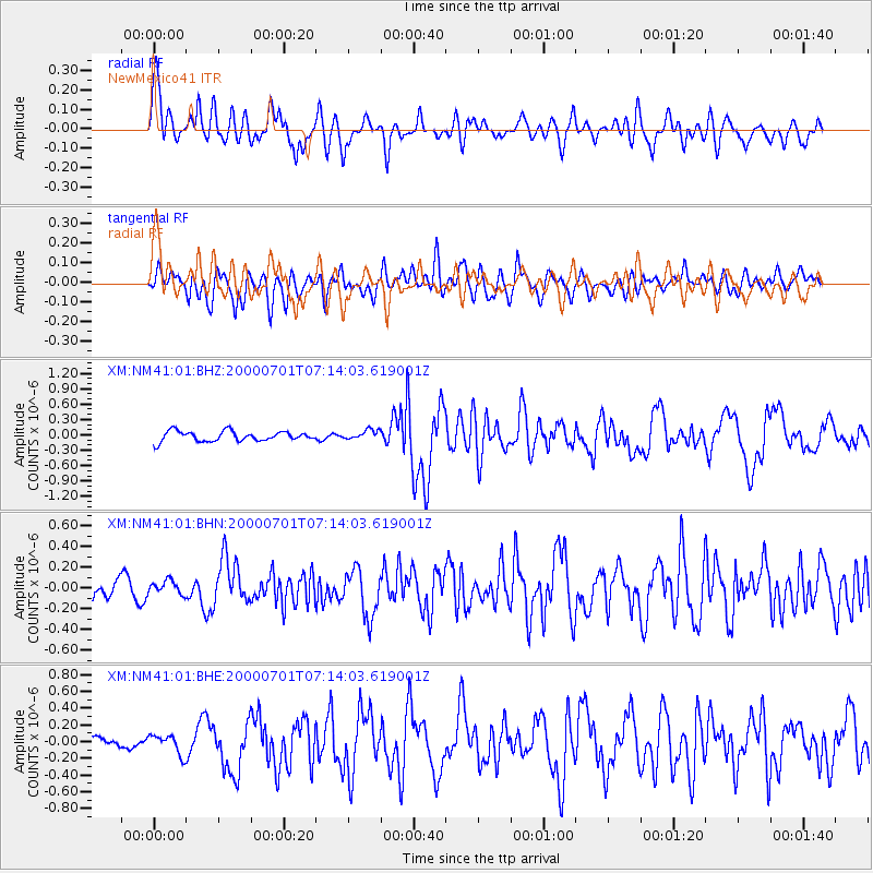
Earthquake location: Near S. Coast Of Honshu, Japan
Earthquake latitude/longitude: 34.2/139.1
Earthquake time(UTC): 2000/07/01 (183) 07:01:55 GMT
Earthquake Depth: 10 km
Earthquake Magnitude: 6.0 MB, 6.1 MS, 6.2 MW, 6.2 MW
Earthquake Catalog/Contributor: WHDF/NEIC
Network: XM Rio Grande Seismic Transect
Station: NM41 NewMexico41
Lat/Lon: 36.04 N/108.57 W
Elevation: 1718 m
Distance: 85.8 deg
Az: 48.757 deg
Baz: 309.762 deg
Ray Param: 0.04449655
Estimated Moho Depth: 42.0 km
Estimated Crust Vp/Vs: 2.08
Assumed Crust Vp: 6.476 km/s
Estimated Crust Vs: 3.11 km/s
Estimated Crust Poisson's Ratio: 0.35
Radial Match: 84.586105 %
Radial Bump: 400
Transverse Match: 65.07517 %
Transverse Bump: 400
SOD ConfigId: 3744
Insert Time: 2010-02-26 17:36:12.324 +0000
GWidth: 2.5
Max Bumps: 400
Tol: 0.001

Signal To Noise

ChannelStoNSTALTA
XM:NM41:01:BHN:20000701T07:14:03.619001Z0.581504176.4033514E-81.10117035E-7
XM:NM41:01:BHE:20000701T07:14:03.619001Z1.55824211.18629174E-77.6130135E-8
XM:NM41:01:BHZ:20000701T07:14:03.619001Z0.947833069.222015E-89.729577E-8
Arrivals
Ps7.2 SECOND
PpPs20 SECOND
PsPs/PpSs27 SECOND