
Station XM NM41 - NewMexico41
Network: XM99 - Rio Grande Seismic Transect
Nearby stations (2 deg radius)
| Station | Name | (Lat, Lon) | Start / End | Elevation |
| NM41 | NewMexico41 | (36.04, -108.57) | 1999-07-29 / 2001-12-31 | 1718 m |
| Crust2 Type: | Q6,orogen/41.5km no ice, cordilleras, 1.5 km seds. |
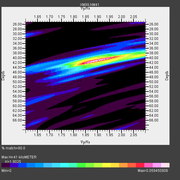
| Thickness Estimate: | 41 km |
| Thickness StdDev: | 1.3 km |
| Vp/Vs Estimate: | 1.90 |
| Vp/Vs StdDev: | 0.05 |
| Vs Estimate: | 3.404 km/s |
| Poisson's Ratio: | 0.31 |
| Peak Value: | 0.06 |
| Assumed Vp: | 6.476 km/s |
| Ps Weight: | 0.33333334 |
| PpPs Weight: | 0.33333334 |
| PsPs Weight: | 0.33333328 |
| Residual Complexity: | 0.490 |
| Nearby stations H: | +- |
| (2.0 deg) Vp/Vs: | +- |
2 with match > 90% ( 28.571428 %) and 7 with match > 80% ( 100.0 %) out of 7.
Download stack as xyz text file.
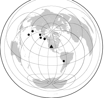
Azimuth Distribution of Events:
Prior Results for this Station
| Study | Thickness | Vp/Vs | Vp | Vs | Poissons Ratio | Extra |
| EARS | 41 km | 1.90 | 6.476 km/s | 3.404 km/s | 0.31 | |
| Crust2.0 | 42 km | 1.76 | 6.476 km/s | 3.675 km/s | 0.26 | Q6,orogen/41.5km no ice, cordilleras, 1.5 km seds. |
| Wilson | 47 km | 1.75 | 6.24 km/s | 3.566 km/s | 0.26 | |
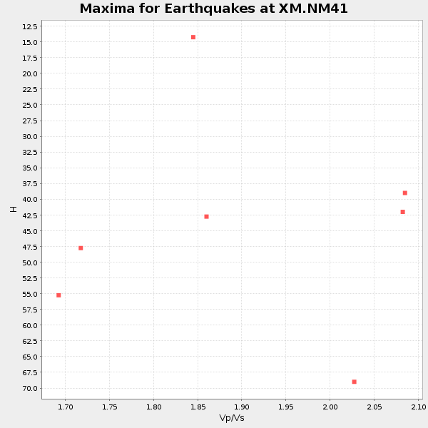
| Global Maxima | 41 km | 1.90 | 6.476 km/s | 3.404 km/s | 0.31 | amp=0.059450906 |
| Local Maxima 1 | 42 km | 1.95 | 6.476 km/s | 3.33 km/s | 0.32 | amp=0.026098209 |
| Local Maxima 2 | 40 km | 1.85 | 6.476 km/s | 3.496 km/s | 0.29 | amp=0.024795555 |
| Local Maxima 3 | 38 km | 2.10 | 6.476 km/s | 3.087 km/s | 0.35 | amp=0.019384174 |
| Local Maxima 4 | 30 km | 1.60 | 6.476 km/s | 4.047 km/s | 0.18 | amp=0.009353164 |
| Predicted Arrivals for vertical incidence (zero ray parameter) | |
| Ps | 5.71 SECOND |
| PpPs | 18.38 SECOND |
| PsPs/PpSs | 24.09 SECOND |
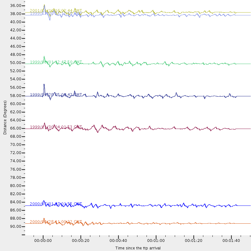
Events Processed for this Station
Download zip of receiver functions as SAC
Plot maxima for each earthquake.
Events Used in the Stack
(7 events)| Radial Match | Distance | Baz | FERegion | Time | Lat/Lon | Depth | Magnitude |
| 95.26326 | 90.4 deg | 298.11 deg | Volcano Islands, Japan Region | 2000/03/28 11:00:22 GMT | (22.3, 143.7) | 126 km | 6.8 MB, 7.6 MS, 7.6 MW, 7.6 MW |
| 95.21872 | 37.1 deg | 319.867 deg | Kodiak Island Region, Alaska | 1999/12/06 23:12:33 GMT | (57.4, -154.5) | 66 km | 6.8 MB, 7.0 MW, 7.0 ML |
| 88.64722 | 66.1 deg | 138.926 deg | Northern Chile | 1999/11/30 04:01:53 GMT | (-18.9, -69.2) | 128 km | 6.2 MB, 6.6 MW, 6.5 MW |
| 88.14728 | 57.8 deg | 316.947 deg | Komandorskiye Ostrova Region | 1999/09/28 05:00:42 GMT | (54.6, 168.3) | 33 km | 5.4 MB, 6.1 MS, 6.1 MW, 6.1 MW |
| 86.18062 | 36.3 deg | 319.637 deg | Kodiak Island Region, Alaska | 2001/01/10 16:02:44 GMT | (57.1, -153.2) | 33 km | 6.2 MB, 6.8 MS, 7.1 MW, 6.8 ML |
| 84.586105 | 85.8 deg | 309.762 deg | Near S. Coast Of Honshu, Japan | 2000/07/01 07:01:55 GMT | (34.2, 139.1) | 10 km | 6.0 MB, 6.1 MS, 6.2 MW, 6.2 MW |
| 81.89034 | 49.5 deg | 310.516 deg | Andreanof Islands, Aleutian Is. | 1999/08/01 12:47:50 GMT | (51.5, -176.3) | 33 km | 5.5 MB, 5.5 MS, 5.8 MW, 5.8 MW |
Losers
(0 events)| Radial Match | Distance | Baz | FERegion | Time | Lat/Lon | Depth | Magnitude | Reason |
