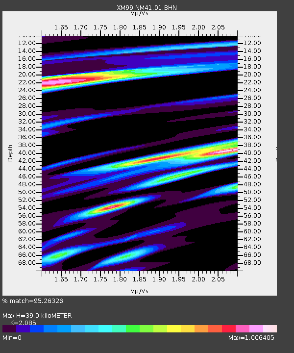
NM41 NewMexico41 - Earthquake Result Viewer
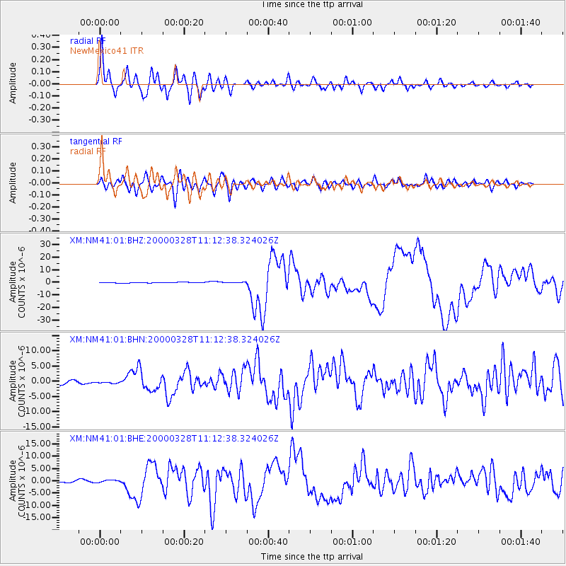
Earthquake location: Volcano Islands, Japan Region
Earthquake latitude/longitude: 22.3/143.7
Earthquake time(UTC): 2000/03/28 (088) 11:00:22 GMT
Earthquake Depth: 126 km
Earthquake Magnitude: 6.8 MB, 7.6 MS, 7.6 MW, 7.6 MW
Earthquake Catalog/Contributor: WHDF/NEIC
Network: XM Rio Grande Seismic Transect
Station: NM41 NewMexico41
Lat/Lon: 36.04 N/108.57 W
Elevation: 1718 m
Distance: 90.4 deg
Az: 50.55 deg
Baz: 298.11 deg
Ray Param: 0.04165095
Estimated Moho Depth: 39.0 km
Estimated Crust Vp/Vs: 2.09
Assumed Crust Vp: 6.476 km/s
Estimated Crust Vs: 3.106 km/s
Estimated Crust Poisson's Ratio: 0.35
Radial Match: 95.26326 %
Radial Bump: 400
Transverse Match: 84.8627 %
Transverse Bump: 400
SOD ConfigId: 27569
Insert Time: 2010-02-26 17:36:13.434 +0000
GWidth: 2.5
Max Bumps: 400
Tol: 0.001

Signal To Noise

ChannelStoNSTALTA
XM:NM41:01:BHN:20000328T11:12:38.324026Z0.50694872.5056423E-74.9425955E-7
XM:NM41:01:BHE:20000328T11:12:38.324026Z0.977787144.559986E-74.663577E-7
XM:NM41:01:BHZ:20000328T11:12:38.324026Z0.949342852.897035E-73.0516216E-7
Arrivals
Ps6.7 SECOND
PpPs18 SECOND
PsPs/PpSs25 SECOND