You are here: Home > Network List > XM99 - Rio Grande Seismic Transect Stations List
> Station NM41 NewMexico41 > Earthquake Result Viewer
NM41 NewMexico41 - Earthquake Result Viewer
| Earthquake location: |
Kodiak Island Region, Alaska |
| Earthquake latitude/longitude: |
57.4/-154.5 |
| Earthquake time(UTC): |
1999/12/06 (340) 23:12:33 GMT |
| Earthquake Depth: |
66 km |
| Earthquake Magnitude: |
6.8 MB, 7.0 MW, 7.0 ML |
| Earthquake Catalog/Contributor: |
WHDF/NEIC |
|
| Network: |
XM Rio Grande Seismic Transect |
| Station: |
NM41 NewMexico41 |
| Lat/Lon: |
36.04 N/108.57 W |
| Elevation: |
1718 m |
|
| Distance: |
37.1 deg |
| Az: |
105.111 deg |
| Baz: |
319.867 deg |
| Ray Param: |
0.07613768 |
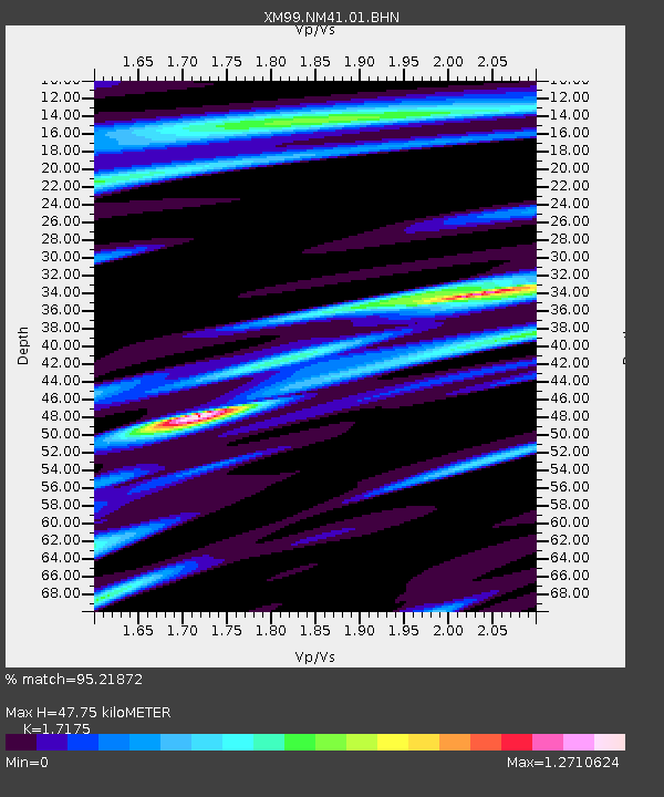
| Estimated Moho Depth: |
47.75 km |
| Estimated Crust Vp/Vs: |
1.72 |
| Assumed Crust Vp: |
6.476 km/s |
| Estimated Crust Vs: |
3.771 km/s |
| Estimated Crust Poisson's Ratio: |
0.24 |
|
| Radial Match: |
95.21872 % |
| Radial Bump: |
333 |
| Transverse Match: |
81.908134 % |
| Transverse Bump: |
400 |
| SOD ConfigId: |
27569 |
| Insert Time: |
2010-02-26 17:36:21.126 +0000 |
| GWidth: |
2.5 |
| Max Bumps: |
400 |
| Tol: |
0.001 |
|
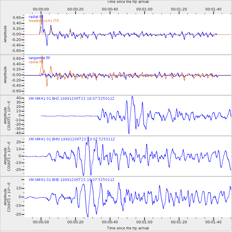
Signal To Noise
| Channel | StoN | STA | LTA |
| XM:NM41:01:BHN:19991206T23:19:07.525011Z | 6.351517 | 1.5224077E-6 | 2.3969199E-7 |
| XM:NM41:01:BHE:19991206T23:19:07.525011Z | 2.7505643 | 1.324448E-6 | 4.815186E-7 |
| XM:NM41:01:BHZ:19991206T23:19:07.525011Z | 14.222487 | 3.5813205E-6 | 2.5180688E-7 |
| Arrivals |
| Ps | 5.7 SECOND |
| PpPs | 19 SECOND |
| PsPs/PpSs | 24 SECOND |


