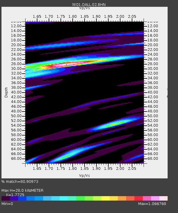
DALL Dalnaspidal - Earthquake Result Viewer

Earthquake location: Near East Coast Of Kamchatka
Earthquake latitude/longitude: 56.3/163.8
Earthquake time(UTC): 2001/08/02 (214) 23:41:06 GMT
Earthquake Depth: 14 km
Earthquake Magnitude: 5.9 MB, 6.2 MS, 6.3 MW, 6.2 ME
Earthquake Catalog/Contributor: WHDF/NEIC
Network: XK Reflections under the Scottish Highlands
Station: DALL Dalnaspidal
Lat/Lon: 56.83 N/4.22 W
Elevation: 515 m
Distance: 66.8 deg
Az: 352.866 deg
Baz: 7.243 deg
Ray Param: 0.05733702
Estimated Moho Depth: 28.0 km
Estimated Crust Vp/Vs: 1.77
Assumed Crust Vp: 6.276 km/s
Estimated Crust Vs: 3.541 km/s
Estimated Crust Poisson's Ratio: 0.27
Radial Match: 80.90973 %
Radial Bump: 400
Transverse Match: 46.76304 %
Transverse Bump: 400
SOD ConfigId: 16820
Insert Time: 2010-03-09 22:59:54.288 +0000
GWidth: 2.5
Max Bumps: 400
Tol: 0.001

Signal To Noise

ChannelStoNSTALTA
XK:DALL:02:BHN:20010802T23:51:26.263018Z2.20623975.7349257E-72.5994117E-7
XK:DALL:02:BHE:20010802T23:51:26.263018Z1.52523223.7584326E-72.4641707E-7
XK:DALL:02:BHZ:20010802T23:51:26.263018Z3.1203067.646732E-72.4506352E-7
Arrivals
Ps3.6 SECOND
PpPs12 SECOND
PsPs/PpSs15 SECOND