
Station XK DALL - Dalnaspidal
Network: XK01 - Reflections under the Scottish Highlands
Nearby stations (2 deg radius)
| Station | Name | (Lat, Lon) | Start / End | Elevation |
| DALL | Dalnaspidal | (56.83, -4.22) | 2001-07-22 / 2003-12-31 | 0.5 km |
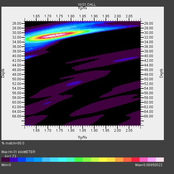
| Crust2 Type: | M5,extended crust, 0.5 km seds. |
| Thickness Estimate: | 31 km |
| Thickness StdDev: | 0.2 km |
| Vp/Vs Estimate: | 1.73 |
| Vp/Vs StdDev: | 0.02 |
| Vs Estimate: | 3.628 km/s |
| Poisson's Ratio: | 0.25 |
| Peak Value: | 0.07 |
| Assumed Vp: | 6.276 km/s |
| Ps Weight: | 0.33333334 |
| PpPs Weight: | 0.33333334 |
| PsPs Weight: | 0.33333328 |
| Residual Complexity: | 0.269 |
| Nearby stations H: | +- |
| (2.0 deg) Vp/Vs: | +- |
2 with match > 90% ( 18.181818 %) and 11 with match > 80% ( 100.0 %) out of 11.
Download stack as xyz text file.
Azimuth Distribution of Events:

Prior Results for this Station
| Study | Thickness | Vp/Vs | Vp | Vs | Poissons Ratio | Extra |
| EARS | 31 km | 1.73 | 6.276 km/s | 3.628 km/s | 0.25 | |
| Crust2.0 | 31 km | 1.78 | 6.276 km/s | 3.529 km/s | 0.27 | M5,extended crust, 0.5 km seds. |
| Global Maxima | 31 km | 1.73 | 6.276 km/s | 3.628 km/s | 0.25 | amp=0.06950022 |
| Local Maxima 1 | 30 km | 1.70 | 6.276 km/s | 3.686 km/s | 0.24 | amp=0.020551002 |
| Local Maxima 2 | 32 km | 1.74 | 6.276 km/s | 3.617 km/s | 0.25 | amp=0.015866976 |
| Local Maxima 3 | 29 km | 1.70 | 6.276 km/s | 3.697 km/s | 0.23 | amp=0.0101657715 |
| Local Maxima 4 | 41 km | 1.60 | 6.276 km/s | 3.922 km/s | 0.18 | amp=0.009818825 |
| Predicted Arrivals for vertical incidence (zero ray parameter) | |
| Ps | 3.61 SECOND |
| PpPs | 13.49 SECOND |
| PsPs/PpSs | 17.09 SECOND |
Events Processed for this Station
Download zip of receiver functions as SAC
Plot maxima for each earthquake.
Events Used in the Stack
(11 events)| Radial Match | Distance | Baz | FERegion | Time | Lat/Lon | Depth | Magnitude |
| 94.35314 | 72.2 deg | 358.551 deg | Rat Islands, Aleutian Islands | 2003/03/17 16:36:17 GMT | (51.3, 178.0) | 33 km | 5.9 MB, 6.7 MS, 7.0 MW, 7.0 MW |
| 93.830864 | 52.3 deg | 79.317 deg | Hindu Kush Region, Afghanistan | 2002/03/03 12:08:07 GMT | (36.4, 70.4) | 209 km | 6.3 MB |
| 89.87913 | 83.1 deg | 76.815 deg | Andaman Islands, India Region | 2002/09/13 22:28:29 GMT | (13.0, 93.1) | 21 km | 6.2 MB, 6.7 MS, 6.5 MW, 6.5 MW |
| 89.06257 | 72.9 deg | 32.498 deg | E. Russia-N.E. China Border Reg. | 2002/06/28 17:19:30 GMT | (43.8, 130.7) | 566 km | 6.7 MB, 7.3 MW, 7.3 MW |
| 88.74968 | 52.3 deg | 79.222 deg | Hindu Kush Region, Afghanistan | 2002/03/03 12:08:19 GMT | (36.5, 70.5) | 226 km | 6.6 MB, 7.4 MW, 7.3 MW |
| 87.91183 | 63.2 deg | 64.975 deg | Qinghai, China | 2001/11/14 09:26:10 GMT | (35.9, 90.5) | 10 km | 6.1 MB, 8.0 MS, 7.8 MW, 7.7 MW |
| 87.506096 | 77.2 deg | 264.785 deg | South Of Panama | 2002/07/31 00:16:44 GMT | (7.9, -82.8) | 10 km | 6.0 MB, 6.4 MS, 6.5 MW, 6.4 MW |
| 83.43184 | 78.5 deg | 25.197 deg | Hokkaido, Japan Region | 2001/08/13 20:11:23 GMT | (41.0, 142.3) | 38 km | 6.0 MB, 6.3 MS, 6.4 MW, 6.3 ME |
| 83.1758 | 62.2 deg | 343.476 deg | Southern Alaska | 2001/07/28 07:32:43 GMT | (59.0, -155.1) | 131 km | 5.7 MB, 5.7 MS, 6.6 MW, 6.2 ME |
| 82.919754 | 76.8 deg | 256.69 deg | Colombia | 2001/09/22 03:23:38 GMT | (3.9, -76.0) | 179 km | 6.0 MB, 6.0 MW, 6.0 MW |
| 80.90973 | 66.8 deg | 7.243 deg | Near East Coast Of Kamchatka | 2001/08/02 23:41:06 GMT | (56.3, 163.8) | 14 km | 5.9 MB, 6.2 MS, 6.3 MW, 6.2 ME |
Losers
(0 events)| Radial Match | Distance | Baz | FERegion | Time | Lat/Lon | Depth | Magnitude | Reason |
