You are here: Home > Network List > XK01 - Reflections under the Scottish Highlands Stations List
> Station DALL Dalnaspidal > Earthquake Result Viewer
DALL Dalnaspidal - Earthquake Result Viewer
| Earthquake location: |
E. Russia-N.E. China Border Reg. |
| Earthquake latitude/longitude: |
43.8/130.7 |
| Earthquake time(UTC): |
2002/06/28 (179) 17:19:30 GMT |
| Earthquake Depth: |
566 km |
| Earthquake Magnitude: |
6.7 MB, 7.3 MW, 7.3 MW |
| Earthquake Catalog/Contributor: |
WHDF/NEIC |
|
| Network: |
XK Reflections under the Scottish Highlands |
| Station: |
DALL Dalnaspidal |
| Lat/Lon: |
56.83 N/4.22 W |
| Elevation: |
515 m |
|
| Distance: |
72.9 deg |
| Az: |
335.95 deg |
| Baz: |
32.498 deg |
| Ray Param: |
0.05150994 |
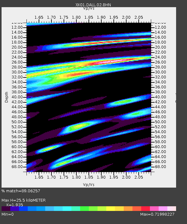
| Estimated Moho Depth: |
25.5 km |
| Estimated Crust Vp/Vs: |
1.93 |
| Assumed Crust Vp: |
6.276 km/s |
| Estimated Crust Vs: |
3.243 km/s |
| Estimated Crust Poisson's Ratio: |
0.32 |
|
| Radial Match: |
89.06257 % |
| Radial Bump: |
400 |
| Transverse Match: |
87.83206 % |
| Transverse Bump: |
400 |
| SOD ConfigId: |
16820 |
| Insert Time: |
2010-03-09 23:00:00.962 +0000 |
| GWidth: |
2.5 |
| Max Bumps: |
400 |
| Tol: |
0.001 |
|

Signal To Noise
| Channel | StoN | STA | LTA |
| XK:DALL:02:BHN:20020628T17:29:31.223003Z | 5.9111924 | 1.2987598E-6 | 2.1971198E-7 |
| XK:DALL:02:BHE:20020628T17:29:31.223003Z | 2.8128226 | 1.0846162E-6 | 3.8559708E-7 |
| XK:DALL:02:BHZ:20020628T17:29:31.223003Z | 10.925127 | 3.950042E-6 | 3.615557E-7 |
| Arrivals |
| Ps | 3.9 SECOND |
| PpPs | 12 SECOND |
| PsPs/PpSs | 16 SECOND |


