You are here: Home > Network List > XK01 - Reflections under the Scottish Highlands Stations List
> Station DUND Dundonnell > Earthquake Result Viewer
DUND Dundonnell - Earthquake Result Viewer
| Earthquake location: |
Hindu Kush Region, Afghanistan |
| Earthquake latitude/longitude: |
36.4/70.4 |
| Earthquake time(UTC): |
2002/03/03 (062) 12:08:07 GMT |
| Earthquake Depth: |
209 km |
| Earthquake Magnitude: |
6.3 MB |
| Earthquake Catalog/Contributor: |
WHDF/NEIC |
|
| Network: |
XK Reflections under the Scottish Highlands |
| Station: |
DUND Dundonnell |
| Lat/Lon: |
57.87 N/5.26 W |
| Elevation: |
115 m |
|
| Distance: |
52.7 deg |
| Az: |
319.379 deg |
| Baz: |
79.308 deg |
| Ray Param: |
0.065841585 |
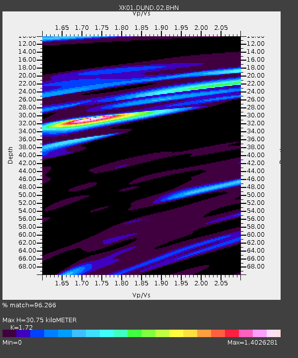
| Estimated Moho Depth: |
30.75 km |
| Estimated Crust Vp/Vs: |
1.72 |
| Assumed Crust Vp: |
6.276 km/s |
| Estimated Crust Vs: |
3.649 km/s |
| Estimated Crust Poisson's Ratio: |
0.24 |
|
| Radial Match: |
96.266 % |
| Radial Bump: |
325 |
| Transverse Match: |
80.72943 % |
| Transverse Bump: |
400 |
| SOD ConfigId: |
16820 |
| Insert Time: |
2010-03-09 23:00:23.759 +0000 |
| GWidth: |
2.5 |
| Max Bumps: |
400 |
| Tol: |
0.001 |
|

Signal To Noise
| Channel | StoN | STA | LTA |
| XK:DUND:02:BHN:20020303T12:16:29.988009Z | 0.80504304 | 1.1219346E-6 | 1.3936329E-6 |
| XK:DUND:02:BHE:20020303T12:16:29.988009Z | 1.7209991 | 1.784466E-6 | 1.036878E-6 |
| XK:DUND:02:BHZ:20020303T12:16:29.988009Z | 1.7346256 | 2.9218334E-6 | 1.6844172E-6 |
| Arrivals |
| Ps | 3.7 SECOND |
| PpPs | 13 SECOND |
| PsPs/PpSs | 16 SECOND |


