
Station XK DUND - Dundonnell
Network: XK01 - Reflections under the Scottish Highlands
Nearby stations (2 deg radius)
| Station | Name | (Lat, Lon) | Start / End | Elevation |
| DUND | Dundonnell | (57.87, -5.26) | 2001-07-07 / 2003-12-31 | 0.1 km |
| Crust2 Type: | M5,extended crust, 0.5 km seds. |
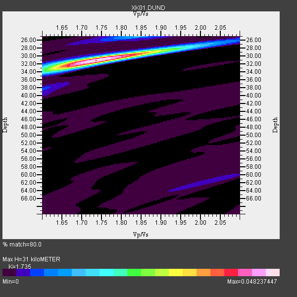
| Thickness Estimate: | 31 km |
| Thickness StdDev: | 0.4 km |
| Vp/Vs Estimate: | 1.74 |
| Vp/Vs StdDev: | 0.02 |
| Vs Estimate: | 3.617 km/s |
| Poisson's Ratio: | 0.25 |
| Peak Value: | 0.05 |
| Assumed Vp: | 6.276 km/s |
| Ps Weight: | 0.33333334 |
| PpPs Weight: | 0.33333334 |
| PsPs Weight: | 0.33333328 |
| Residual Complexity: | 0.248 |
| Nearby stations H: | +- |
| (2.0 deg) Vp/Vs: | +- |
7 with match > 90% ( 70.0 %) and 10 with match > 80% ( 100.0 %) out of 10.
Download stack as xyz text file.
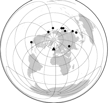
Azimuth Distribution of Events:
Prior Results for this Station
| Study | Thickness | Vp/Vs | Vp | Vs | Poissons Ratio | Extra |
| EARS | 31 km | 1.74 | 6.276 km/s | 3.617 km/s | 0.25 | |
| Crust2.0 | 31 km | 1.78 | 6.276 km/s | 3.529 km/s | 0.27 | M5,extended crust, 0.5 km seds. |
| Global Maxima | 31 km | 1.74 | 6.276 km/s | 3.617 km/s | 0.25 | amp=0.048237447 |
| Local Maxima 1 | 28 km | 1.90 | 6.276 km/s | 3.303 km/s | 0.31 | amp=0.013610537 |
| Local Maxima 2 | 25 km | 1.84 | 6.276 km/s | 3.411 km/s | 0.29 | amp=0.011333142 |
| Local Maxima 3 | 33 km | 1.64 | 6.276 km/s | 3.821 km/s | 0.21 | amp=0.00952891 |
| Local Maxima 4 | 62 km | 2.01 | 6.276 km/s | 3.122 km/s | 0.34 | amp=0.0043644 |
| Predicted Arrivals for vertical incidence (zero ray parameter) | |
| Ps | 3.63 SECOND |
| PpPs | 13.51 SECOND |
| PsPs/PpSs | 17.14 SECOND |
Events Processed for this Station
Download zip of receiver functions as SAC
Plot maxima for each earthquake.
Events Used in the Stack
(10 events)| Radial Match | Distance | Baz | FERegion | Time | Lat/Lon | Depth | Magnitude |
| 99.49372 | 77.6 deg | 24.526 deg | Hokkaido, Japan Region | 2002/10/14 14:12:43 GMT | (41.2, 142.2) | 61 km | 5.9 MB, 6.1 MW, 6.1 MW |
| 96.266 | 52.7 deg | 79.308 deg | Hindu Kush Region, Afghanistan | 2002/03/03 12:08:07 GMT | (36.4, 70.4) | 209 km | 6.3 MB |
| 93.90667 | 52.7 deg | 79.214 deg | Hindu Kush Region, Afghanistan | 2002/03/03 12:08:19 GMT | (36.5, 70.5) | 226 km | 6.6 MB, 7.4 MW, 7.3 MW |
| 92.513794 | 78.9 deg | 287.433 deg | Near Coast Of Jalisco, Mexico | 2003/01/22 02:06:34 GMT | (18.8, -104.1) | 24 km | 6.5 MB, 7.6 MS, 7.6 MW, 7.4 MW |
| 92.09149 | 93.9 deg | 53.596 deg | Philippine Islands Region | 2002/10/12 23:43:12 GMT | (15.1, 118.5) | 33 km | 5.6 MB, 5.6 MS, 6.1 MW |
| 92.0754 | 71.2 deg | 357.85 deg | Rat Islands, Aleutian Islands | 2003/03/17 16:36:17 GMT | (51.3, 178.0) | 33 km | 5.9 MB, 6.7 MS, 7.0 MW, 7.0 MW |
| 91.11312 | 75.4 deg | 20.421 deg | Kuril Islands | 2002/05/21 20:04:16 GMT | (44.4, 146.6) | 150 km | 5.5 MB, 5.5 MW, 5.5 MW |
| 88.18129 | 87.7 deg | 46.183 deg | Taiwan Region | 2001/12/18 04:02:58 GMT | (24.0, 122.7) | 14 km | 6.3 MB, 7.3 MS, 6.9 MW, 6.8 MW |
| 85.656166 | 61.0 deg | 342.727 deg | Southern Alaska | 2001/07/28 07:32:43 GMT | (59.0, -155.1) | 131 km | 5.7 MB, 5.7 MS, 6.6 MW, 6.2 ME |
| 83.39652 | 72.3 deg | 31.946 deg | E. Russia-N.E. China Border Reg. | 2002/06/28 17:19:30 GMT | (43.8, 130.7) | 566 km | 6.7 MB, 7.3 MW, 7.3 MW |
Losers
(0 events)| Radial Match | Distance | Baz | FERegion | Time | Lat/Lon | Depth | Magnitude | Reason |
