You are here: Home > Network List > XK01 - Reflections under the Scottish Highlands Stations List
> Station GARY Harvest Marine Loch Gary Facility > Earthquake Result Viewer
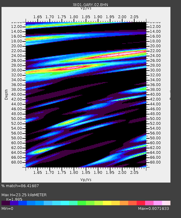
GARY Harvest Marine Loch Gary Facility - Earthquake Result Viewer
| Earthquake location: |
E. Russia-N.E. China Border Reg. |
| Earthquake latitude/longitude: |
43.8/130.7 |
| Earthquake time(UTC): |
2002/06/28 (179) 17:19:30 GMT |
| Earthquake Depth: |
566 km |
| Earthquake Magnitude: |
6.7 MB, 7.3 MW, 7.3 MW |
| Earthquake Catalog/Contributor: |
WHDF/NEIC |
|
| Network: |
XK Reflections under the Scottish Highlands |
| Station: |
GARY Harvest Marine Loch Gary Facility |
| Lat/Lon: |
57.08 N/4.96 W |
| Elevation: |
153 m |
|
| Distance: |
72.9 deg |
| Az: |
336.448 deg |
| Baz: |
32.022 deg |
| Ray Param: |
0.05150332 |
| Estimated Moho Depth: |
23.25 km |
| Estimated Crust Vp/Vs: |
1.99 |
| Assumed Crust Vp: |
6.276 km/s |
| Estimated Crust Vs: |
3.162 km/s |
| Estimated Crust Poisson's Ratio: |
0.33 |
|
| Radial Match: |
86.41687 % |
| Radial Bump: |
400 |
| Transverse Match: |
78.17374 % |
| Transverse Bump: |
400 |
| SOD ConfigId: |
16820 |
| Insert Time: |
2010-03-09 23:00:40.585 +0000 |
| GWidth: |
2.5 |
| Max Bumps: |
400 |
| Tol: |
0.001 |
|

Signal To Noise
| Channel | StoN | STA | LTA |
| XK:GARY:02:BHN:20020628T17:29:31.251018Z | 3.7908337 | 1.0433073E-6 | 2.752184E-7 |
| XK:GARY:02:BHE:20020628T17:29:31.251018Z | 3.2903156 | 1.0539974E-6 | 3.203332E-7 |
| XK:GARY:02:BHZ:20020628T17:29:31.251018Z | 6.202069 | 2.7564117E-6 | 4.4443425E-7 |
| Arrivals |
| Ps | 3.7 SECOND |
| PpPs | 11 SECOND |
| PsPs/PpSs | 15 SECOND |


