
Station XK GARY - Harvest Marine Loch Gary Facility
Network: XK01 - Reflections under the Scottish Highlands
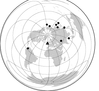
Nearby stations (2 deg radius)
| Station | Name | (Lat, Lon) | Start / End | Elevation |
| GARY | Harvest Marine Loch Gary Facility | (57.08, -4.96) | 2001-07-17 / 2003-12-31 | 0.2 km |
| Crust2 Type: | M5,extended crust, 0.5 km seds. |
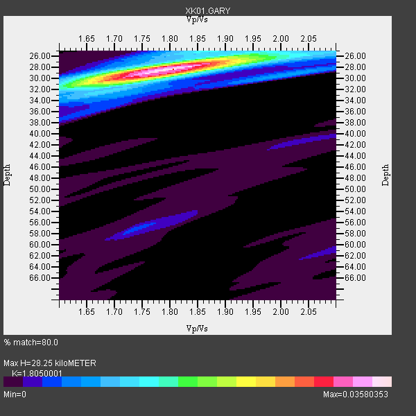
| Thickness Estimate: | 28 km |
| Thickness StdDev: | 0.7 km |
| Vp/Vs Estimate: | 1.81 |
| Vp/Vs StdDev: | 0.03 |
| Vs Estimate: | 3.477 km/s |
| Poisson's Ratio: | 0.28 |
| Peak Value: | 0.04 |
| Assumed Vp: | 6.276 km/s |
| Ps Weight: | 0.33333334 |
| PpPs Weight: | 0.33333334 |
| PsPs Weight: | 0.33333328 |
| Residual Complexity: | 0.371 |
| Nearby stations H: | +- |
| (2.0 deg) Vp/Vs: | +- |
4 with match > 90% ( 36.363636 %) and 11 with match > 80% ( 100.0 %) out of 11.
Download stack as xyz text file.
Azimuth Distribution of Events:
Prior Results for this Station
| Study | Thickness | Vp/Vs | Vp | Vs | Poissons Ratio | Extra |
| EARS | 28 km | 1.81 | 6.276 km/s | 3.477 km/s | 0.28 | |
| Crust2.0 | 31 km | 1.78 | 6.276 km/s | 3.529 km/s | 0.27 | M5,extended crust, 0.5 km seds. |
| Global Maxima | 28 km | 1.81 | 6.276 km/s | 3.477 km/s | 0.28 | amp=0.03580353 |
| Local Maxima 1 | 26 km | 1.91 | 6.276 km/s | 3.29 km/s | 0.31 | amp=0.01240733 |
| Local Maxima 2 | 31 km | 1.66 | 6.276 km/s | 3.775 km/s | 0.22 | amp=0.011000982 |
| Local Maxima 3 | 29 km | 2.03 | 6.276 km/s | 3.095 km/s | 0.34 | amp=0.008109813 |
| Local Maxima 4 | 25 km | 1.81 | 6.276 km/s | 3.463 km/s | 0.28 | amp=0.0049909484 |
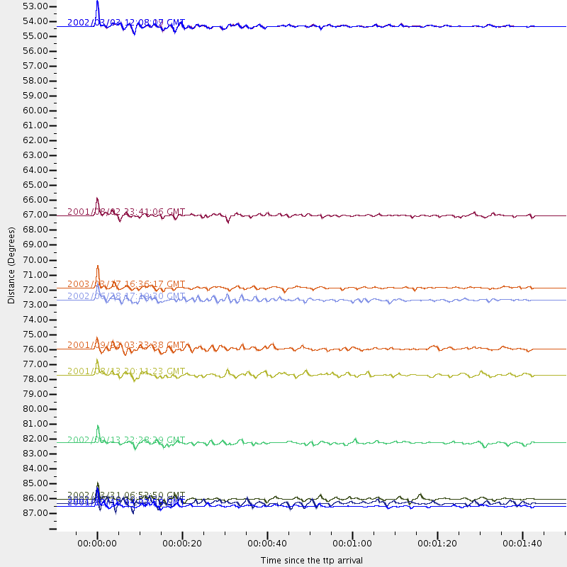
| Predicted Arrivals for vertical incidence (zero ray parameter) | |
| Ps | 3.62 SECOND |
| PpPs | 12.63 SECOND |
| PsPs/PpSs | 16.25 SECOND |
Events Processed for this Station
Download zip of receiver functions as SAC
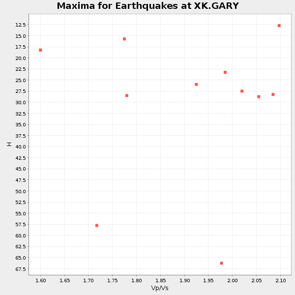
Plot maxima for each earthquake.
Events Used in the Stack
(11 events)| Radial Match | Distance | Baz | FERegion | Time | Lat/Lon | Depth | Magnitude |
| 94.16096 | 72.0 deg | 358.057 deg | Rat Islands, Aleutian Islands | 2003/03/17 16:36:17 GMT | (51.3, 178.0) | 33 km | 5.9 MB, 6.7 MS, 7.0 MW, 7.0 MW |
| 92.96663 | 52.7 deg | 78.938 deg | Hindu Kush Region, Afghanistan | 2002/03/03 12:08:07 GMT | (36.4, 70.4) | 209 km | 6.3 MB |
| 92.45703 | 52.6 deg | 78.843 deg | Hindu Kush Region, Afghanistan | 2002/03/03 12:08:19 GMT | (36.5, 70.5) | 226 km | 6.6 MB, 7.4 MW, 7.3 MW |
| 91.508286 | 88.1 deg | 46.409 deg | Taiwan Region | 2001/12/18 04:02:58 GMT | (24.0, 122.7) | 14 km | 6.3 MB, 7.3 MS, 6.9 MW, 6.8 MW |
| 87.10397 | 87.6 deg | 46.726 deg | Taiwan Region | 2002/03/31 06:52:50 GMT | (24.3, 122.2) | 33 km | 6.4 MB, 7.4 MS, 7.1 MW, 7.1 MW |
| 86.41687 | 72.9 deg | 32.022 deg | E. Russia-N.E. China Border Reg. | 2002/06/28 17:19:30 GMT | (43.8, 130.7) | 566 km | 6.7 MB, 7.3 MW, 7.3 MW |
| 85.08663 | 66.7 deg | 6.807 deg | Near East Coast Of Kamchatka | 2001/08/02 23:41:06 GMT | (56.3, 163.8) | 14 km | 5.9 MB, 6.2 MS, 6.3 MW, 6.2 ME |
| 83.85406 | 76.5 deg | 255.988 deg | Colombia | 2001/09/22 03:23:38 GMT | (3.9, -76.0) | 179 km | 6.0 MB, 6.0 MW, 6.0 MW |
| 82.15903 | 83.5 deg | 76.231 deg | Andaman Islands, India Region | 2002/09/13 22:28:29 GMT | (13.0, 93.1) | 21 km | 6.2 MB, 6.7 MS, 6.5 MW, 6.5 MW |
| 81.230545 | 87.9 deg | 27.965 deg | Southeast Of Honshu, Japan | 2002/08/20 10:59:32 GMT | (31.0, 142.0) | 9.0 km | 5.4 MB, 6.2 MS, 6.3 MW, 6.1 MW |
| 80.68545 | 78.4 deg | 24.671 deg | Hokkaido, Japan Region | 2001/08/13 20:11:23 GMT | (41.0, 142.3) | 38 km | 6.0 MB, 6.3 MS, 6.4 MW, 6.3 ME |
Losers
(0 events)| Radial Match | Distance | Baz | FERegion | Time | Lat/Lon | Depth | Magnitude | Reason |
