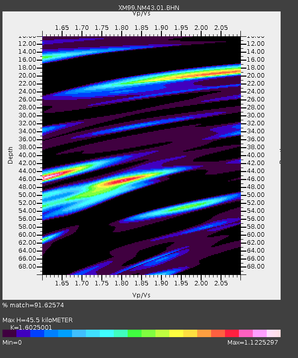
NM43 NewMexico43 - Earthquake Result Viewer
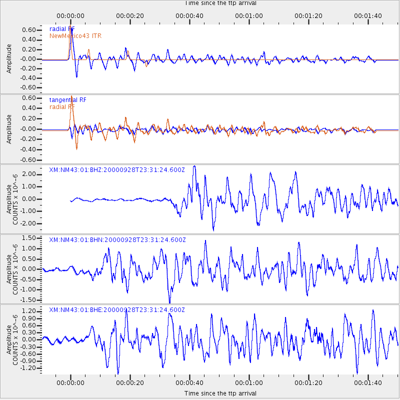
Earthquake location: Near Coast Of Ecuador
Earthquake latitude/longitude: -0.2/-80.6
Earthquake time(UTC): 2000/09/28 (272) 23:23:43 GMT
Earthquake Depth: 23 km
Earthquake Magnitude: 5.8 MB, 6.0 MS, 6.6 MW, 6.4 MW
Earthquake Catalog/Contributor: WHDF/NEIC
Network: XM Rio Grande Seismic Transect
Station: NM43 NewMexico43
Lat/Lon: 36.25 N/108.89 W
Elevation: 1991 m
Distance: 44.8 deg
Az: 327.051 deg
Baz: 137.713 deg
Ray Param: 0.071655706
Estimated Moho Depth: 45.5 km
Estimated Crust Vp/Vs: 1.60
Assumed Crust Vp: 6.476 km/s
Estimated Crust Vs: 4.041 km/s
Estimated Crust Poisson's Ratio: 0.18
Radial Match: 91.62574 %
Radial Bump: 400
Transverse Match: 78.41391 %
Transverse Bump: 400
SOD ConfigId: 27569
Insert Time: 2010-02-26 17:36:44.183 +0000
GWidth: 2.5
Max Bumps: 400
Tol: 0.001

Signal To Noise

ChannelStoNSTALTA
XM:NM43:01:BHN:20000928T23:31:24.600Z1.64776651.4000048E-78.496379E-8
XM:NM43:01:BHE:20000928T23:31:24.600Z0.485650665.389319E-81.109711E-7
XM:NM43:01:BHZ:20000928T23:31:24.600Z1.99918721.4672959E-77.3394624E-8
Arrivals
Ps4.6 SECOND
PpPs17 SECOND
PsPs/PpSs22 SECOND