
Station XM NM43 - NewMexico43
Network: XM99 - Rio Grande Seismic Transect
Nearby stations (2 deg radius)
| Station | Name | (Lat, Lon) | Start / End | Elevation |
| NM43 | NewMexico43 | (36.25, -108.89) | 1999-11-15 / 2001-12-31 | 1991 m |
| Crust2 Type: | Q6,orogen/41.5km no ice, cordilleras, 1.5 km seds. |
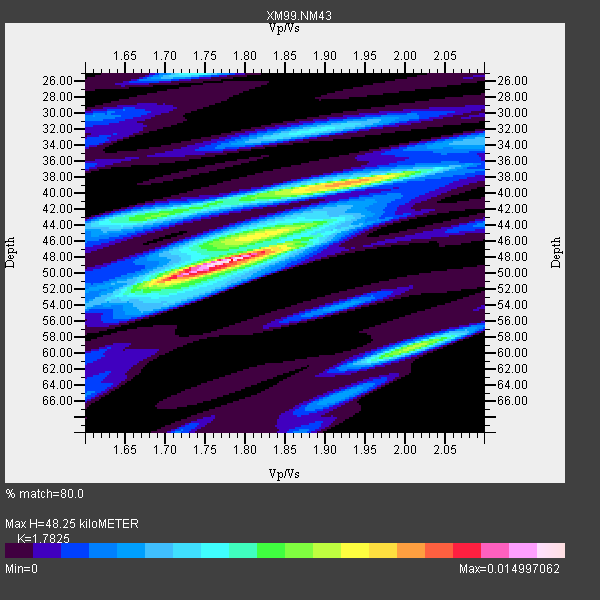
| Thickness Estimate: | 48 km |
| Thickness StdDev: | 5.8 km |
| Vp/Vs Estimate: | 1.78 |
| Vp/Vs StdDev: | 0.09 |
| Vs Estimate: | 3.633 km/s |
| Poisson's Ratio: | 0.27 |
| Peak Value: | 0.01 |
| Assumed Vp: | 6.476 km/s |
| Ps Weight: | 0.33333334 |
| PpPs Weight: | 0.33333334 |
| PsPs Weight: | 0.33333328 |
| Residual Complexity: | 0.716 |
| Nearby stations H: | +- |
| (2.0 deg) Vp/Vs: | +- |
6 with match > 90% ( 46.153847 %) and 12 with match > 80% ( 92.30769 %) out of 13.
Download stack as xyz text file.
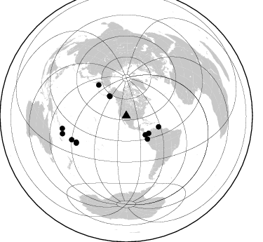
Azimuth Distribution of Events:
Prior Results for this Station
| Study | Thickness | Vp/Vs | Vp | Vs | Poissons Ratio | Extra |
| EARS | 48 km | 1.78 | 6.476 km/s | 3.633 km/s | 0.27 | |
| Crust2.0 | 42 km | 1.76 | 6.476 km/s | 3.675 km/s | 0.26 | Q6,orogen/41.5km no ice, cordilleras, 1.5 km seds. |
| Wilson | 46 km | 1.75 | 6.27 km/s | 3.583 km/s | 0.26 | |
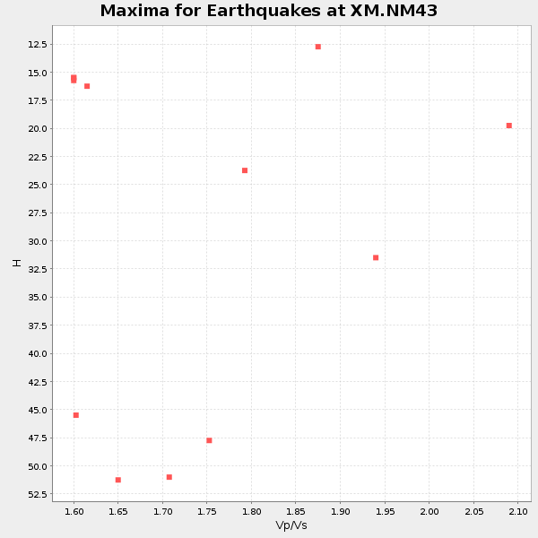
| Global Maxima | 48 km | 1.78 | 6.476 km/s | 3.633 km/s | 0.27 | amp=0.014997062 |
| Local Maxima 1 | 39 km | 1.92 | 6.476 km/s | 3.373 km/s | 0.31 | amp=0.010671151 |
| Local Maxima 2 | 59 km | 2.02 | 6.476 km/s | 3.214 km/s | 0.34 | amp=0.0085927015 |
| Local Maxima 3 | 43 km | 1.68 | 6.476 km/s | 3.855 km/s | 0.23 | amp=0.006843772 |
| Local Maxima 4 | 51 km | 1.70 | 6.476 km/s | 3.821 km/s | 0.23 | amp=0.006306682 |
| Predicted Arrivals for vertical incidence (zero ray parameter) | |
| Ps | 5.83 SECOND |
| PpPs | 20.73 SECOND |
| PsPs/PpSs | 26.56 SECOND |
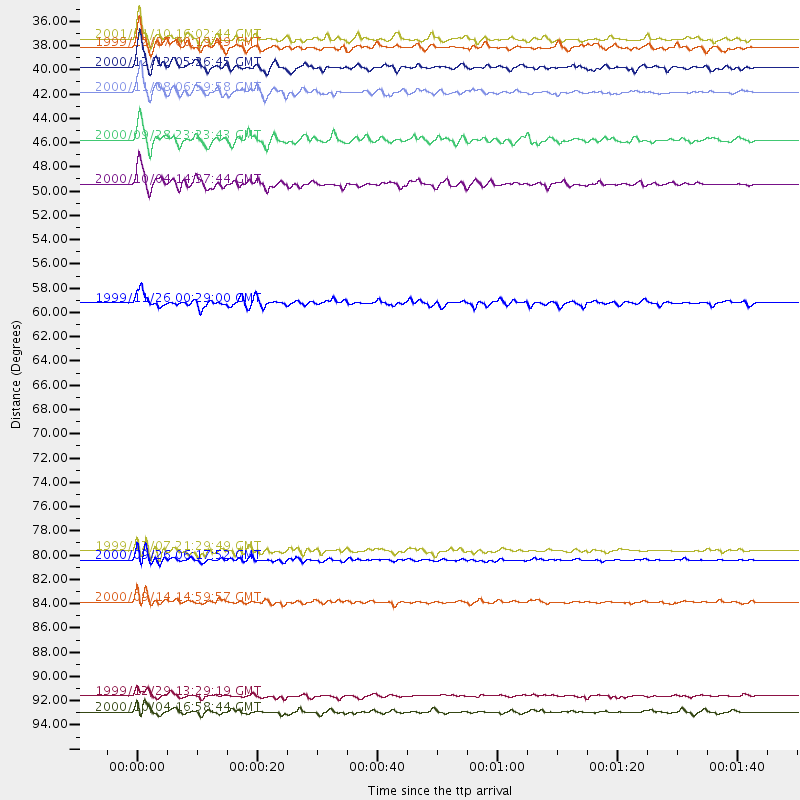
Events Processed for this Station
Download zip of receiver functions as SAC
Plot maxima for each earthquake.
Events Used in the Stack
(12 events)| Radial Match | Distance | Baz | FERegion | Time | Lat/Lon | Depth | Magnitude |
| 96.763306 | 48.6 deg | 108.971 deg | Windward Islands | 2000/10/04 14:37:44 GMT | (11.1, -62.6) | 110 km | 5.6 MB, 5.4 MS, 6.1 MW, 5.9 MD |
| 95.49467 | 81.2 deg | 241.286 deg | Tonga Islands | 2000/09/26 06:17:52 GMT | (-17.2, -173.9) | 56 km | 6.1 MB, 6.1 MS, 6.4 MW, 6.1 ME |
| 91.62574 | 44.8 deg | 137.713 deg | Near Coast Of Ecuador | 2000/09/28 23:23:43 GMT | (-0.2, -80.6) | 23 km | 5.8 MB, 6.0 MS, 6.6 MW, 6.4 MW |
| 91.4345 | 36.8 deg | 319.67 deg | Kodiak Island Region, Alaska | 1999/12/07 00:19:49 GMT | (57.4, -154.5) | 41 km | 6.5 MB, 6.1 MS, 6.4 MW, 6.3 ML |
| 91.31959 | 36.0 deg | 319.529 deg | Kodiak Island Region, Alaska | 2001/01/10 16:02:44 GMT | (57.1, -153.2) | 33 km | 6.2 MB, 6.8 MS, 7.1 MW, 6.8 ML |
| 91.08459 | 40.6 deg | 128.142 deg | Panama-Colombia Border Region | 2000/11/08 06:59:58 GMT | (7.0, -77.8) | 17 km | 6.0 MB, 6.4 MS, 6.5 MW, 6.2 ML |
| 88.93279 | 38.5 deg | 135.127 deg | South Of Panama | 2000/12/12 05:26:45 GMT | (6.0, -82.7) | 10 km | 5.8 MB, 5.7 MS, 6.3 ME, 6.1 MW |
| 88.473206 | 94.4 deg | 254.231 deg | Vanuatu Islands | 2000/10/04 16:58:44 GMT | (-15.4, 166.9) | 23 km | 6.1 MB, 6.9 MS, 6.8 MW, 6.5 ME |
| 88.23753 | 84.8 deg | 246.344 deg | Fiji Islands | 2000/09/14 14:59:57 GMT | (-15.7, 179.8) | 33 km | 5.7 MB, 6.2 MS, 6.3 MW, 6.2 MW |
| 85.9729 | 93.0 deg | 258.794 deg | Santa Cruz Islands | 1999/12/29 13:29:19 GMT | (-10.9, 165.4) | 33 km | 5.6 MB, 6.8 MS, 6.8 MW, 6.3 MW |
| 85.45279 | 58.9 deg | 318.03 deg | Komandorskiye Ostrova Region | 1999/11/26 00:29:00 GMT | (55.1, 165.4) | 33 km | 5.6 MB, 5.8 MS |
| 80.03577 | 80.4 deg | 242.271 deg | Tonga Islands | 1999/12/07 21:29:49 GMT | (-15.9, -174.0) | 138 km | 6.2 MB, 6.4 MW, 6.4 MW |
Losers
(1 events)| Radial Match | Distance | Baz | FERegion | Time | Lat/Lon | Depth | Magnitude | Reason |
| 94.9206 | 95.9 deg | 247.136 deg | Southeast Of Loyalty Islands | 2001/02/28 13:05:31 GMT | (-22.0, 170.1) | 10 km | 5.8 MB, 6.1 MS, 6.2 MW |
