NM43 NewMexico43 - Earthquake Result Viewer
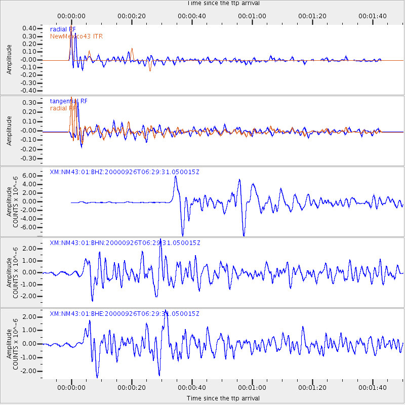
Earthquake location: Tonga Islands
Earthquake latitude/longitude: -17.2/-173.9
Earthquake time(UTC): 2000/09/26 (270) 06:17:52 GMT
Earthquake Depth: 56 km
Earthquake Magnitude: 6.1 MB, 6.1 MS, 6.4 MW, 6.1 ME
Earthquake Catalog/Contributor: WHDF/NEIC
Network: XM Rio Grande Seismic Transect
Station: NM43 NewMexico43
Lat/Lon: 36.25 N/108.89 W
Elevation: 1991 m
Distance: 81.2 deg
Az: 47.868 deg
Baz: 241.286 deg
Ray Param: 0.047660157
Estimated Moho Depth: 15.5 km
Estimated Crust Vp/Vs: 1.60
Assumed Crust Vp: 6.476 km/s
Estimated Crust Vs: 4.047 km/s
Estimated Crust Poisson's Ratio: 0.18
Radial Match: 95.49467 %
Radial Bump: 400
Transverse Match: 91.71007 %
Transverse Bump: 400
SOD ConfigId: 16820
Insert Time: 2010-02-26 17:36:50.820 +0000
GWidth: 2.5
Max Bumps: 400
Tol: 0.001

Signal To Noise

ChannelStoNSTALTA
XM:NM43:01:BHN:20000926T06:29:31.050015Z3.71828824.1426583E-71.1141305E-7
XM:NM43:01:BHE:20000926T06:29:31.050015Z5.86098583.9287602E-76.703241E-8
XM:NM43:01:BHZ:20000926T06:29:31.050015Z25.9701542.0826787E-68.0195086E-8
Arrivals
Ps1.5 SECOND
PpPs6.0 SECOND
PsPs/PpSs7.5 SECOND