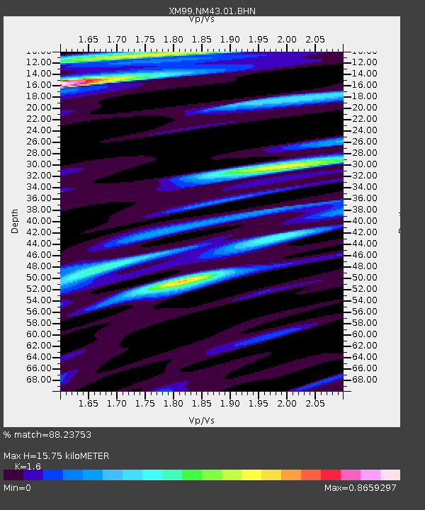
NM43 NewMexico43 - Earthquake Result Viewer
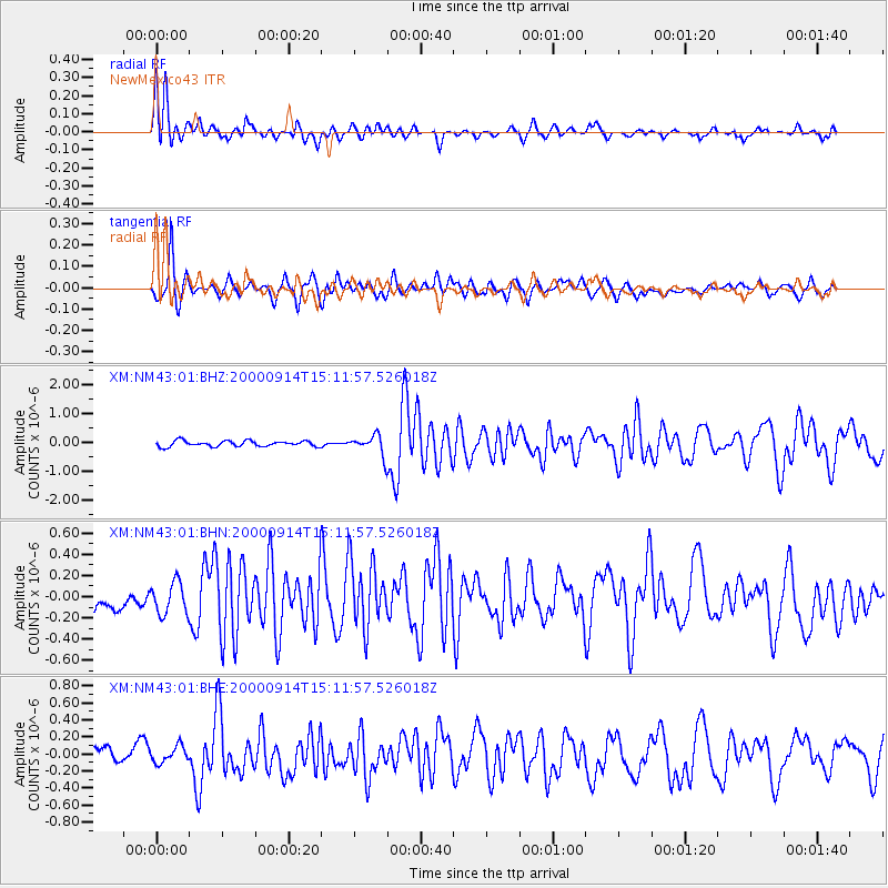
Earthquake location: Fiji Islands
Earthquake latitude/longitude: -15.7/179.8
Earthquake time(UTC): 2000/09/14 (258) 14:59:57 GMT
Earthquake Depth: 33 km
Earthquake Magnitude: 5.7 MB, 6.2 MS, 6.3 MW, 6.2 MW
Earthquake Catalog/Contributor: WHDF/NEIC
Network: XM Rio Grande Seismic Transect
Station: NM43 NewMexico43
Lat/Lon: 36.25 N/108.89 W
Elevation: 1991 m
Distance: 84.8 deg
Az: 50.254 deg
Baz: 246.344 deg
Ray Param: 0.045181207
Estimated Moho Depth: 15.75 km
Estimated Crust Vp/Vs: 1.60
Assumed Crust Vp: 6.476 km/s
Estimated Crust Vs: 4.047 km/s
Estimated Crust Poisson's Ratio: 0.18
Radial Match: 88.23753 %
Radial Bump: 400
Transverse Match: 73.050705 %
Transverse Bump: 400
SOD ConfigId: 16820
Insert Time: 2010-02-26 17:36:51.931 +0000
GWidth: 2.5
Max Bumps: 400
Tol: 0.001

Signal To Noise

ChannelStoNSTALTA
XM:NM43:01:BHN:20000914T15:11:57.526018Z1.22352481.5122562E-71.2359833E-7
XM:NM43:01:BHE:20000914T15:11:57.526018Z0.88416139.9890414E-81.1297759E-7
XM:NM43:01:BHZ:20000914T15:11:57.526018Z3.488093.469138E-79.945666E-8
Arrivals
Ps1.5 SECOND
PpPs6.2 SECOND
PsPs/PpSs7.7 SECOND