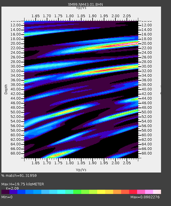
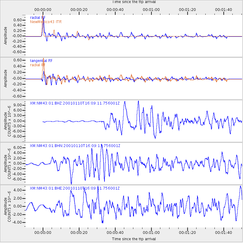
NM43 NewMexico43 - Earthquake Result Viewer

Earthquake location: Kodiak Island Region, Alaska
Earthquake latitude/longitude: 57.1/-153.2
Earthquake time(UTC): 2001/01/10 (010) 16:02:44 GMT
Earthquake Depth: 33 km
Earthquake Magnitude: 6.2 MB, 6.8 MS, 7.1 MW, 6.8 ML
Earthquake Catalog/Contributor: WHDF/NEIC
Network: XM Rio Grande Seismic Transect
Station: NM43 NewMexico43
Lat/Lon: 36.25 N/108.89 W
Elevation: 1991 m
Distance: 36.0 deg
Az: 106.095 deg
Baz: 319.529 deg
Ray Param: 0.07685558
Estimated Moho Depth: 19.75 km
Estimated Crust Vp/Vs: 2.09
Assumed Crust Vp: 6.476 km/s
Estimated Crust Vs: 3.099 km/s
Estimated Crust Poisson's Ratio: 0.35
Radial Match: 91.31959 %
Radial Bump: 364
Transverse Match: 85.07341 %
Transverse Bump: 400
SOD ConfigId: 16820
Insert Time: 2010-02-26 17:36:53.208 +0000
GWidth: 2.5
Max Bumps: 400
Tol: 0.001

Signal To Noise

ChannelStoNSTALTA
XM:NM43:01:BHN:20010110T16:09:11.756001Z1.30621055.1537296E-73.9455583E-7
XM:NM43:01:BHE:20010110T16:09:11.756001Z0.64902725.5529824E-78.5558537E-7
XM:NM43:01:BHZ:20010110T16:09:11.756001Z6.322571.3812287E-62.1846002E-7
Arrivals
Ps3.5 SECOND
PpPs8.8 SECOND
PsPs/PpSs12 SECOND