You are here: Home > Network List > XM99 - Rio Grande Seismic Transect Stations List
> Station NM43 NewMexico43 > Earthquake Result Viewer
NM43 NewMexico43 - Earthquake Result Viewer
| Earthquake location: |
Komandorskiye Ostrova Region |
| Earthquake latitude/longitude: |
55.1/165.4 |
| Earthquake time(UTC): |
1999/11/26 (330) 00:29:00 GMT |
| Earthquake Depth: |
33 km |
| Earthquake Magnitude: |
5.6 MB, 5.8 MS |
| Earthquake Catalog/Contributor: |
WHDF/NEIC |
|
| Network: |
XM Rio Grande Seismic Transect |
| Station: |
NM43 NewMexico43 |
| Lat/Lon: |
36.25 N/108.89 W |
| Elevation: |
1991 m |
|
| Distance: |
58.9 deg |
| Az: |
70.275 deg |
| Baz: |
318.03 deg |
| Ray Param: |
0.062479466 |
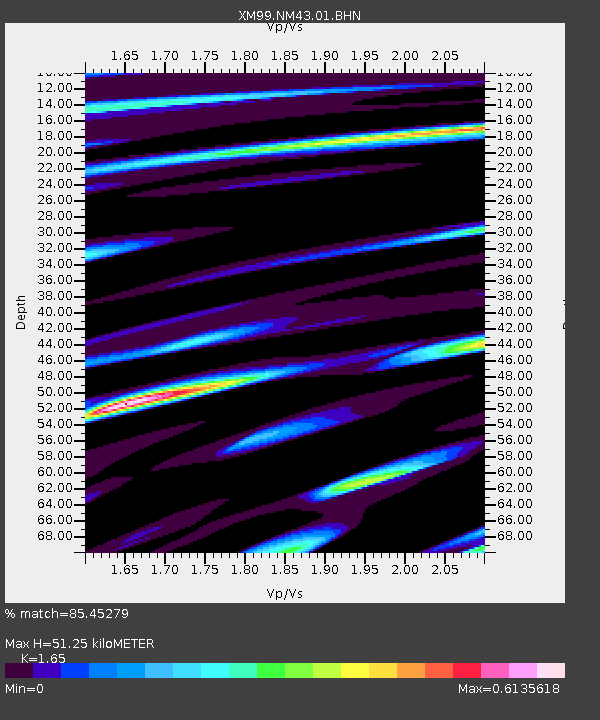
| Estimated Moho Depth: |
51.25 km |
| Estimated Crust Vp/Vs: |
1.65 |
| Assumed Crust Vp: |
6.476 km/s |
| Estimated Crust Vs: |
3.925 km/s |
| Estimated Crust Poisson's Ratio: |
0.21 |
|
| Radial Match: |
85.45279 % |
| Radial Bump: |
400 |
| Transverse Match: |
70.146095 % |
| Transverse Bump: |
400 |
| SOD ConfigId: |
27569 |
| Insert Time: |
2010-02-26 17:36:54.524 +0000 |
| GWidth: |
2.5 |
| Max Bumps: |
400 |
| Tol: |
0.001 |
|
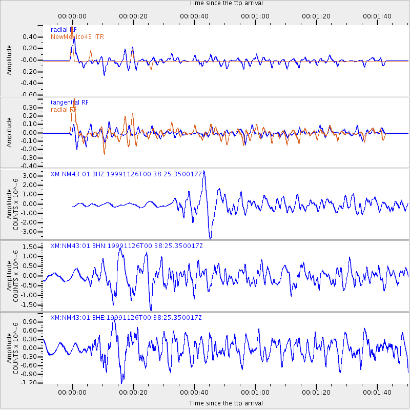
Signal To Noise
| Channel | StoN | STA | LTA |
| XM:NM43:01:BHN:19991126T00:38:25.350017Z | 2.1342576 | 2.225045E-7 | 1.0425381E-7 |
| XM:NM43:01:BHE:19991126T00:38:25.350017Z | 0.82367015 | 1.1071401E-7 | 1.3441547E-7 |
| XM:NM43:01:BHZ:19991126T00:38:25.350017Z | 2.1518853 | 3.173145E-7 | 1.4745883E-7 |
| Arrivals |
| Ps | 5.4 SECOND |
| PpPs | 20 SECOND |
| PsPs/PpSs | 25 SECOND |


