You are here: Home > Network List > XM99 - Rio Grande Seismic Transect Stations List
> Station NM43 NewMexico43 > Earthquake Result Viewer
NM43 NewMexico43 - Earthquake Result Viewer
| Earthquake location: |
Tonga Islands |
| Earthquake latitude/longitude: |
-15.9/-174.0 |
| Earthquake time(UTC): |
1999/12/07 (341) 21:29:49 GMT |
| Earthquake Depth: |
138 km |
| Earthquake Magnitude: |
6.2 MB, 6.4 MW, 6.4 MW |
| Earthquake Catalog/Contributor: |
WHDF/NEIC |
|
| Network: |
XM Rio Grande Seismic Transect |
| Station: |
NM43 NewMexico43 |
| Lat/Lon: |
36.25 N/108.89 W |
| Elevation: |
1991 m |
|
| Distance: |
80.4 deg |
| Az: |
48.042 deg |
| Baz: |
242.271 deg |
| Ray Param: |
0.047997467 |
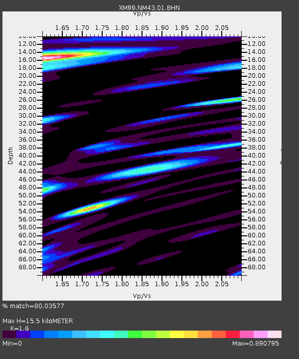
| Estimated Moho Depth: |
15.5 km |
| Estimated Crust Vp/Vs: |
1.60 |
| Assumed Crust Vp: |
6.476 km/s |
| Estimated Crust Vs: |
4.047 km/s |
| Estimated Crust Poisson's Ratio: |
0.18 |
|
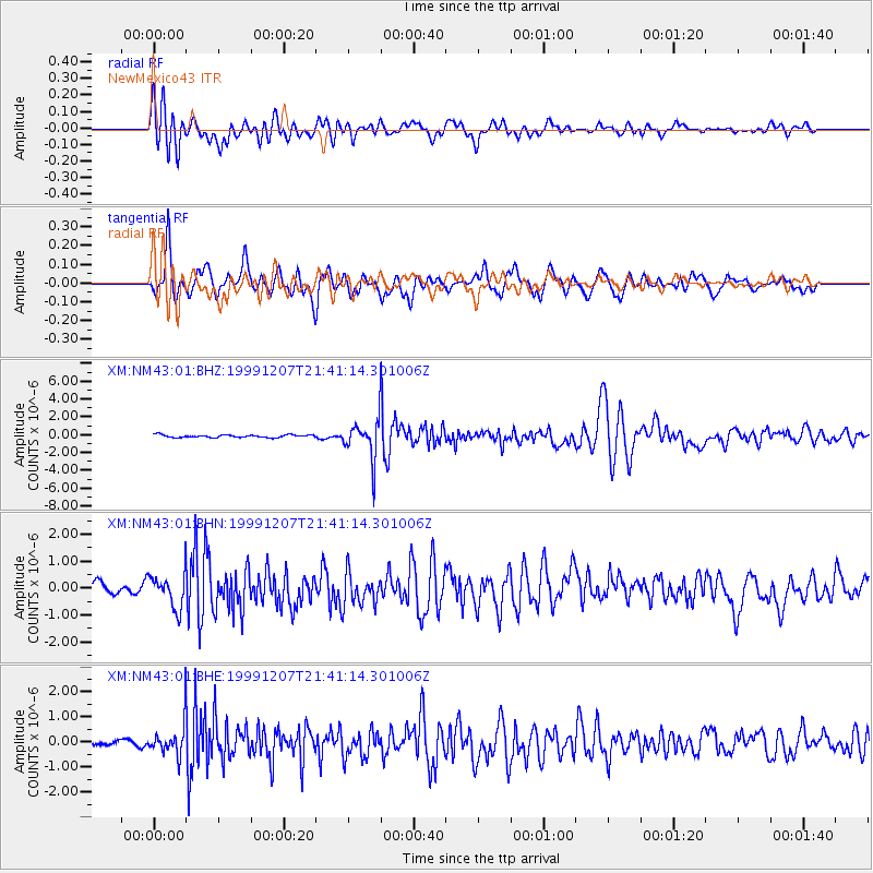
| Radial Match: |
80.03577 % |
| Radial Bump: |
400 |
| Transverse Match: |
84.35138 % |
| Transverse Bump: |
400 |
| SOD ConfigId: |
27569 |
| Insert Time: |
2010-02-26 17:36:56.888 +0000 |
| GWidth: |
2.5 |
| Max Bumps: |
400 |
| Tol: |
0.001 |
|
Signal To Noise
| Channel | StoN | STA | LTA |
| XM:NM43:01:BHN:19991207T21:41:14.301006Z | 2.8687015 | 6.315982E-7 | 2.2016869E-7 |
| XM:NM43:01:BHE:19991207T21:41:14.301006Z | 3.1593795 | 6.073565E-7 | 1.9223917E-7 |
| XM:NM43:01:BHZ:19991207T21:41:14.301006Z | 14.588936 | 2.143251E-6 | 1.4690934E-7 |
| Arrivals |
| Ps | 1.5 SECOND |
| PpPs | 6.0 SECOND |
| PsPs/PpSs | 7.5 SECOND |


