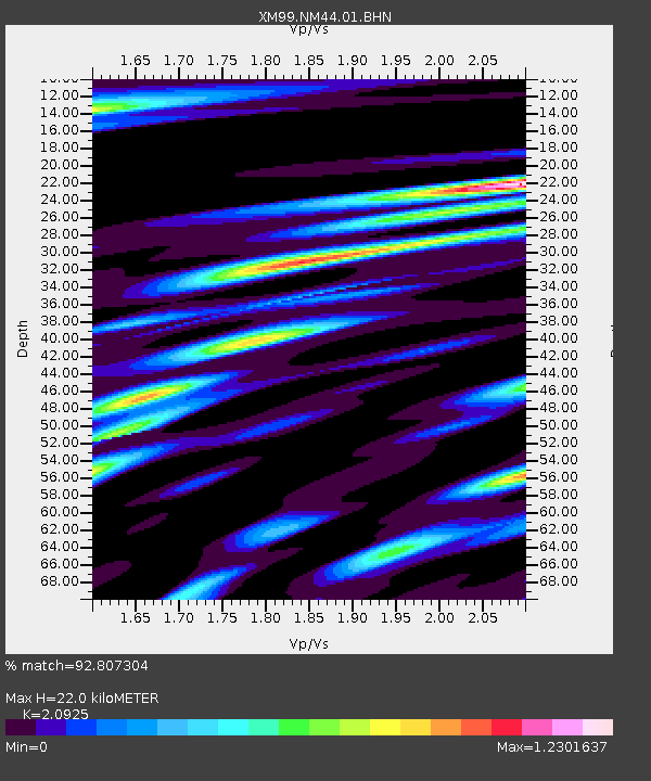
NM44 NewMexico44 - Earthquake Result Viewer
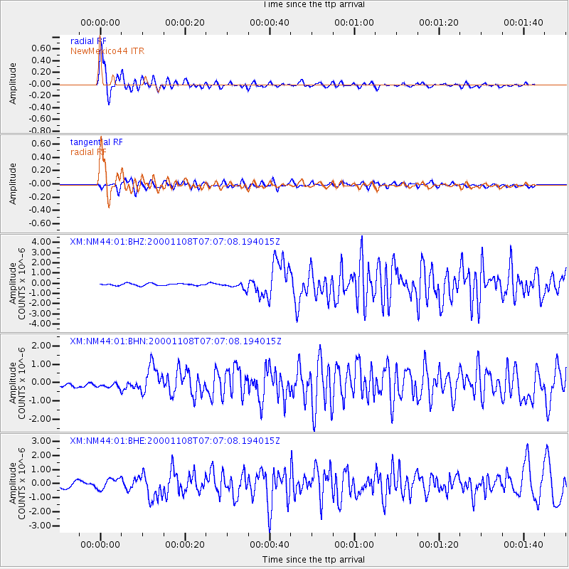
Earthquake location: Panama-Colombia Border Region
Earthquake latitude/longitude: 7.0/-77.8
Earthquake time(UTC): 2000/11/08 (313) 06:59:58 GMT
Earthquake Depth: 17 km
Earthquake Magnitude: 6.0 MB, 6.4 MS, 6.5 MW, 6.2 ML
Earthquake Catalog/Contributor: WHDF/NEIC
Network: XM Rio Grande Seismic Transect
Station: NM44 NewMexico44
Lat/Lon: 36.42 N/108.96 W
Elevation: 1921 m
Distance: 40.8 deg
Az: 320.323 deg
Baz: 128.216 deg
Ray Param: 0.074184015
Estimated Moho Depth: 22.0 km
Estimated Crust Vp/Vs: 2.09
Assumed Crust Vp: 6.476 km/s
Estimated Crust Vs: 3.095 km/s
Estimated Crust Poisson's Ratio: 0.35
Radial Match: 92.807304 %
Radial Bump: 369
Transverse Match: 78.57156 %
Transverse Bump: 400
SOD ConfigId: 16820
Insert Time: 2010-02-26 17:37:08.894 +0000
GWidth: 2.5
Max Bumps: 400
Tol: 0.001

Signal To Noise

ChannelStoNSTALTA
XM:NM44:01:BHN:20001108T07:07:08.194015Z0.93960121.315343E-71.3998951E-7
XM:NM44:01:BHE:20001108T07:07:08.194015Z1.87748063.8323068E-72.0411966E-7
XM:NM44:01:BHZ:20001108T07:07:08.194015Z3.3928553.376823E-79.9527476E-8
Arrivals
Ps3.9 SECOND
PpPs9.9 SECOND
PsPs/PpSs14 SECOND