
Station XM NM44 - NewMexico44
Network: XM99 - Rio Grande Seismic Transect
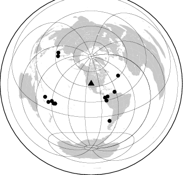
Nearby stations (2 deg radius)
| Station | Name | (Lat, Lon) | Start / End | Elevation |
| NM44 | NewMexico44 | (36.42, -108.96) | 1999-07-28 / 2001-12-31 | 1921 m |
| Crust2 Type: | Q6,orogen/41.5km no ice, cordilleras, 1.5 km seds. |
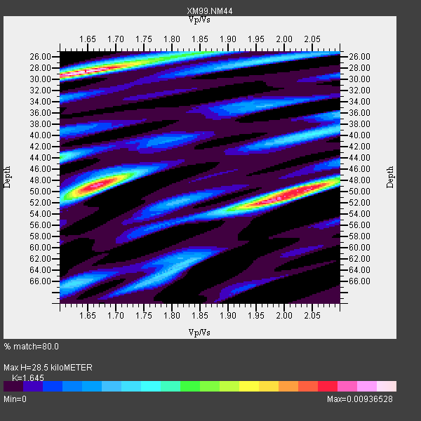
| Thickness Estimate: | 28 km |
| Thickness StdDev: | 9.9 km |
| Vp/Vs Estimate: | 1.64 |
| Vp/Vs StdDev: | 0.18 |
| Vs Estimate: | 3.937 km/s |
| Poisson's Ratio: | 0.21 |
| Peak Value: | 0.01 |
| Assumed Vp: | 6.476 km/s |
| Ps Weight: | 0.33333334 |
| PpPs Weight: | 0.33333334 |
| PsPs Weight: | 0.33333328 |
| Residual Complexity: | 0.860 |
| Nearby stations H: | +- |
| (2.0 deg) Vp/Vs: | +- |
3 with match > 90% ( 20.0 %) and 14 with match > 80% ( 93.333336 %) out of 15.
Download stack as xyz text file.
Azimuth Distribution of Events:
Prior Results for this Station
| Study | Thickness | Vp/Vs | Vp | Vs | Poissons Ratio | Extra |
| EARS | 28 km | 1.64 | 6.476 km/s | 3.937 km/s | 0.21 | |
| Crust2.0 | 42 km | 1.76 | 6.476 km/s | 3.675 km/s | 0.26 | Q6,orogen/41.5km no ice, cordilleras, 1.5 km seds. |
| Wilson | 46 km | 1.75 | 6.28 km/s | 3.589 km/s | 0.26 | |
| Global Maxima | 28 km | 1.64 | 6.476 km/s | 3.937 km/s | 0.21 | amp=0.00936528 |
| Local Maxima 1 | 51 km | 1.99 | 6.476 km/s | 3.254 km/s | 0.33 | amp=0.008489797 |
| Local Maxima 2 | 49 km | 1.66 | 6.476 km/s | 3.889 km/s | 0.22 | amp=0.008194194 |
| Local Maxima 3 | 48 km | 2.07 | 6.476 km/s | 3.132 km/s | 0.35 | amp=0.00515622 |
| Local Maxima 4 | 44 km | 1.60 | 6.476 km/s | 4.047 km/s | 0.18 | amp=0.0044727535 |
| Predicted Arrivals for vertical incidence (zero ray parameter) | |
| Ps | 2.84 SECOND |
| PpPs | 11.64 SECOND |
| PsPs/PpSs | 14.48 SECOND |
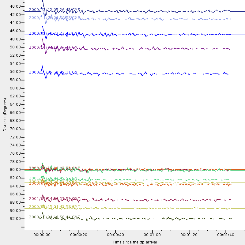
Events Processed for this Station
Download zip of receiver functions as SAC
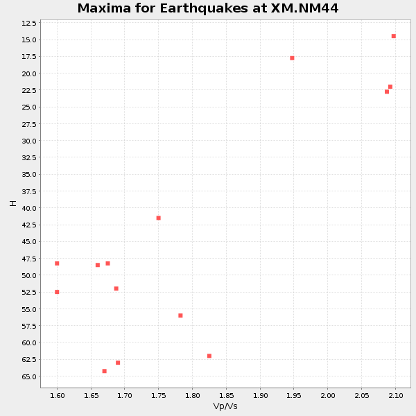
Plot maxima for each earthquake.
Events Used in the Stack
(14 events)| Radial Match | Distance | Baz | FERegion | Time | Lat/Lon | Depth | Magnitude |
| 97.08359 | 48.8 deg | 109.055 deg | Windward Islands | 2000/10/04 14:37:44 GMT | (11.1, -62.6) | 110 km | 5.6 MB, 5.4 MS, 6.1 MW, 5.9 MD |
| 94.667595 | 81.2 deg | 241.216 deg | Tonga Islands | 2000/09/26 06:17:52 GMT | (-17.2, -173.9) | 56 km | 6.1 MB, 6.1 MS, 6.4 MW, 6.1 ME |
| 92.807304 | 40.8 deg | 128.216 deg | Panama-Colombia Border Region | 2000/11/08 06:59:58 GMT | (7.0, -77.8) | 17 km | 6.0 MB, 6.4 MS, 6.5 MW, 6.2 ML |
| 89.84003 | 89.4 deg | 313.171 deg | Western Honshu, Japan | 2001/03/24 06:27:53 GMT | (34.1, 132.5) | 50 km | 6.4 MB, 6.5 MS, 6.8 MW, 6.4 ME |
| 89.81997 | 94.4 deg | 254.203 deg | Vanuatu Islands | 2000/10/04 16:58:44 GMT | (-15.4, 166.9) | 23 km | 6.1 MB, 6.9 MS, 6.8 MW, 6.5 ME |
| 89.335144 | 45.0 deg | 137.744 deg | Near Coast Of Ecuador | 2000/09/28 23:23:43 GMT | (-0.2, -80.6) | 23 km | 5.8 MB, 6.0 MS, 6.6 MW, 6.4 MW |
| 89.27558 | 91.6 deg | 246.955 deg | Vanuatu Islands Region | 2000/02/25 01:43:58 GMT | (-19.5, 173.8) | 33 km | 6.1 MB, 7.1 MS, 7.1 MW, 7.0 MW |
| 87.62136 | 38.7 deg | 135.185 deg | South Of Panama | 2000/12/12 05:26:45 GMT | (6.0, -82.7) | 10 km | 5.8 MB, 5.7 MS, 6.3 ME, 6.1 MW |
| 86.193794 | 84.8 deg | 246.285 deg | Fiji Islands | 2000/09/14 14:59:57 GMT | (-15.7, 179.8) | 33 km | 5.7 MB, 6.2 MS, 6.3 MW, 6.2 MW |
| 85.67957 | 81.3 deg | 241.195 deg | Tonga Islands | 2000/01/26 13:26:50 GMT | (-17.3, -174.0) | 33 km | 5.9 MB, 6.0 MS, 6.4 MW, 6.3 MW |
| 83.97678 | 81.5 deg | 153.644 deg | Off Coast Of Central Chile | 2000/12/20 11:23:54 GMT | (-39.0, -74.7) | 11 km | 6.1 MB, 6.2 MS, 6.4 MW, 6.0 ME |
| 83.96118 | 83.9 deg | 242.482 deg | Fiji Islands Region | 2001/04/28 04:49:53 GMT | (-18.1, -176.9) | 352 km | 6.2 MB, 6.8 MW, 6.8 MW |
| 83.482376 | 55.5 deg | 73.537 deg | Northern Mid-Atlantic Ridge | 2000/10/05 13:39:11 GMT | (31.7, -41.0) | 10 km | 5.4 MB, 6.1 MS, 6.0 MW, 5.9 MW |
| 82.70011 | 85.3 deg | 309.526 deg | Near S. Coast Of Honshu, Japan | 2000/07/01 07:01:55 GMT | (34.2, 139.1) | 10 km | 6.0 MB, 6.1 MS, 6.2 MW, 6.2 MW |
Losers
(1 events)| Radial Match | Distance | Baz | FERegion | Time | Lat/Lon | Depth | Magnitude | Reason |
| 82.199974 | 92.6 deg | 257.774 deg | Santa Cruz Islands | 2000/06/10 09:17:53 GMT | (-11.4, 166.2) | 33 km | 5.4 MB, 5.6 MS, 5.9 MW, 5.9 MW |
