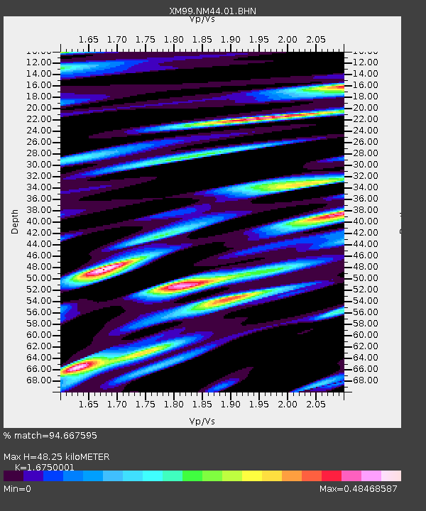
NM44 NewMexico44 - Earthquake Result Viewer
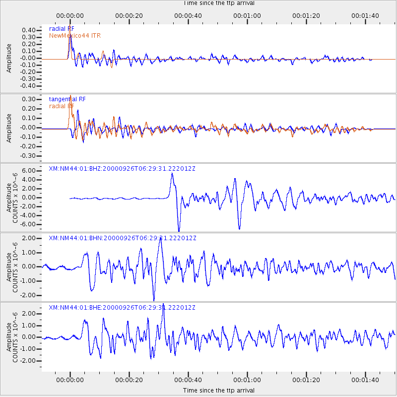
Earthquake location: Tonga Islands
Earthquake latitude/longitude: -17.2/-173.9
Earthquake time(UTC): 2000/09/26 (270) 06:17:52 GMT
Earthquake Depth: 56 km
Earthquake Magnitude: 6.1 MB, 6.1 MS, 6.4 MW, 6.1 ME
Earthquake Catalog/Contributor: WHDF/NEIC
Network: XM Rio Grande Seismic Transect
Station: NM44 NewMexico44
Lat/Lon: 36.42 N/108.96 W
Elevation: 1921 m
Distance: 81.2 deg
Az: 47.688 deg
Baz: 241.216 deg
Ray Param: 0.047637645
Estimated Moho Depth: 48.25 km
Estimated Crust Vp/Vs: 1.68
Assumed Crust Vp: 6.476 km/s
Estimated Crust Vs: 3.866 km/s
Estimated Crust Poisson's Ratio: 0.22
Radial Match: 94.667595 %
Radial Bump: 400
Transverse Match: 93.147156 %
Transverse Bump: 400
SOD ConfigId: 16820
Insert Time: 2010-02-26 17:37:13.268 +0000
GWidth: 2.5
Max Bumps: 400
Tol: 0.001

Signal To Noise

ChannelStoNSTALTA
XM:NM44:01:BHN:20000926T06:29:31.222012Z2.50037262.788587E-71.11526845E-7
XM:NM44:01:BHE:20000926T06:29:31.222012Z5.40819074.6795506E-78.6527095E-8
XM:NM44:01:BHZ:20000926T06:29:31.222012Z18.551821.949392E-61.05078215E-7
Arrivals
Ps5.2 SECOND
PpPs19 SECOND
PsPs/PpSs25 SECOND