You are here: Home > Network List > XM99 - Rio Grande Seismic Transect Stations List
> Station MB04B Magmabody04b > Earthquake Result Viewer
MB04B Magmabody04b - Earthquake Result Viewer
| Earthquake location: |
Fiji Islands Region |
| Earthquake latitude/longitude: |
-18.1/-176.9 |
| Earthquake time(UTC): |
2001/04/28 (118) 04:49:53 GMT |
| Earthquake Depth: |
352 km |
| Earthquake Magnitude: |
6.2 MB, 6.8 MW, 6.8 MW |
| Earthquake Catalog/Contributor: |
WHDF/NEIC |
|
| Network: |
XM Rio Grande Seismic Transect |
| Station: |
MB04B Magmabody04b |
| Lat/Lon: |
34.07 N/106.94 W |
| Elevation: |
1489 m |
|
| Distance: |
84.4 deg |
| Az: |
51.609 deg |
| Baz: |
243.931 deg |
| Ray Param: |
0.044616647 |
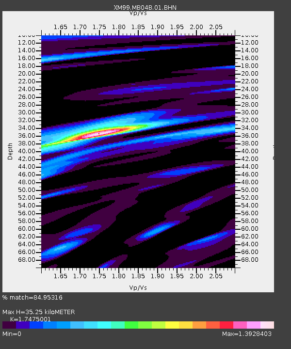
| Estimated Moho Depth: |
35.25 km |
| Estimated Crust Vp/Vs: |
1.75 |
| Assumed Crust Vp: |
6.502 km/s |
| Estimated Crust Vs: |
3.72 km/s |
| Estimated Crust Poisson's Ratio: |
0.26 |
|
| Radial Match: |
84.95316 % |
| Radial Bump: |
400 |
| Transverse Match: |
67.4247 % |
| Transverse Bump: |
400 |
| SOD ConfigId: |
4714 |
| Insert Time: |
2010-02-26 17:37:28.629 +0000 |
| GWidth: |
2.5 |
| Max Bumps: |
400 |
| Tol: |
0.001 |
|
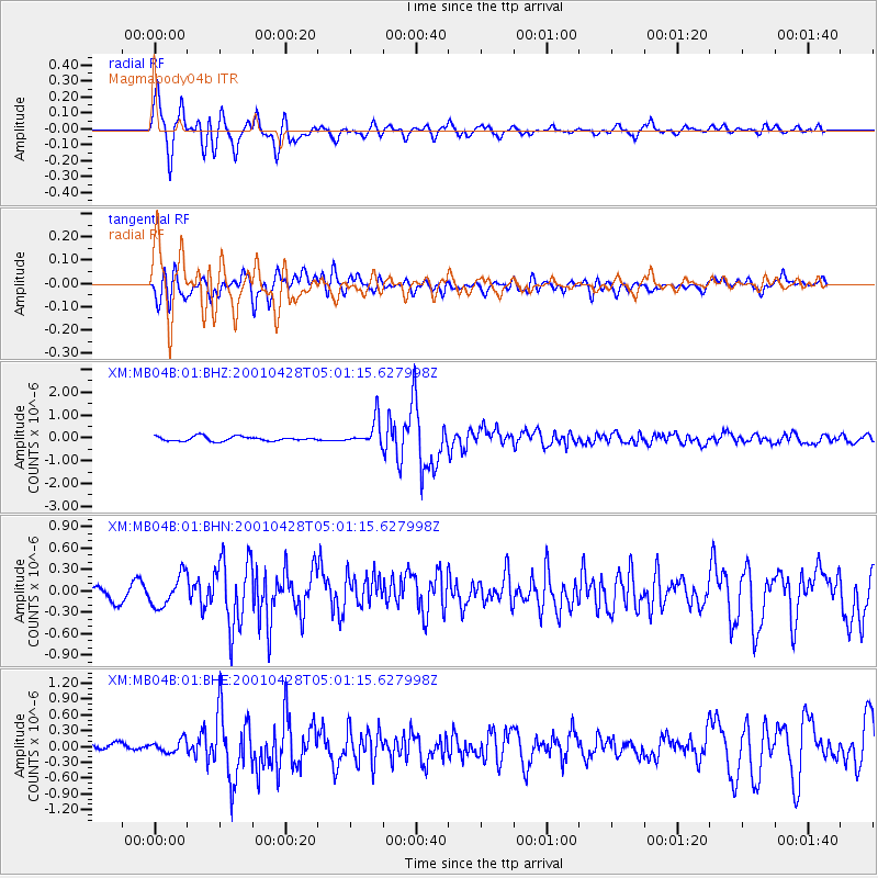
Signal To Noise
| Channel | StoN | STA | LTA |
| XM:MB04B:01:BHN:20010428T05:01:15.627998Z | 2.2056868 | 2.2030235E-7 | 9.987926E-8 |
| XM:MB04B:01:BHE:20010428T05:01:15.627998Z | 1.7252779 | 1.1635148E-7 | 6.743927E-8 |
| XM:MB04B:01:BHZ:20010428T05:01:15.627998Z | 5.825979 | 5.6940524E-7 | 9.773555E-8 |
| Arrivals |
| Ps | 4.2 SECOND |
| PpPs | 15 SECOND |
| PsPs/PpSs | 19 SECOND |


