
Station XM MB04B - Magmabody04b
Network: XM99 - Rio Grande Seismic Transect
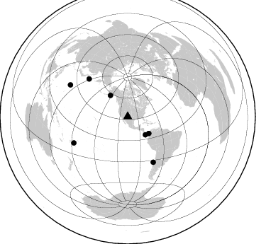
Nearby stations (2 deg radius)
| Station | Name | (Lat, Lon) | Start / End | Elevation |
| MB04B | Magmabody04b | (34.07, -106.94) | 2000-03-08 / 2001-12-31 | 1489 m |
| Crust2 Type: | X2,Rift, Rio Grande, Baikal, 0.5km sediments |
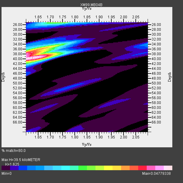
| Thickness Estimate: | 40 km |
| Thickness StdDev: | 3.9 km |
| Vp/Vs Estimate: | 1.62 |
| Vp/Vs StdDev: | 0.05 |
| Vs Estimate: | 4.001 km/s |
| Poisson's Ratio: | 0.20 |
| Peak Value: | 0.05 |
| Assumed Vp: | 6.502 km/s |
| Ps Weight: | 0.33333334 |
| PpPs Weight: | 0.33333334 |
| PsPs Weight: | 0.33333328 |
| Residual Complexity: | 0.636 |
| Nearby stations H: | 40 km +- 0.7 km |
| (2.0 deg) Vp/Vs: | 1.74 +- 0.17 |
4 with match > 90% ( 50.0 %) and 7 with match > 80% ( 87.5 %) out of 8.
Download stack as xyz text file.
Azimuth Distribution of Events:
Prior Results for this Station
| Study | Thickness | Vp/Vs | Vp | Vs | Poissons Ratio | Extra |
| EARS | 40 km | 1.62 | 6.502 km/s | 4.001 km/s | 0.20 | |
| Crust2.0 | 33 km | 1.77 | 6.502 km/s | 3.68 km/s | 0.26 | X2,Rift, Rio Grande, Baikal, 0.5km sediments |
| Global Maxima | 40 km | 1.62 | 6.502 km/s | 4.001 km/s | 0.20 | amp=0.04779338 |
| Local Maxima 1 | 38 km | 1.61 | 6.502 km/s | 4.051 km/s | 0.18 | amp=0.03826526 |
| Local Maxima 2 | 25 km | 1.72 | 6.502 km/s | 3.774 km/s | 0.25 | amp=0.02536717 |
| Local Maxima 3 | 35 km | 1.71 | 6.502 km/s | 3.808 km/s | 0.24 | amp=0.018377243 |
| Local Maxima 4 | 39 km | 1.60 | 6.502 km/s | 4.063 km/s | 0.18 | amp=0.015099235 |
| Predicted Arrivals for vertical incidence (zero ray parameter) | |
| Ps | 3.80 SECOND |
| PpPs | 15.95 SECOND |
| PsPs/PpSs | 19.75 SECOND |
Events Processed for this Station
Download zip of receiver functions as SAC
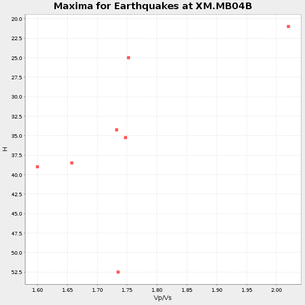
Plot maxima for each earthquake.
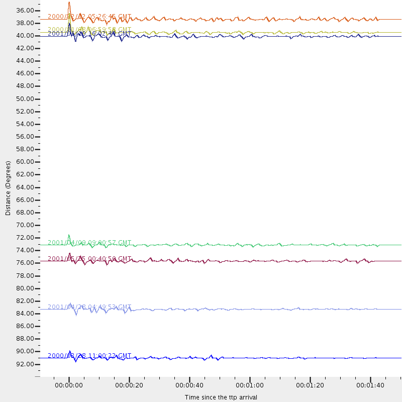
Events Used in the Stack
(7 events)| Radial Match | Distance | Baz | FERegion | Time | Lat/Lon | Depth | Magnitude |
| 94.75267 | 92.5 deg | 299.014 deg | Volcano Islands, Japan Region | 2000/03/28 11:00:22 GMT | (22.3, 143.7) | 126 km | 6.8 MB, 7.6 MS, 7.6 MW, 7.6 MW |
| 92.51706 | 73.6 deg | 150.693 deg | Off Coast Of Central Chile | 2001/04/09 09:00:57 GMT | (-32.7, -73.1) | 11 km | 6.1 MB, 6.3 MS, 6.7 MW, 6.3 ME |
| 92.07567 | 76.3 deg | 314.325 deg | Kuril Islands | 2001/05/25 00:40:50 GMT | (44.3, 148.4) | 33 km | 6.1 MB, 6.7 MS, 6.7 MW, 6.6 MW |
| 91.24567 | 38.0 deg | 128.379 deg | Panama-Colombia Border Region | 2000/11/08 06:59:58 GMT | (7.0, -77.8) | 17 km | 6.0 MB, 6.4 MS, 6.5 MW, 6.2 ML |
| 86.03299 | 35.8 deg | 135.727 deg | South Of Panama | 2000/12/12 05:26:45 GMT | (6.0, -82.7) | 10 km | 5.8 MB, 5.7 MS, 6.3 ME, 6.1 MW |
| 84.95316 | 84.4 deg | 243.931 deg | Fiji Islands Region | 2001/04/28 04:49:53 GMT | (-18.1, -176.9) | 352 km | 6.2 MB, 6.8 MW, 6.8 MW |
| 83.587265 | 38.7 deg | 320.863 deg | Kodiak Island Region, Alaska | 2001/01/10 16:02:44 GMT | (57.1, -153.2) | 33 km | 6.2 MB, 6.8 MS, 7.1 MW, 6.8 ML |
Losers
(1 events)| Radial Match | Distance | Baz | FERegion | Time | Lat/Lon | Depth | Magnitude | Reason |
| 95.52324 | 96.5 deg | 247.968 deg | Southeast Of Loyalty Islands | 2001/02/28 13:05:31 GMT | (-22.0, 170.1) | 10 km | 5.8 MB, 6.1 MS, 6.2 MW |
