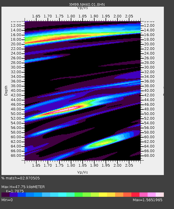
NM40 NewMexico40 - Earthquake Result Viewer

Earthquake location: Kodiak Island Region, Alaska
Earthquake latitude/longitude: 57.1/-153.2
Earthquake time(UTC): 2001/01/10 (010) 16:02:44 GMT
Earthquake Depth: 33 km
Earthquake Magnitude: 6.2 MB, 6.8 MS, 7.1 MW, 6.8 ML
Earthquake Catalog/Contributor: WHDF/NEIC
Network: XM Rio Grande Seismic Transect
Station: NM40 NewMexico40
Lat/Lon: 35.95 N/108.43 W
Elevation: 1796 m
Distance: 36.5 deg
Az: 105.95 deg
Baz: 319.681 deg
Ray Param: 0.07659878
Estimated Moho Depth: 47.75 km
Estimated Crust Vp/Vs: 1.79
Assumed Crust Vp: 6.496 km/s
Estimated Crust Vs: 3.634 km/s
Estimated Crust Poisson's Ratio: 0.27
Radial Match: 82.970505 %
Radial Bump: 332
Transverse Match: 75.37038 %
Transverse Bump: 400
SOD ConfigId: 16820
Insert Time: 2010-02-26 17:37:43.195 +0000
GWidth: 2.5
Max Bumps: 400
Tol: 0.001

Signal To Noise

ChannelStoNSTALTA
XM:NM40:01:BHN:20010110T16:09:15.774006Z1.11906738.0984194E-77.236758E-7
XM:NM40:01:BHE:20010110T16:09:15.774006Z0.8225847.9023243E-79.606708E-7
XM:NM40:01:BHZ:20010110T16:09:15.774006Z4.33682541.2811495E-62.9541184E-7
Arrivals
Ps6.2 SECOND
PpPs19 SECOND
PsPs/PpSs25 SECOND