
Station XM NM40 - NewMexico40
Network: XM99 - Rio Grande Seismic Transect
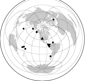
Nearby stations (2 deg radius)
| Station | Name | (Lat, Lon) | Start / End | Elevation |
| NM40 | NewMexico40 | (35.95, -108.43) | 1999-07-07 / 2001-12-31 | 1796 m |
| Crust2 Type: | H7,early/mid Proter. shield, Austr., 1.5 km seds. |
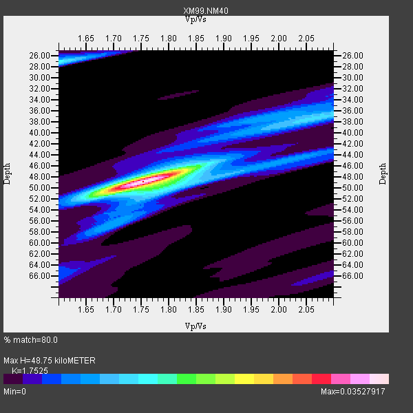
| Thickness Estimate: | 49 km |
| Thickness StdDev: | 1.7 km |
| Vp/Vs Estimate: | 1.75 |
| Vp/Vs StdDev: | 0.04 |
| Vs Estimate: | 3.707 km/s |
| Poisson's Ratio: | 0.26 |
| Peak Value: | 0.04 |
| Assumed Vp: | 6.496 km/s |
| Ps Weight: | 0.33333334 |
| PpPs Weight: | 0.33333334 |
| PsPs Weight: | 0.33333328 |
| Residual Complexity: | 0.455 |
| Nearby stations H: | +- |
| (2.0 deg) Vp/Vs: | +- |
5 with match > 90% ( 33.333332 %) and 14 with match > 80% ( 93.333336 %) out of 15.
Download stack as xyz text file.
Azimuth Distribution of Events:
Prior Results for this Station
| Study | Thickness | Vp/Vs | Vp | Vs | Poissons Ratio | Extra |
| EARS | 49 km | 1.75 | 6.496 km/s | 3.707 km/s | 0.26 | |
| Crust2.0 | 38 km | 1.78 | 6.496 km/s | 3.647 km/s | 0.27 | H7,early/mid Proter. shield, Austr., 1.5 km seds. |
| Wilson | 47 km | 1.76 | 6.23 km/s | 3.54 km/s | 0.26 | |
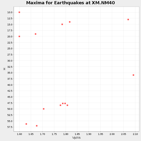
| Global Maxima | 49 km | 1.75 | 6.496 km/s | 3.707 km/s | 0.26 | amp=0.03527917 |
| Local Maxima 1 | 27 km | 1.60 | 6.496 km/s | 4.06 km/s | 0.18 | amp=0.013248256 |
| Local Maxima 2 | 50 km | 1.80 | 6.496 km/s | 3.619 km/s | 0.27 | amp=0.01223842 |
| Local Maxima 3 | 37 km | 2.08 | 6.496 km/s | 3.127 km/s | 0.35 | amp=0.010610075 |
| Local Maxima 4 | 46 km | 1.81 | 6.496 km/s | 3.589 km/s | 0.28 | amp=0.00802091 |
| Predicted Arrivals for vertical incidence (zero ray parameter) | |
| Ps | 5.65 SECOND |
| PpPs | 20.66 SECOND |
| PsPs/PpSs | 26.30 SECOND |
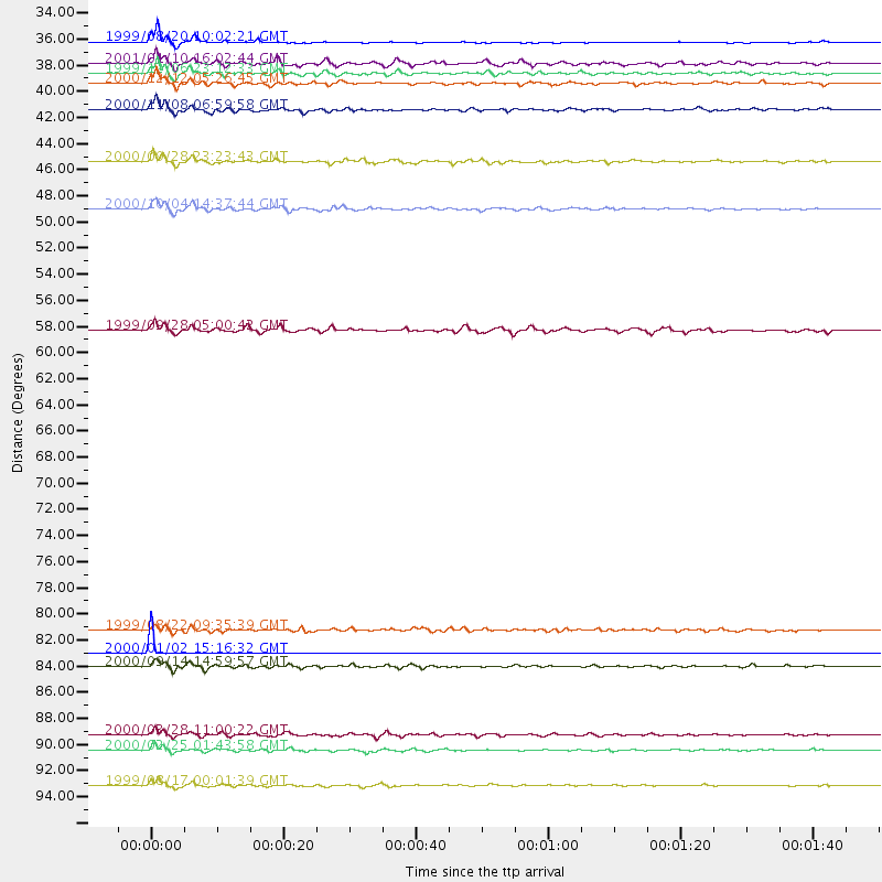
Events Processed for this Station
Download zip of receiver functions as SAC
Plot maxima for each earthquake.
Events Used in the Stack
(14 events)| Radial Match | Distance | Baz | FERegion | Time | Lat/Lon | Depth | Magnitude |
| 99.79285 | 84.0 deg | 239.133 deg | Tonga Islands | 2000/01/02 15:16:32 GMT | (-20.8, -174.2) | 33 km | 5.5 MB, 5.8 MS, 5.8 MW, 5.8 MW |
| 96.485245 | 48.2 deg | 109.093 deg | Windward Islands | 2000/10/04 14:37:44 GMT | (11.1, -62.6) | 110 km | 5.6 MB, 5.4 MS, 6.1 MW, 5.9 MD |
| 94.940865 | 37.2 deg | 319.911 deg | Kodiak Island Region, Alaska | 1999/12/06 23:12:33 GMT | (57.4, -154.5) | 66 km | 6.8 MB, 7.0 MW, 7.0 ML |
| 94.33606 | 34.7 deg | 134.539 deg | Costa Rica | 1999/08/20 10:02:21 GMT | (9.0, -84.2) | 20 km | 6.1 MB, 6.9 MS, 7.0 MW, 6.1 ML |
| 91.726555 | 90.5 deg | 298.193 deg | Volcano Islands, Japan Region | 2000/03/28 11:00:22 GMT | (22.3, 143.7) | 126 km | 6.8 MB, 7.6 MS, 7.6 MW, 7.6 MW |
| 89.58263 | 94.6 deg | 30.472 deg | Turkey | 1999/08/17 00:01:39 GMT | (40.7, 29.9) | 17 km | 6.3 MB, 7.8 MS, 7.7 ME, 7.6 MW |
| 89.0875 | 40.1 deg | 128.401 deg | Panama-Colombia Border Region | 2000/11/08 06:59:58 GMT | (7.0, -77.8) | 17 km | 6.0 MB, 6.4 MS, 6.5 MW, 6.2 ML |
| 88.82893 | 85.0 deg | 246.651 deg | Fiji Islands | 2000/09/14 14:59:57 GMT | (-15.7, 179.8) | 33 km | 5.7 MB, 6.2 MS, 6.3 MW, 6.2 MW |
| 88.015205 | 82.1 deg | 154.738 deg | Off Coast Of Southern Chile | 1999/08/22 09:35:39 GMT | (-40.5, -74.8) | 33 km | 6.2 MB, 5.8 MS, 6.4 MW, 6.2 MW |
| 87.819595 | 58.0 deg | 317.016 deg | Komandorskiye Ostrova Region | 1999/09/28 05:00:42 GMT | (54.6, 168.3) | 33 km | 5.4 MB, 6.1 MS, 6.1 MW, 6.1 MW |
| 87.35409 | 91.8 deg | 247.248 deg | Vanuatu Islands Region | 2000/02/25 01:43:58 GMT | (-19.5, 173.8) | 33 km | 6.1 MB, 7.1 MS, 7.1 MW, 7.0 MW |
| 86.721214 | 44.3 deg | 138.054 deg | Near Coast Of Ecuador | 2000/09/28 23:23:43 GMT | (-0.2, -80.6) | 23 km | 5.8 MB, 6.0 MS, 6.6 MW, 6.4 MW |
| 82.970505 | 36.5 deg | 319.681 deg | Kodiak Island Region, Alaska | 2001/01/10 16:02:44 GMT | (57.1, -153.2) | 33 km | 6.2 MB, 6.8 MS, 7.1 MW, 6.8 ML |
| 81.61509 | 38.0 deg | 135.459 deg | South Of Panama | 2000/12/12 05:26:45 GMT | (6.0, -82.7) | 10 km | 5.8 MB, 5.7 MS, 6.3 ME, 6.1 MW |
Losers
(1 events)| Radial Match | Distance | Baz | FERegion | Time | Lat/Lon | Depth | Magnitude | Reason |
| 92.764854 | 96.1 deg | 247.361 deg | Southeast Of Loyalty Islands | 2001/02/28 13:05:31 GMT | (-22.0, 170.1) | 10 km | 5.8 MB, 6.1 MS, 6.2 MW |
