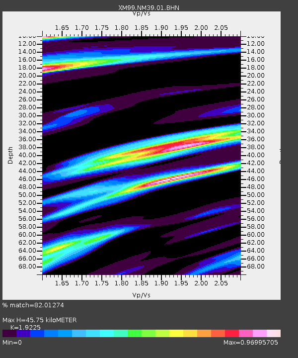
NM39 NewMexico39 - Earthquake Result Viewer

Earthquake location: Kodiak Island Region, Alaska
Earthquake latitude/longitude: 57.1/-153.2
Earthquake time(UTC): 2001/01/10 (010) 16:02:44 GMT
Earthquake Depth: 33 km
Earthquake Magnitude: 6.2 MB, 6.8 MS, 7.1 MW, 6.8 ML
Earthquake Catalog/Contributor: WHDF/NEIC
Network: XM Rio Grande Seismic Transect
Station: NM39 NewMexico39
Lat/Lon: 35.79 N/108.27 W
Elevation: 1949 m
Distance: 36.7 deg
Az: 105.947 deg
Baz: 319.772 deg
Ray Param: 0.07648941
Estimated Moho Depth: 45.75 km
Estimated Crust Vp/Vs: 1.92
Assumed Crust Vp: 6.496 km/s
Estimated Crust Vs: 3.379 km/s
Estimated Crust Poisson's Ratio: 0.31
Radial Match: 82.01274 %
Radial Bump: 330
Transverse Match: 73.4516 %
Transverse Bump: 400
SOD ConfigId: 16820
Insert Time: 2010-02-26 17:38:06.416 +0000
GWidth: 2.5
Max Bumps: 400
Tol: 0.001

Signal To Noise

ChannelStoNSTALTA
XM:NM39:01:BHN:20010110T16:09:17.477009Z1.06944698.7652904E-78.196097E-7
XM:NM39:01:BHE:20010110T16:09:17.477009Z0.658574643.329863E-75.0561664E-7
XM:NM39:01:BHZ:20010110T16:09:17.477009Z2.92541221.3960343E-64.772094E-7
Arrivals
Ps7.0 SECOND
PpPs19 SECOND
PsPs/PpSs26 SECOND